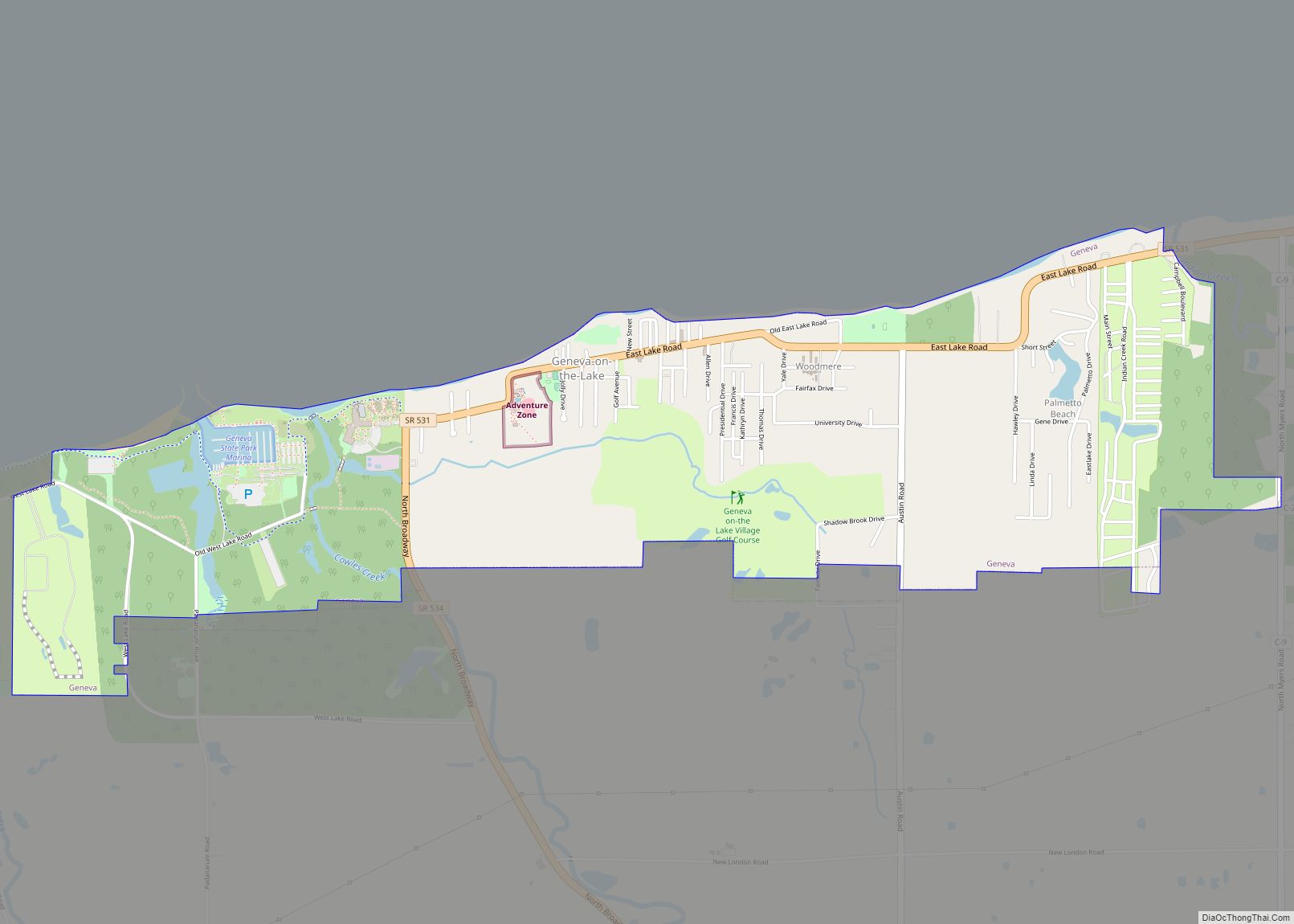
Map of Gates Mills village

Map of Gates Mills village

Gates Mills is a village in eastern Cuyahoga County, Ohio, United States. A suburb of Cleveland, it is part of the Cleveland metropolitan area. The population was 2,264 at the 2020 census. Gates Mills village overview: Name: Gates Mills village LSAD Code: 47 LSAD Description: village (suffix) State: Ohio County: Cuyahoga County Founded: 1826 Incorporated: … Read more

Map of Glendale village, Ohio

Map of Glendale village, Ohio

Glendale is a village in Hamilton County, Ohio, United States. The population was 2,298 at the 2020 census. It is a northern suburb of Cincinnati, and is the site of the Glendale Historic District. Glendale village overview: Name: Glendale village LSAD Code: 47 LSAD Description: village (suffix) State: Ohio County: Hamilton County Elevation: 630 ft (192 m) … Read more

Map of Glencoe CDP, Ohio

Map of Glencoe CDP, Ohio

Glencoe is a census-designated place in southern Richland Township, Belmont County, Ohio, United States. As of the 2010 census it had a population of 310. It has a post office with the ZIP code 43928. Glencoe is part of the Wheeling, WV-OH Metropolitan Statistical Area. Glencoe CDP overview: Name: Glencoe CDP LSAD Code: 57 LSAD … Read more

Map of Glandorf village

Map of Glandorf village

Glandorf is a village in Putnam County, Ohio, United States. The population was 1,001 at the 2010 census. Glandorf village overview: Name: Glandorf village LSAD Code: 47 LSAD Description: village (suffix) State: Ohio County: Putnam County Elevation: 728 ft (222 m) Total Area: 1.64 sq mi (4.24 km²) Land Area: 1.64 sq mi (4.24 km²) Water Area: 0.00 sq mi (0.00 km²) Total Population: 969 Population … Read more

Map of Girard city, Ohio

Map of Girard city, Ohio

Girard is a city in southern Trumbull County, Ohio, United States, along the Mahoning River. The population was 9,603 at the 2020 census. Located directly north of Youngstown, it is a suburb of the Youngstown–Warren metropolitan area. Girard city overview: Name: Girard city LSAD Code: 25 LSAD Description: city (suffix) State: Ohio County: Trumbull County … Read more

Map of Gilboa village

Map of Gilboa village

Gilboa is a village in Putnam County, Ohio, United States. The village is named after Mount Gilboa. The population was 184 at the 2010 census. Gilboa village overview: Name: Gilboa village LSAD Code: 47 LSAD Description: village (suffix) State: Ohio County: Putnam County Elevation: 748 ft (228 m) Total Area: 0.13 sq mi (0.34 km²) Land Area: 0.13 sq mi (0.34 km²) Water … Read more

Map of Gibsonburg village

Map of Gibsonburg village

Gibsonburg is a village in Sandusky County, Ohio, United States, about 33 miles (53 km) southeast of Toledo. The population was 2,452 at the 2020 census. The National Arbor Day Foundation has designated Gibsonburg as a Tree City USA. Gibsonburg village overview: Name: Gibsonburg village LSAD Code: 47 LSAD Description: village (suffix) State: Ohio County: Sandusky … Read more

Map of Gettysburg village

Map of Gettysburg village, Ohio

Gettysburg is a village in Darke County, Ohio, United States. The population was 513 at the 2010 census. Gettysburg village overview: Name: Gettysburg village LSAD Code: 47 LSAD Description: village (suffix) State: Ohio County: Darke County Elevation: 991 ft (302 m) Total Area: 0.44 sq mi (1.14 km²) Land Area: 0.44 sq mi (1.13 km²) Water Area: 0.00 sq mi (0.00 km²) Total Population: 463 Population … Read more

Map of Germantown city, Ohio

Map of Germantown city, Ohio

Germantown is a city in Montgomery County, Ohio, United States. The population was 5,796 at the 2020 census. A part of the Dayton metropolitan area, Germantown was founded by German Americans from Pennsylvania and was once home to a cigar industry. Germantown city overview: Name: Germantown city LSAD Code: 25 LSAD Description: city (suffix) State: … Read more

Map of Georgetown village, Ohio

Map of Georgetown village, Ohio

Georgetown is a village in Brown County, Ohio, United States located about 36 miles southeast of Cincinnati. The population was 4,331 at the 2010 census. It is the county seat of Brown County. Georgetown was the childhood home of Ulysses S. Grant. Georgetown village overview: Name: Georgetown village LSAD Code: 47 LSAD Description: village (suffix) … Read more

Map of Genoa village, Ohio

Map of Genoa village, Ohio

Genoa is a village in Ottawa County, Ohio, United States. The population was 2,336 at the 2010 census. Originally settled as Stony Ridge, it took its present name in 1856 and was incorporated as a village on December 10, 1868. Genoa village overview: Name: Genoa village LSAD Code: 47 LSAD Description: village (suffix) State: Ohio … Read more

Map of Glenmoor CDP

Map of Glenmoor CDP

Glenmoor is an unincorporated community and census-designated place in southwestern St. Clair Township, Columbiana County, Ohio, United States. The population was 1,829 at the 2020 census. Glenmoor is located in the Salem micropolitan area and the greater Youngstown–Warren area. Glenmoor CDP overview: Name: Glenmoor CDP LSAD Code: 57 LSAD Description: CDP (suffix) State: Ohio County: … Read more