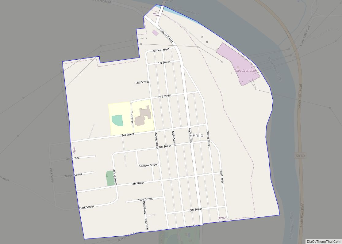
Map of Pigeon Creek CDP

Map of Pigeon Creek CDP

Pigeon Creek is a census-designated place (CDP) in Summit County, Ohio, United States. The population was 945 at the 2000 census. It is part of the Akron metropolitan statistical area. Pigeon Creek CDP overview: Name: Pigeon Creek CDP LSAD Code: 57 LSAD Description: CDP (suffix) State: Ohio County: Summit County Elevation: 1,040 ft (317 m) Total Area: … Read more

Map of Pleasantville village, Ohio

Map of Pleasantville village, Ohio

Pleasantville is a village in Fairfield County, Ohio, United States. The population was 960 at the 2010 census. Pleasantville village overview: Name: Pleasantville village LSAD Code: 47 LSAD Description: village (suffix) State: Ohio County: Fairfield County Elevation: 909 ft (277 m) Total Area: 0.27 sq mi (0.70 km²) Land Area: 0.27 sq mi (0.70 km²) Water Area: 0.00 sq mi (0.00 km²) Total Population: 934 Population … Read more

Map of Pleasant Run CDP

Map of Pleasant Run CDP

Pleasant Run is a census-designated place (CDP) in Hamilton County, Ohio, United States. The population was 4,861 at the 2020 census. Pleasant Run CDP overview: Name: Pleasant Run CDP LSAD Code: 57 LSAD Description: CDP (suffix) State: Ohio County: Hamilton County Elevation: 748 ft (228 m) Total Area: 2.07 sq mi (5.36 km²) Land Area: 2.07 sq mi (5.36 km²) Water Area: 0.00 sq mi … Read more

Map of Pleasant Run Farm CDP

Map of Pleasant Run Farm CDP

Pleasant Run Farms is a census-designated place (CDP) in Hamilton County, Ohio, United States. The population was 4,779 at the 2020 census. Pleasant Run Farm CDP overview: Name: Pleasant Run Farm CDP LSAD Code: 57 LSAD Description: CDP (suffix) State: Ohio County: Hamilton County Elevation: 764 ft (233 m) Total Area: 1.06 sq mi (2.75 km²) Land Area: 1.06 sq mi (2.75 km²) … Read more

Map of Pleasant Plain village, Ohio

Map of Pleasant Plain village, Ohio

Pleasant Plain is a village in Harlan Township, Warren County, Ohio, United States. The population was 129 at the 2020 census. Pleasant Plain village overview: Name: Pleasant Plain village LSAD Code: 47 LSAD Description: village (suffix) State: Ohio County: Warren County Elevation: 886 ft (270 m) Total Area: 0.16 sq mi (0.42 km²) Land Area: 0.16 sq mi (0.42 km²) Water Area: 0.00 sq mi … Read more

Map of Pleasant Hills CDP, Ohio

Map of Pleasant Hills CDP, Ohio

Pleasant Hills is a census-designated place (CDP) in Hamilton County, Ohio, United States. The population was 950 at the 2020 census. Pleasant Hills CDP overview: Name: Pleasant Hills CDP LSAD Code: 57 LSAD Description: CDP (suffix) State: Ohio County: Hamilton County Elevation: 790 ft (240 m) Total Area: 0.36 sq mi (0.92 km²) Land Area: 0.36 sq mi (0.92 km²) Water Area: 0.00 sq mi … Read more

Map of Pleasant Hill village, Ohio

Map of Pleasant Hill village, Ohio

Pleasant Hill is a village in Miami County, Ohio, United States. The population was 1,200 at the 2010 census. It is part of the Dayton Metropolitan Statistical Area. Pleasant Hill village overview: Name: Pleasant Hill village LSAD Code: 47 LSAD Description: village (suffix) State: Ohio County: Miami County Elevation: 932 ft (284 m) Total Area: 0.63 sq mi (1.63 km²) … Read more

Map of Pleasant Grove CDP, Ohio

Map of Pleasant Grove CDP, Ohio

Pleasant Grove is a census-designated place (CDP) in Muskingum County, Ohio, United States. The population was 2,016 at the 2000 census. Pleasant Grove CDP overview: Name: Pleasant Grove CDP LSAD Code: 57 LSAD Description: CDP (suffix) State: Ohio County: Muskingum County Elevation: 932 ft (284 m) Total Area: 3.22 sq mi (8.35 km²) Land Area: 3.21 sq mi (8.33 km²) Water Area: 0.01 sq mi … Read more

Map of Pleasant City village

Map of Pleasant City village

Pleasant City is a village in Guernsey County, Ohio, United States. The population was 447 at the 2010 census. Pleasant City village overview: Name: Pleasant City village LSAD Code: 47 LSAD Description: village (suffix) State: Ohio County: Guernsey County Elevation: 823 ft (251 m) Total Area: 0.18 sq mi (0.46 km²) Land Area: 0.18 sq mi (0.46 km²) Water Area: 0.00 sq mi (0.00 km²) Total … Read more

Map of Plainville CDP, Ohio

Map of Plainville CDP, Ohio

Plainville is a census-designated place (CDP) in Hamilton County, Ohio, United States. The population was 120 at the 2020 census. Plainville CDP overview: Name: Plainville CDP LSAD Code: 57 LSAD Description: CDP (suffix) State: Ohio County: Hamilton County Elevation: 499 ft (152 m) Total Area: 0.09 sq mi (0.24 km²) Land Area: 0.09 sq mi (0.24 km²) Water Area: 0.00 sq mi (0.00 km²) Total Population: … Read more

Map of Plumwood CDP

Map of Plumwood CDP

Plumwood is a census-designated place in central Monroe Township, Madison County, Ohio, United States. It lies at the intersection of State Route 38 with Arthur Bradley Road, 8½ miles (13½ km) north of the city of London, the county seat of Madison County. The Spring Fork of the Little Darby Creek flows past the community. … Read more

Map of Portage village, Ohio

Map of Portage village, Ohio

Portage is a village in Wood County, Ohio, United States. The population was 438 at the 2010 census. Portage village overview: Name: Portage village LSAD Code: 47 LSAD Description: village (suffix) State: Ohio County: Wood County Elevation: 686 ft (209 m) Total Area: 1.49 sq mi (3.85 km²) Land Area: 1.49 sq mi (3.85 km²) Water Area: 0.00 sq mi (0.00 km²) Total Population: 398 Population … Read more