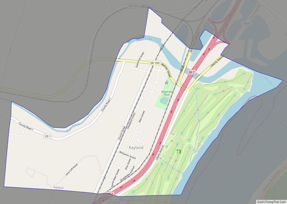
Map of Ravenna city, Ohio

Map of Ravenna city, Ohio

Ravenna is a city in and the county seat of Portage County, Ohio, United States. The population was 11,323 in the 2020 census. It is located 15 miles (24 km) east of Akron. Formed from portions of Ravenna Township in the Connecticut Western Reserve, Ravenna was founded in 1799 and is named after the city of … Read more

Map of Rarden village

Map of Rarden village

Rarden is a village in Scioto County, Ohio, United States. The population was 159 at the 2010 census. Rarden village overview: Name: Rarden village LSAD Code: 47 LSAD Description: village (suffix) State: Ohio County: Scioto County Elevation: 620 ft (189 m) Total Area: 0.21 sq mi (0.55 km²) Land Area: 0.21 sq mi (0.55 km²) Water Area: 0.00 sq mi (0.00 km²) Total Population: 146 Population … Read more

Map of Radnor CDP

Map of Radnor CDP

Radnor is an unincorporated community and census-designated place (CDP) in central Radnor Township, Delaware County, Ohio, United States. As of the 2010 census it had a population of 201. Radnor has a post office with the ZIP code of 43066. It lies along State Route 203 at its intersection with Radnor Road. Radnor CDP overview: … Read more

Map of Racine village, Ohio

Map of Racine village, Ohio

Racine is a village in Meigs County, Ohio, United States, along the Ohio River. The population was 683 at the 2020 census. Racine village overview: Name: Racine village LSAD Code: 47 LSAD Description: village (suffix) State: Ohio County: Meigs County Elevation: 577 ft (176 m) Total Area: 0.56 sq mi (1.45 km²) Land Area: 0.56 sq mi (1.45 km²) Water Area: 0.00 sq mi (0.00 km²) … Read more

Map of Quincy village, Ohio

Map of Quincy village, Ohio

Quincy is a village in Logan County, Ohio, United States. The population was 502 at the 2020 census. Quincy village overview: Name: Quincy village LSAD Code: 47 LSAD Description: village (suffix) State: Ohio County: Logan County Elevation: 1,053 ft (321 m) Total Area: 1.12 sq mi (2.90 km²) Land Area: 1.12 sq mi (2.90 km²) Water Area: 0.00 sq mi (0.00 km²) Total Population: 536 Population … Read more

Map of Reynoldsburg city

Map of Reynoldsburg city

Reynoldsburg is a city in Fairfield, Franklin, and Licking counties in the U.S. state of Ohio. It is a suburban community in the Columbus, Ohio metropolitan area. The population was 41,076 at the 2020 census. Reynoldsburg city overview: Name: Reynoldsburg city LSAD Code: 25 LSAD Description: city (suffix) State: Ohio County: Fairfield County, Franklin County, … Read more

Map of Republic village, Ohio

Map of Republic village, Ohio

Republic is a village in Seneca County, Ohio, United States. The population was 549 at the 2010 census. Republic village overview: Name: Republic village LSAD Code: 47 LSAD Description: village (suffix) State: Ohio County: Seneca County Elevation: 879 ft (268 m) Total Area: 0.86 sq mi (2.23 km²) Land Area: 0.86 sq mi (2.23 km²) Water Area: 0.00 sq mi (0.00 km²) Total Population: 556 Population … Read more

Map of Reno CDP, Ohio

Map of Reno CDP, Ohio

Reno is a census-designated place in southern Marietta Township, Washington County, Ohio, United States. It has a post office with the ZIP code 45773. It is located on the Ohio River a short distance below the county seat of Marietta. State Route 7 forms its main street. Reno CDP overview: Name: Reno CDP LSAD Code: … Read more

Map of Rendville village

Map of Rendville village

Rendville is a village in Perry County, Ohio, United States. It is an old mining town in southeastern Appalachian Ohio. The population was 28 at the 2020 census, making it the smallest incorporated community in Ohio. Rendville village overview: Name: Rendville village LSAD Code: 47 LSAD Description: village (suffix) State: Ohio County: Perry County Elevation: … Read more

Map of Remington CDP, Ohio

Map of Remington CDP, Ohio

Remington is a small hamlet and census-designated place (CDP) in Hamilton County, Ohio, United States. It is adjacent to Loveland, Indian Hill, and Camp Dennison and is considered part of the Greater Cincinnati area. It is included in the Indian Hill Exempted Village School District. The population of Remington was 368 at the 2020 census. … Read more

Map of Richville CDP, Ohio

Map of Richville CDP, Ohio

Richville is an unincorporated community and census-designated places in southern Perry Township, Stark County, Ohio, United States. State Route 627 passes through the community. The community is part of the Canton–Massillon Metropolitan Statistical Area. Richville was laid out in 1836. A post office was established at Richville in 1872, and remained in operation until 1902. … Read more

Map of Richmond village, Ohio

Map of Richmond village, Ohio

Richmond is a village in central Jefferson County, Ohio, United States. The population was 412 at the 2020 census. It is part of the Weirton–Steubenville metropolitan area. Richmond village overview: Name: Richmond village LSAD Code: 47 LSAD Description: village (suffix) State: Ohio County: Jefferson County Elevation: 1,243 ft (379 m) Total Area: 0.55 sq mi (1.43 km²) Land Area: 0.55 sq mi … Read more