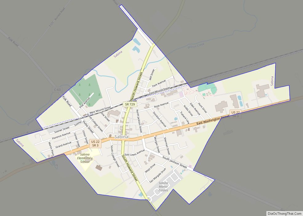
Map of Russia village
Russia (/ˈruːʃi/ ROO-shee) is a village in Loramie Township, Shelby County, Ohio, United States. The population was 640 at the 2010 census. Russia village overview: Name: Russia village LSAD Code: 47 LSAD Description: village (suffix) State: Ohio County: Shelby County Elevation: 970 ft (300 m) Total Area: 0.88 sq mi (2.27 km²) Land Area: 0.87 sq mi (2.24 km²) Water Area: 0.01 sq mi (0.02 km²) ... Read more
Map of Russia village
Map of Russellville village, Ohio
Russellville is a village in Jefferson Township, Brown County, Ohio, United States. The population was 561 at the 2010 census. Russellville village overview: Name: Russellville village LSAD Code: 47 LSAD Description: village (suffix) State: Ohio County: Brown County Elevation: 961 ft (293 m) Total Area: 0.73 sq mi (1.89 km²) Land Area: 0.73 sq mi (1.89 km²) Water Area: 0.00 sq mi (0.00 km²) Total Population: ... Read more
Map of Russellville village, Ohio
Map of Russells Point village
Russells Point is a village located in northwest Logan County, Ohio, United States. The population was 1,391 at the 2010 census. It is situated on Indian Lake, which had long been a popular summer resort destination. Russells Point village overview: Name: Russells Point village LSAD Code: 47 LSAD Description: village (suffix) State: Ohio County: Logan ... Read more
Map of Russells Point village
Map of Rushville village, Ohio
Rushville is a village in Fairfield County, Ohio, United States. The population was 302 at the 2010 census. Much of the village is listed on the National Register of Historic Places as the Rushville Historic District. Rushville takes its name from Little Rush Creek, which runs between the villages of Rushville and West Rushville. The ... Read more
Map of Rushville village, Ohio
Map of Rushsylvania village
Rushsylvania is a village located in Logan County, Ohio, United States. The population was 516 at the 2010 census. A branch of the Logan County District Library serves the Rushsylvania community. Rushsylvania village overview: Name: Rushsylvania village LSAD Code: 47 LSAD Description: village (suffix) State: Ohio County: Logan County Elevation: 1,237 ft (377 m) Total Area: 0.79 sq mi ... Read more
Map of Rushsylvania village
Map of Salesville CDP, Ohio
Salesville is a census-designated place and former village in Guernsey County, Ohio, United States. As of the 2020 census, the population was 123, down from 129 at the 2010 census. Its residents voted for dissolution in 2016. Salesville CDP overview: Name: Salesville CDP LSAD Code: 57 LSAD Description: CDP (suffix) State: Ohio County: Guernsey County ... Read more
Map of Salesville CDP, Ohio
Map of Salem city, Ohio
Salem is the largest city in Columbiana County, Ohio, with a small district in southern Mahoning County. At the 2020 census, the city’s population was 11,915. It is the principal city of the Salem micropolitan area, which includes all of Columbiana County. It lies about 18 miles (29 km) southwest of Youngstown, 28 miles (45 km) east ... Read more
Map of Salem city, Ohio
Map of Scott village, Ohio
Scott is a village in Paulding and Van Wert counties in the U.S. state of Ohio. The population was 286 at the 2010 census. The Van Wert County portion of Scott is part of the Van Wert Micropolitan Statistical Area. Scott village overview: Name: Scott village LSAD Code: 47 LSAD Description: village (suffix) State: Ohio ... Read more
Map of Scott village, Ohio
Map of Sciotodale CDP
Sciotodale is a census-designated place (CDP) in Scioto County, Ohio, United States. The population was 1,081 at the 2010 census. Sciotodale CDP overview: Name: Sciotodale CDP LSAD Code: 57 LSAD Description: CDP (suffix) State: Ohio County: Scioto County Elevation: 597 ft (182 m) Total Area: 1.94 sq mi (5.02 km²) Land Area: 1.93 sq mi (5.00 km²) Water Area: 0.01 sq mi (0.01 km²) Total Population: ... Read more
Map of Sciotodale CDP
Map of Scio village, Ohio
Scio (/saɪˈoʊ/ SY-oh) is a village in northern Harrison County, Ohio, United States. The population was 673 at the 2020 census. Scio village overview: Name: Scio village LSAD Code: 47 LSAD Description: village (suffix) State: Ohio County: Harrison County Elevation: 991 ft (302 m) Total Area: 0.56 sq mi (1.44 km²) Land Area: 0.56 sq mi (1.44 km²) Water Area: 0.00 sq mi (0.00 km²) Total ... Read more
Map of Scio village, Ohio
Map of Sawyerwood CDP
Sawyerwood is a census-designated place in Summit County, in the U.S. state of Ohio. Sawyerwood CDP overview: Name: Sawyerwood CDP LSAD Code: 57 LSAD Description: CDP (suffix) State: Ohio County: Summit County Total Area: 1.00 sq mi (2.58 km²) Land Area: 0.74 sq mi (1.91 km²) Water Area: 0.26 sq mi (0.67 km²) Total Population: 1,382 Population Density: 1,872.63/sq mi (723.08/km²) FIPS code: 3970618 Online ... Read more
Map of Sawyerwood CDP
Map of Savannah village, Ohio
Savannah is a village in Ashland County, Ohio, United States. The population was 329 at the 2020 census. Savannah village overview: Name: Savannah village LSAD Code: 47 LSAD Description: village (suffix) State: Ohio County: Ashland County Elevation: 1,099 ft (335 m) Total Area: 0.57 sq mi (1.47 km²) Land Area: 0.56 sq mi (1.45 km²) Water Area: 0.01 sq mi (0.02 km²) Total Population: 329 Population ... Read more
Map of Savannah village, Ohio