Map of Tiffin city, Ohio

Map of Tiffin city, Ohio

Tiffin is a city in and the county seat of Seneca County, Ohio, United States. Developed along the Sandusky River, which flows to Lake Erie, Tiffin is about 55 miles southeast of Toledo. The population was 17,963 at the 2010 census. The National Arbor Day Foundation has designated Tiffin as a Tree City USA. It … Read more

Map of Thurston village, Ohio

Map of Thurston village, Ohio

Thurston is a village in Fairfield County, Ohio, United States. The population was 604 at the 2010 census. Thurston village overview: Name: Thurston village LSAD Code: 47 LSAD Description: village (suffix) State: Ohio County: Fairfield County Elevation: 883 ft (269 m) Total Area: 0.40 sq mi (1.05 km²) Land Area: 0.40 sq mi (1.05 km²) Water Area: 0.00 sq mi (0.00 km²) Total Population: 603 Population … Read more

Map of Thornville village

Map of Thornville village

Thornville is a village in Perry County, Ohio, United States. It is 20 miles (32 km) north of the county seat of New Lexington. The village had a population of 1,087 as of the 2020 census. Thornville village overview: Name: Thornville village LSAD Code: 47 LSAD Description: village (suffix) State: Ohio County: Perry County Elevation: 1,030 ft … Read more

Map of Thornport CDP

Map of Thornport CDP

Thornport is a census-designated place in Perry County, in the U.S. state of Ohio. It is 2 miles north of Thornville and 22 miles north of the county seat of New Lexington. Thornport CDP overview: Name: Thornport CDP LSAD Code: 57 LSAD Description: CDP (suffix) State: Ohio County: Perry County FIPS code: 3976666 Online Interactive … Read more

Map of The Village of Indian Hill city

Map of The Village of Indian Hill city

The Village of Indian Hill is a city in Hamilton County, Ohio, United States, and an affluent suburb of the Greater Cincinnati area. The population was 6,087 at the 2020 census. Prior to 1970, Indian Hill was incorporated as a village, but under Ohio law became designated as a city once its population was verified … Read more

Map of The Plains CDP

Map of The Plains CDP, Ohio

The Plains is a census-designated place (CDP) in Athens County, Ohio, United States. The population was 3,140 at the 2020 census. The Plains CDP overview: Name: The Plains CDP LSAD Code: 57 LSAD Description: CDP (suffix) State: Ohio County: Athens County Elevation: 715 ft (218 m) Total Area: 2.29 sq mi (5.92 km²) Land Area: 2.28 sq mi (5.90 km²) Water Area: 0.01 sq mi … Read more

Map of Tippecanoe CDP

Map of Tippecanoe CDP

Tippecanoe is an unincorporated community and census-designated place (CDP) in central Washington Township, Harrison County, Ohio, United States. It is located along State Route 800 in the valley of Stillwater Creek, a north-flowing tributary of the Tuscarawas River. it had a post office until 2011 with the ZIP code 44699. The population was 121 at … Read more

Map of Tipp City city

Map of Tipp City

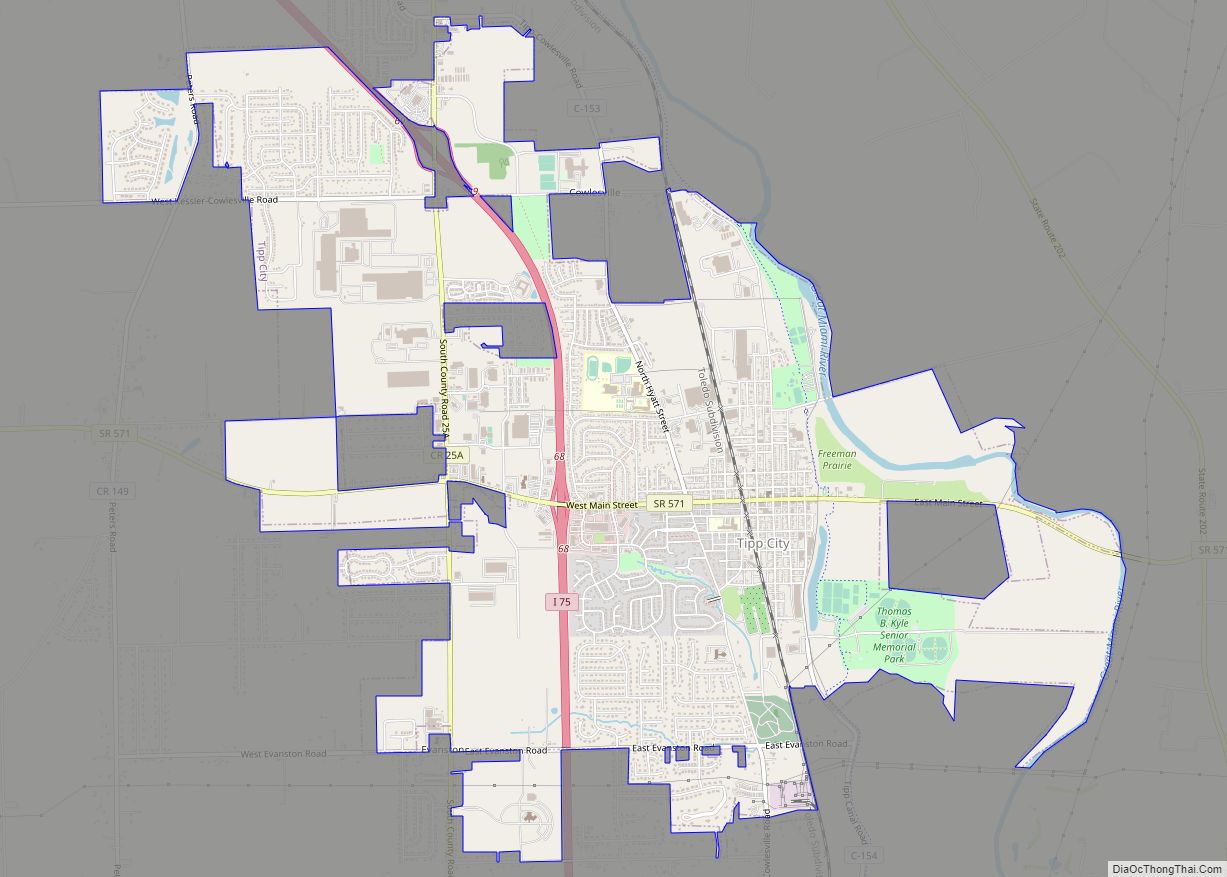
Tipp City is a city in Miami County, Ohio, United States, just outside Dayton. The population was 9,689 at the 2010 census. Originally known as Tippecanoe, and then Tippecanoe City, it was renamed to Tipp City in 1938 because another town in Ohio was likewise named Tippecanoe. The city lies in the Miami Valley and … Read more

Map of Timberlake village

Map of Timberlake village, Ohio

Timberlake is a village in Lake County, Ohio, United States. The population was 629 at the 2020 census. Timberlake village overview: Name: Timberlake village LSAD Code: 47 LSAD Description: village (suffix) State: Ohio County: Lake County Incorporated: 1947 Elevation: 620 ft (189 m) Total Area: 0.21 sq mi (0.55 km²) Land Area: 0.21 sq mi (0.55 km²) Water Area: 0.00 sq mi (0.00 km²) Total Population: … Read more

Map of Tuppers Plains CDP

Map of Tuppers Plains CDP

Tuppers Plains is a census-designated place on the boundary of the Olive and Orange townships of Meigs County, Ohio, United States. It includes the small town of Tuppers Plains for which it is named. Tuppers Plains CDP overview: Name: Tuppers Plains CDP LSAD Code: 57 LSAD Description: CDP (suffix) State: Ohio County: Meigs County FIPS … Read more

Map of Troy city, Ohio

Map of Troy city, Ohio

Troy is a city in and the county seat of Miami County, Ohio, United States,19 miles (31 km) north of Dayton. The population was 26,305 at the 2020 census, making it Miami County’s largest city and Ohio’s 55th-largest; it is part of the Dayton Metropolitan Statistical Area. Troy city overview: Name: Troy city LSAD Code: 25 … Read more

Map of Trotwood city

Map of Trotwood city

Trotwood is a city in Montgomery County, Ohio, United States and is a suburb of Dayton. The population was 23,070 at the 2020 census. It is part of the Dayton Metropolitan Statistical Area. The city is served by the Trotwood-Madison City School District. Trotwood city overview: Name: Trotwood city LSAD Code: 25 LSAD Description: city … Read more