Map of Uhrichsville city
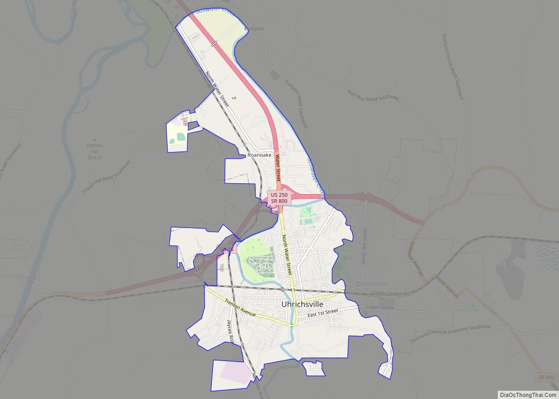
Uhrichsville(/ˈɜːrɪksˌvɪl/ UR-iks-vil) is a city in Tuscarawas County, Ohio, United States. The population was 5,413 at the 2010 census. Claymont City School District is the major education provider for the city of Uhrichsville and for the village of Dennison, Ohio. The Twin cities is a nickname used to describe Uhrichsville and Dennison because they are ... Read more
Map of Uhrichsville city
Map of Twinsburg city
Twinsburg is a suburban city in Summit County, Ohio, United States, located about halfway between Akron and Cleveland. The population was 19,248 as of the 2020 census. It is part of the Akron metropolitan area. Twinsburg city overview: Name: Twinsburg city LSAD Code: 25 LSAD Description: city (suffix) State: Ohio County: Summit County Elevation: 1,001 ft ... Read more
Map of Twinsburg city
Map of Twinsburg Heights CDP
Twinsburg Heights is a census-designated place (CDP) in Summit County, Ohio, United States, composed of 14 streets in Twinsburg, Ohio. The population was 925 at the 2010 census. Twinsburg Heights CDP overview: Name: Twinsburg Heights CDP LSAD Code: 57 LSAD Description: CDP (suffix) State: Ohio County: Summit County Total Area: 0.29 sq mi (0.74 km²) Land Area: 0.29 sq mi ... Read more
Map of Twinsburg Heights CDP
Map of Tuscarawas village
Tuscarawas (/ˌtʌskəˈrɑːwəs/ TUS-kə-RAH-wəs), originally Trenton, is a village in Tuscarawas County, Ohio, United States. The population was 1,056 at the 2010 census. Tuscarawas village overview: Name: Tuscarawas village LSAD Code: 47 LSAD Description: village (suffix) State: Ohio County: Tuscarawas County Elevation: 850 ft (259 m) Total Area: 0.75 sq mi (1.94 km²) Land Area: 0.73 sq mi (1.90 km²) Water Area: 0.01 sq mi (0.04 km²) ... Read more
Map of Tuscarawas village
Map of Turpin Hills CDP
Turpin Hills is a census-designated place (CDP) outside of Anderson Township, Hamilton County, Ohio, United States. The population was 5,162 at the 2020 census. Turpin Hills CDP overview: Name: Turpin Hills CDP LSAD Code: 57 LSAD Description: CDP (suffix) State: Ohio County: Hamilton County Elevation: 650 ft (198 m) Total Area: 2.97 sq mi (7.69 km²) Land Area: 2.97 sq mi (7.68 km²) ... Read more
Map of Turpin Hills CDP
Map of University Heights city, Ohio
University Heights is a city in Cuyahoga County, Ohio, United States. It borders Beachwood to the east, Cleveland Heights to the west, South Euclid to the north and Shaker Heights to the south. The population was 13,914 as of the 2020 Census. University Heights is nicknamed the “City of Beautiful Homes.” University Heights is closely ... Read more
Map of University Heights city, Ohio
Map of Valleyview village
Valleyview is a village in Franklin County, Ohio, United States. The population was 669 at the 2020 census. Valleyview village overview: Name: Valleyview village LSAD Code: 47 LSAD Description: village (suffix) State: Ohio County: Franklin County Total Area: 0.15 sq mi (0.38 km²) Land Area: 0.14 sq mi (0.37 km²) Water Area: 0.00 sq mi (0.01 km²) Total Population: 669 Population Density: 4,678.32/sq mi (1,810.53/km²) ... Read more
Map of Valleyview village
Map of Valley View village, Ohio
Valley View is a village in Cuyahoga County, Ohio, United States. The population was 2,034 at the 2010 census. It is a suburb of Cleveland with a town council form of government. It is part of a school district that also includes nearby Cuyahoga Heights and Brooklyn Heights. Its name refers to the Cuyahoga River ... Read more
Map of Valley View village, Ohio
Map of Valley Hi village
Valley Hi is a village in Logan County, Ohio, United States. The population was 212 at the 2010 census. The village is located nearby U.S. Route 33 and is about an hour northwest of Columbus. The village lies mostly in Jefferson Township, but its southernmost portion extends into Monroe Township. Valley Hi village overview: Name: ... Read more
Map of Valley Hi village
Map of Valley City CDP, Ohio
Valley City is an unincorporated community in central Liverpool Township, Medina County, Ohio, United States. The west branch of the Rocky River and Plum Creek flow near Valley City from south to north. It is located at intersection of State Routes 252 and 303 in the northwest corner of Medina County. Settled in 1810, the ... Read more
Map of Valley City CDP, Ohio
Map of Utica village, Ohio
Utica is a village in Knox and Licking counties in the U.S. state of Ohio, along the North Fork of the Licking River. The population was 2,132 at the 2010 census. The village is home to the general headquarters (HQ) of the Velvet Ice Cream Company at the Ye Olde Mill just south of the ... Read more
Map of Utica village, Ohio
Map of Urbancrest village
Urbancrest is a village in Franklin County, Ohio, United States. The population was 1,031 at the 2020 census. Urbancrest is in the South-Western City Schools District. Urbancrest village overview: Name: Urbancrest village LSAD Code: 47 LSAD Description: village (suffix) State: Ohio County: Franklin County Elevation: 840 ft (256 m) Total Area: 0.59 sq mi (1.52 km²) Land Area: 0.59 sq mi (1.52 km²) ... Read more
Map of Urbancrest village