Map of Loretto CDP, Nebraska
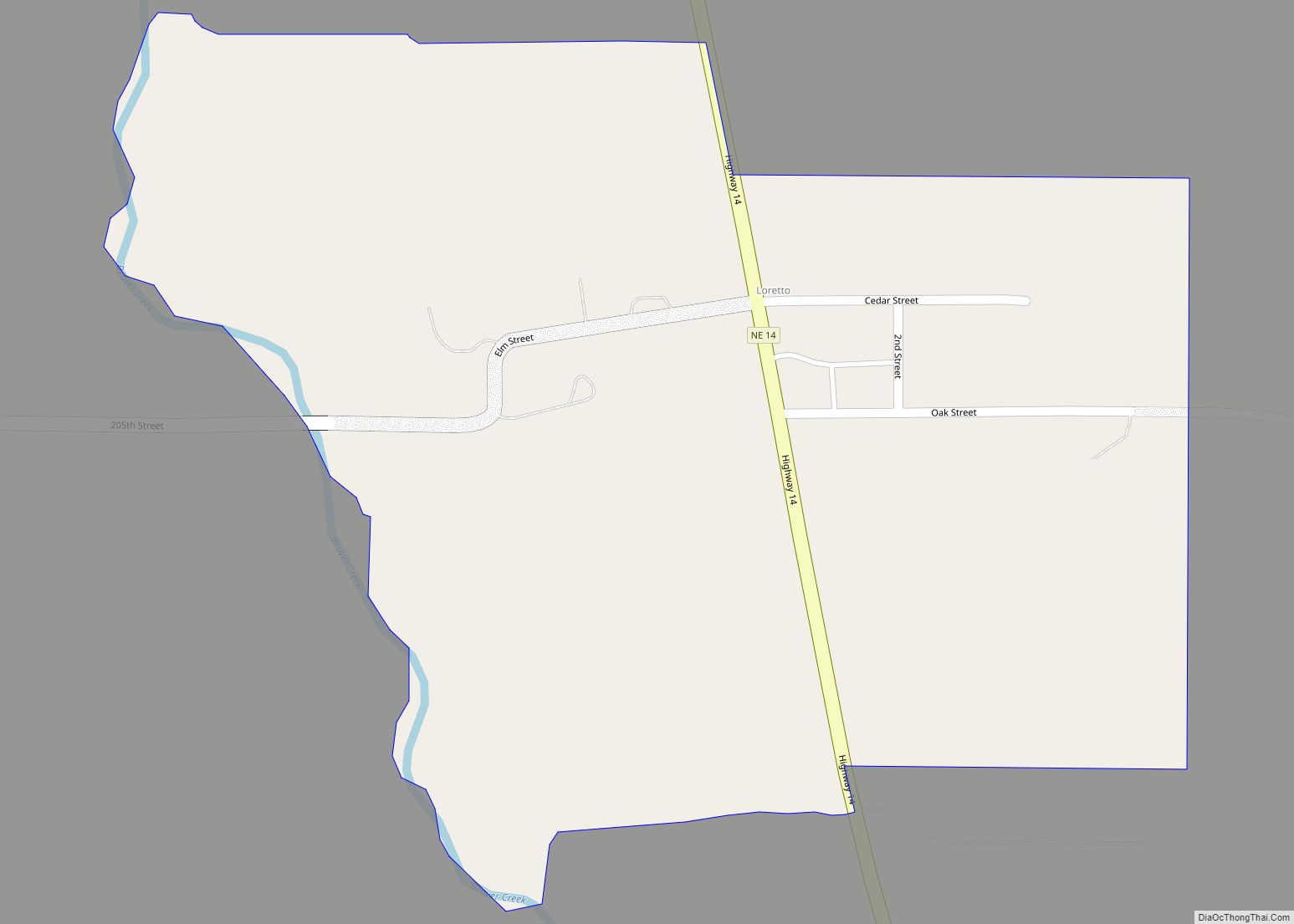
Loretto is an unincorporated community and census-designated place in Boone County, Nebraska, United States. As of the 2010 census, the community had a population of 42. Loretto CDP overview: Name: Loretto CDP LSAD Code: 57 LSAD Description: CDP (suffix) State: Nebraska County: Boone County Total Area: 0.28 sq mi (0.73 km²) Land Area: 0.28 sq mi (0.73 km²) Water Area: 0.00 sq mi ... Read more
Map of Loretto CDP, Nebraska
Map of Lorenzo CDP, Nebraska
Lorenzo is an unincorporated community and census-designated place in Cheyenne County, Nebraska, United States.< As of the 2010 census, it had a population of 58. Lorenzo is located on Nebraska Highway 19, 10 miles (16 km) southwest of Sidney, the county seat, and 3.5 miles (5.6 km) north of the Colorado border. Lorenzo CDP overview: Name: Lorenzo ... Read more
Map of Lorenzo CDP, Nebraska
Map of Loomis village, Nebraska
Loomis is a village in Phelps County, Nebraska, United States. The population was 383 at the 2010 census. Loomis village overview: Name: Loomis village LSAD Code: 47 LSAD Description: village (suffix) State: Nebraska County: Phelps County Elevation: 2,425 ft (739 m) Total Area: 0.33 sq mi (0.85 km²) Land Area: 0.33 sq mi (0.85 km²) Water Area: 0.00 sq mi (0.00 km²) Total Population: 420 Population ... Read more
Map of Loomis village, Nebraska
Map of Lyons city, Nebraska
Lyons is a city in Burt County, Nebraska, United States. The population was 851 in the 2010 census. The city is named after its founder. Lyons city overview: Name: Lyons city LSAD Code: 25 LSAD Description: city (suffix) State: Nebraska County: Burt County Elevation: 1,293 ft (394 m) Total Area: 0.69 sq mi (1.79 km²) Land Area: 0.68 sq mi (1.77 km²) Water ... Read more
Map of Lyons city, Nebraska
Map of Martinsburg village, Nebraska
Martinsburg is a village in Dixon County, Nebraska, United States. It is part of the Sioux City, IA–NE–SD Metropolitan Statistical Area. The population was 94 at the 2010 census. Martinsburg village overview: Name: Martinsburg village LSAD Code: 47 LSAD Description: village (suffix) State: Nebraska County: Dixon County Elevation: 1,253 ft (382 m) Total Area: 0.10 sq mi (0.27 km²) Land ... Read more
Map of Martinsburg village, Nebraska
Map of Martin CDP, Nebraska
Martin is an unincorporated community and census-designated place in Keith County, Nebraska, United States. As of the 2010 census it had a population of 92. Martin Bay is one of the most popular recreation areas on Lake McConaughy. Martin CDP overview: Name: Martin CDP LSAD Code: 57 LSAD Description: CDP (suffix) State: Nebraska County: Keith ... Read more
Map of Martin CDP, Nebraska
Map of Marquette village, Nebraska
Marquette is a village in Hamilton County, Nebraska, United States. The population was 229 at the 2010 census. Marquette village overview: Name: Marquette village LSAD Code: 47 LSAD Description: village (suffix) State: Nebraska County: Hamilton County Elevation: 1,818 ft (554 m) Total Area: 0.21 sq mi (0.54 km²) Land Area: 0.21 sq mi (0.54 km²) Water Area: 0.00 sq mi (0.00 km²) Total Population: 236 Population ... Read more
Map of Marquette village, Nebraska
Map of Manley village
Manley is a village in Cass County, Nebraska, United States. The population was 167 at the 2020 census. Manley village overview: Name: Manley village LSAD Code: 47 LSAD Description: village (suffix) State: Nebraska County: Cass County Elevation: 1,293 ft (394 m) Total Area: 0.11 sq mi (0.29 km²) Land Area: 0.11 sq mi (0.29 km²) Water Area: 0.00 sq mi (0.00 km²) Total Population: 167 Population ... Read more
Map of Manley village
Map of Malmo village
Malmo is a village in Saunders County, Nebraska, United States. The population was 94 at the 2020 census. Malmo village overview: Name: Malmo village LSAD Code: 47 LSAD Description: village (suffix) State: Nebraska County: Saunders County Elevation: 1,260 ft (380 m) Total Area: 0.14 sq mi (0.35 km²) Land Area: 0.14 sq mi (0.35 km²) Water Area: 0.00 sq mi (0.00 km²) Total Population: 94 Population ... Read more
Map of Malmo village
Map of Malcolm village, Nebraska
Malcolm is a village in Lancaster County, Nebraska, United States. It is part of the Lincoln, Nebraska Metropolitan Statistical Area. The population was 457 at the 2020 census. Malcolm village overview: Name: Malcolm village LSAD Code: 47 LSAD Description: village (suffix) State: Nebraska County: Lancaster County Elevation: 1,286 ft (392 m) Total Area: 0.15 sq mi (0.39 km²) Land Area: ... Read more
Map of Malcolm village, Nebraska
Map of Magnet village
Magnet is a village in Cedar County, Nebraska, United States. The population was 46 at the 2020 census. Magnet village overview: Name: Magnet village LSAD Code: 47 LSAD Description: village (suffix) State: Nebraska County: Cedar County Elevation: 1,827 ft (557 m) Total Area: 0.15 sq mi (0.39 km²) Land Area: 0.15 sq mi (0.39 km²) Water Area: 0.00 sq mi (0.00 km²) Total Population: 46 Population ... Read more
Map of Magnet village
Map of Madrid village, Nebraska
Madrid (/ˈmædrɪd/ ma-drid) is a village in Perkins County, Nebraska, United States. The population was 231 at the 2010 census. Madrid village overview: Name: Madrid village LSAD Code: 47 LSAD Description: village (suffix) State: Nebraska County: Perkins County Elevation: 3,301 ft (1,006 m) Total Area: 1.13 sq mi (2.93 km²) Land Area: 1.13 sq mi (2.93 km²) Water Area: 0.00 sq mi (0.00 km²) Total Population: ... Read more
Map of Madrid village, Nebraska