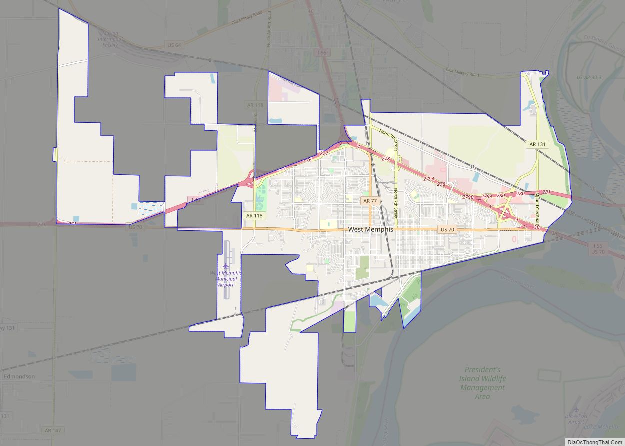
Map of West Fork city
West Fork is a city in Washington County, Arkansas, United States. The population is 2,331 at the 2020 census. It is part of the Northwest Arkansas region. West Fork city overview: Name: West Fork city LSAD Code: 25 LSAD Description: city (suffix) State: Arkansas County: Washington County Founded: 1848 Incorporated: May 18, 1885 Elevation: 1,362 ft ... Read more
Map of West Fork city
Map of West Crossett CDP
West Crossett is a census-designated place (CDP) in Ashley County, Arkansas, United States. Per the 2020 census, the population was 1,144. West Crossett CDP overview: Name: West Crossett CDP LSAD Code: 57 LSAD Description: CDP (suffix) State: Arkansas County: Ashley County Elevation: 151 ft (46 m) Total Area: 11.90 sq mi (30.83 km²) Land Area: 11.89 sq mi (30.80 km²) Water Area: 0.01 sq mi ... Read more
Map of West Crossett CDP
Map of Wheatley city
Wheatley is a town in southwest St. Francis County, Arkansas, United States. The population was 279 at the 2020 census, down from 355 in 2010. Wheatley city overview: Name: Wheatley city LSAD Code: 25 LSAD Description: city (suffix) State: Arkansas County: St. Francis County Elevation: 207 ft (63 m) Total Area: 3.07 sq mi (7.95 km²) Land Area: 3.07 sq mi (7.95 km²) ... Read more
Map of Wheatley city
Map of Western Grove town
Western Grove is a town in northeastern Newton County, Arkansas, United States. The population was 384 at the 2010 census. It is part of the Harrison Micropolitan Statistical Area. Western Grove town overview: Name: Western Grove town LSAD Code: 43 LSAD Description: town (suffix) State: Arkansas County: Newton County Elevation: 1,050 ft (320 m) Total Area: 1.08 sq mi ... Read more
Map of Western Grove town
Map of West Point town, Arkansas
West Point is a town in White County, Arkansas, United States. David Hamilton was mayor from “1972 except for two years he missed for cancer surgery,” according to an article in the Searcy, Arkansas newspaper The Daily Citizen (“Mayors bring politics, leadership to ground level” by Warren Watkins, 27 January 2007). “My great-grandfather landed at ... Read more
Map of West Point town, Arkansas
Map of Wickes town
Wickes is a city in Polk County, Arkansas, United States. The population was 754 at the 2010 census. Near Wickes is the Boggs Springs Youth Encampment of the American Baptist Association, a retreat of Missionary Baptist churches. Wickes has historic places such as the 100-year-old City Hall, and the Lighthouse Drive-in. Wickes town overview: Name: ... Read more
Map of Wickes town
Map of White Hall city, Arkansas
White Hall is a city in Washington Township, located in Jefferson County, Arkansas, United States. With a population of 5,526 in the 2010 census, it is included in the Pine Bluff Metropolitan Statistical Area and the greater Little Rock-North Little Rock-Pine Bluff Combined Statistical Area. White Hall is home to the Pine Bluff Arsenal. White ... Read more
Map of White Hall city, Arkansas
Map of Whelen Springs town
Whelen Springs is a town in Clark County, Arkansas, United States. The population was 92 at the 2010 census. From 1930 through 1939 the town thrived, being a main hub of operations for the then powerful Ozan Lumber Company. Whelen Springs town overview: Name: Whelen Springs town LSAD Code: 43 LSAD Description: town (suffix) State: ... Read more
Map of Whelen Springs town
Map of Williford town
Williford is a town in Sharp County, Arkansas, United States. The population was 70 in 2020 Williford town overview: Name: Williford town LSAD Code: 43 LSAD Description: town (suffix) State: Arkansas County: Sharp County Elevation: 331 ft (101 m) Total Area: 0.35 sq mi (0.91 km²) Land Area: 0.35 sq mi (0.91 km²) Water Area: 0.00 sq mi (0.00 km²) Total Population: 79 Population Density: 226.36/sq mi ... Read more
Map of Williford town
Map of Wiederkehr Village city
Wiederkehr Village is a city in Franklin County, Arkansas, United States. It is part of the Fort Smith, Arkansas–Oklahoma Metropolitan Statistical Area. The population was 38 at the 2010 census. It is named after Swiss winemaker Johann Andreas Wiederkehr, who immigrated to the area in 1880. Wiederkehr Village city overview: Name: Wiederkehr Village city LSAD ... Read more
Map of Wiederkehr Village city
Map of Widener town
Widener is a town in St. Francis County, Arkansas, United States. The population was 212 at the 2020 census, a decline from 273 in 2010. Widener town overview: Name: Widener town LSAD Code: 43 LSAD Description: town (suffix) State: Arkansas County: St. Francis County Elevation: 207 ft (63 m) Total Area: 0.55 sq mi (1.41 km²) Land Area: 0.55 sq mi (1.41 km²) ... Read more
Map of Widener town
Map of Willisville town, Arkansas
Willisville is a town in Nevada County, Arkansas, United States. The population was 148 at the 2020 census. It is part of the Hope Micropolitan Statistical Area. Willisville town overview: Name: Willisville town LSAD Code: 43 LSAD Description: town (suffix) State: Arkansas County: Nevada County Elevation: 361 ft (110 m) Total Area: 1.61 sq mi (4.17 km²) Land Area: 1.60 sq mi ... Read more
Map of Willisville town, Arkansas