Map of Cumberland village, Ohio
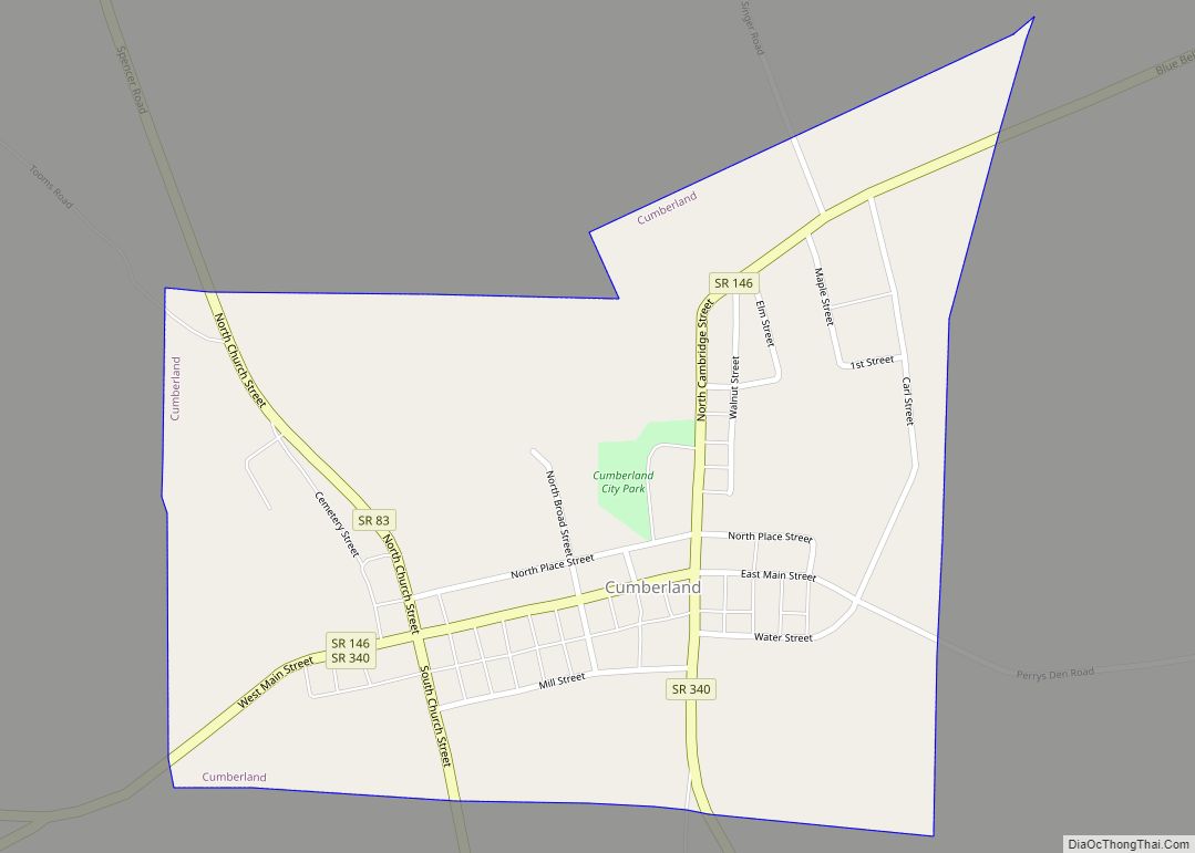
Cumberland is a village in Guernsey County, Ohio, United States. It is seventy miles east of Columbus. The population was 367 at the 2010 census. Cumberland village overview: Name: Cumberland village LSAD Code: 47 LSAD Description: village (suffix) State: Ohio County: Guernsey County Elevation: 843 ft (257 m) Total Area: 0.49 sq mi (1.26 km²) Land Area: 0.49 sq mi (1.26 km²) Water ... Read more
Map of Cumberland village, Ohio
Map of Crystal Rock CDP
Crystal Rock is an unincorporated community and census-designated place in Erie County, Ohio, United States. As of the 2010 census it had a population of 176. It is located within Margaretta Township. Crystal Rock CDP overview: Name: Crystal Rock CDP LSAD Code: 57 LSAD Description: CDP (suffix) State: Ohio County: Erie County Elevation: 581 ft (177 m) ... Read more
Map of Crystal Rock CDP
Map of Crystal Lakes CDP, Ohio
Crystal Lakes is a census-designated place (CDP) in Clark County, Ohio, United States. The population was 1,483 at the 2010 census. It is part of the Springfield, Ohio Metropolitan Statistical Area. Crystal Lakes CDP overview: Name: Crystal Lakes CDP LSAD Code: 57 LSAD Description: CDP (suffix) State: Ohio County: Clark County Elevation: 850 ft (259 m) Total ... Read more
Map of Crystal Lakes CDP, Ohio
Map of Crown City village
Crown City is a village in Gallia County, Ohio, United States, along the Ohio River. The population was 424 at the 2020 census. Crown City village overview: Name: Crown City village LSAD Code: 47 LSAD Description: village (suffix) State: Ohio County: Gallia County Elevation: 571 ft (174 m) Total Area: 1.20 sq mi (3.10 km²) Land Area: 1.16 sq mi (3.01 km²) Water ... Read more
Map of Crown City village
Map of Darbyville village
Darbyville is a village in Pickaway County, Ohio, United States. The population was 222 at the 2010 census. Darbyville village overview: Name: Darbyville village LSAD Code: 47 LSAD Description: village (suffix) State: Ohio County: Pickaway County Elevation: 745 ft (227 m) Total Area: 0.54 sq mi (1.39 km²) Land Area: 0.52 sq mi (1.34 km²) Water Area: 0.02 sq mi (0.06 km²) Total Population: 186 Population ... Read more
Map of Darbyville village
Map of Darbydale CDP
Darbydale is an unincorporated community and census-designated place (CDP) in central Pleasant Township, Franklin County, Ohio, United States. It was an incorporated village until its disincorporation on December 27, 1985. As of the 2010 census, the population was 793. The community is located in the southwest part of Franklin County, on the north side of ... Read more
Map of Darbydale CDP
Map of Danville village, Ohio
Danville is a village in Knox County, Ohio, United States. The population was 1,044 at the 2010 census. Danville village overview: Name: Danville village LSAD Code: 47 LSAD Description: village (suffix) State: Ohio County: Knox County Elevation: 994 ft (303 m) Total Area: 0.60 sq mi (1.54 km²) Land Area: 0.59 sq mi (1.53 km²) Water Area: 0.01 sq mi (0.01 km²) Total Population: 1,019 Population ... Read more
Map of Danville village, Ohio
Map of Damascus CDP, Ohio
Damascus is an unincorporated community and census-designated place in southern Mahoning and northern Columbiana counties in the U.S. state of Ohio. As of the 2020 census, it had a population of 418. The community lies at the intersection of U.S. Route 62 and State Routes 173 and 534. The community is located in southwestern Goshen ... Read more
Map of Damascus CDP, Ohio
Map of Dalton village, Ohio
Dalton is a village in Wayne County, Ohio, United States. The 2010 census indicated a population of 1,830. Dalton village overview: Name: Dalton village LSAD Code: 47 LSAD Description: village (suffix) State: Ohio County: Wayne County Elevation: 1,102 ft (336 m) Total Area: 1.67 sq mi (4.33 km²) Land Area: 1.67 sq mi (4.33 km²) Water Area: 0.00 sq mi (0.00 km²) Total Population: 1,927 Population ... Read more
Map of Dalton village, Ohio
Map of Deersville village
Deersville is a village in Harrison County, Ohio, United States. The population was 69 at the 2020 census. The Deersville Historic District is located along Main Street. Deersville village overview: Name: Deersville village LSAD Code: 47 LSAD Description: village (suffix) State: Ohio County: Harrison County Elevation: 1,234 ft (376 m) Total Area: 0.34 sq mi (0.89 km²) Land Area: 0.34 sq mi ... Read more
Map of Deersville village
Map of Deer Park city, Ohio
Deer Park is a city in Hamilton County, Ohio, United States. It is a suburb of Cincinnati. The population was 5,432 at the 2020 census. It is part of the Cincinnati metropolitan area. Deer Park city overview: Name: Deer Park city LSAD Code: 25 LSAD Description: city (suffix) State: Ohio County: Hamilton County Elevation: 869 ft ... Read more
Map of Deer Park city, Ohio
Map of De Graff village, Ohio
De Graff is a village located in Logan County, Ohio, United States. The population was 1,285 at the 2010 census. De Graff village overview: Name: De Graff village LSAD Code: 47 LSAD Description: village (suffix) State: Ohio County: Logan County Elevation: 1,001 ft (305 m) Total Area: 1.00 sq mi (2.60 km²) Land Area: 1.00 sq mi (2.60 km²) Water Area: 0.00 sq mi (0.00 km²) ... Read more
Map of De Graff village, Ohio