Map of Cornville CDP
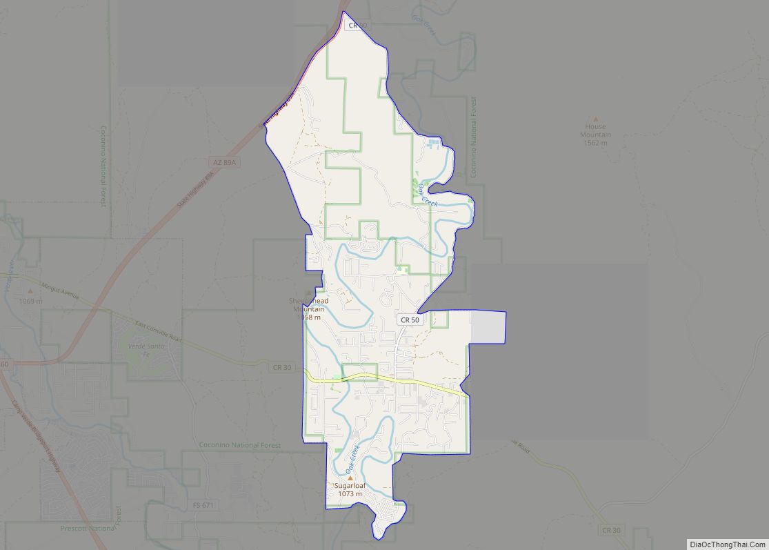
Cornville is a census-designated place (CDP) in Yavapai County, Arizona, United States. The population as of the 2010 United States Census was 3,280, down from 3,335 at the 2000 census. For statistical purposes, the United States Census Bureau has defined Cornville as a CDP that includes the unincorporated communities of Cornville and Page Springs. Cornville ... Read more
Map of Cornville CDP
Map of Cornfields CDP
Cornfields is a chapter of the Navajo Nation and a census-designated place (CDP) in Apache County, Arizona, United States. The population was 255 at the 2010 census. Cornfields is part of the Fort Defiance Agency, of the Bureau of Indian Affairs; Ganado, AZ is the delegate seat for the district that encompasses the Jeddito, Cornfields, ... Read more
Map of Cornfields CDP
Map of Cowlic CDP
Cowlic or Kawulk (O’odham) name translates as “The Hill”, is a census-designated place (CDP) in Pima County, Arizona, United States. The population was 147 as of the 2020 census. It is located on the Tohono O’odham Nation reservation. Cowlic CDP overview: Name: Cowlic CDP LSAD Code: 57 LSAD Description: CDP (suffix) State: Arizona County: Pima ... Read more
Map of Cowlic CDP
Map of Cottonwood CDP, Arizona
Cottonwood is a census-designated place (CDP) in Apache County, Arizona, United States. The population was 226 at the 2010 census. Cottonwood CDP overview: Name: Cottonwood CDP LSAD Code: 57 LSAD Description: CDP (suffix) State: Arizona County: Apache County Elevation: 6,069 ft (1,850 m) Total Area: 0.16 sq mi (0.41 km²) Land Area: 0.16 sq mi (0.41 km²) Water Area: 0.00 sq mi (0.00 km²) Total Population: ... Read more
Map of Cottonwood CDP, Arizona
Map of Corona de Tucson CDP
Corona de Tucson is a census-designated place (CDP) in Pima County, Arizona, United States. The population was 9,240 at the 2020 census, an increase of 1036% from the 2000 population of 813. ZIP code 85641 is shared by Corona de Tucson and Vail. Corona de Tucson CDP overview: Name: Corona de Tucson CDP LSAD Code: ... Read more
Map of Corona de Tucson CDP
Map of Cutter CDP
Cutter is a census-designated place in Gila County in the U.S. state of Arizona. Cutter is located just off US Route 70, east of the city of Globe. The population as of the 2010 U.S. Census was 74. Cutter CDP overview: Name: Cutter CDP LSAD Code: 57 LSAD Description: CDP (suffix) State: Arizona County: Gila ... Read more
Map of Cutter CDP
Map of Crystal Beach CDP, Arizona
Crystal Beach is an unincorporated community and census-designated place (CDP) in Mohave County, Arizona, United States. The population was 250 at the 2020 census. Crystal Beach CDP overview: Name: Crystal Beach CDP LSAD Code: 57 LSAD Description: CDP (suffix) State: Arizona County: Mohave County Elevation: 518 ft (158 m) Total Area: 0.34 sq mi (0.88 km²) Land Area: 0.34 sq mi (0.88 km²) ... Read more
Map of Crystal Beach CDP, Arizona
Map of Crozier CDP
Crozier is an unincorporated community and census-designated place (CDP) in Mohave County, Arizona, United States. The population was 21 at the 2020 census. Crozier CDP overview: Name: Crozier CDP LSAD Code: 57 LSAD Description: CDP (suffix) State: Arizona County: Mohave County Elevation: 3,983 ft (1,214 m) Total Area: 1.05 sq mi (2.72 km²) Land Area: 1.05 sq mi (2.72 km²) Water Area: 0.00 sq mi ... Read more
Map of Crozier CDP
Map of Del Muerto CDP
Del Muerto is a census-designated place (CDP) in Apache County, Arizona, United States. The population was 329 at the 2010 census. Del Muerto CDP overview: Name: Del Muerto CDP LSAD Code: 57 LSAD Description: CDP (suffix) State: Arizona County: Apache County Elevation: 6,440 ft (1,960 m) Total Area: 1.19 sq mi (3.08 km²) Land Area: 1.19 sq mi (3.08 km²) Water Area: 0.00 sq mi ... Read more
Map of Del Muerto CDP
Map of Deer Creek CDP, Arizona
Deer Creek is a census-designated place in Gila County in the U.S. state of Arizona. Deer Creek is located almost directly between the community of Tonto Basin and the town of Payson near Arizona State Route 87. The population as of the 2010 U.S. Census was 216. Deer Creek CDP overview: Name: Deer Creek CDP ... Read more
Map of Deer Creek CDP, Arizona
Map of Dateland CDP
Dateland is both a CDP and a populated place in Yuma County, Arizona, United States. It is in an area well known for date palm dates. Dateland has the ZIP Code of 85333; in 2000, the population of the 85333 ZCTA was 852. The community is part of the Yuma Metropolitan Statistical Area. The Dateland ... Read more
Map of Dateland CDP
Map of Dewey-Humboldt town
Dewey–Humboldt is a town in Yavapai County, Arizona, United States. The population of the town was 3,894 according to the 2010 census. The Dewey–Humboldt area was a census-designated place (CDP) at the 2000 census, at which time its population was 6,295. Dewey-Humboldt town overview: Name: Dewey-Humboldt town LSAD Code: 43 LSAD Description: town (suffix) State: ... Read more
Map of Dewey-Humboldt town