Map of Lone Oak city, Texas
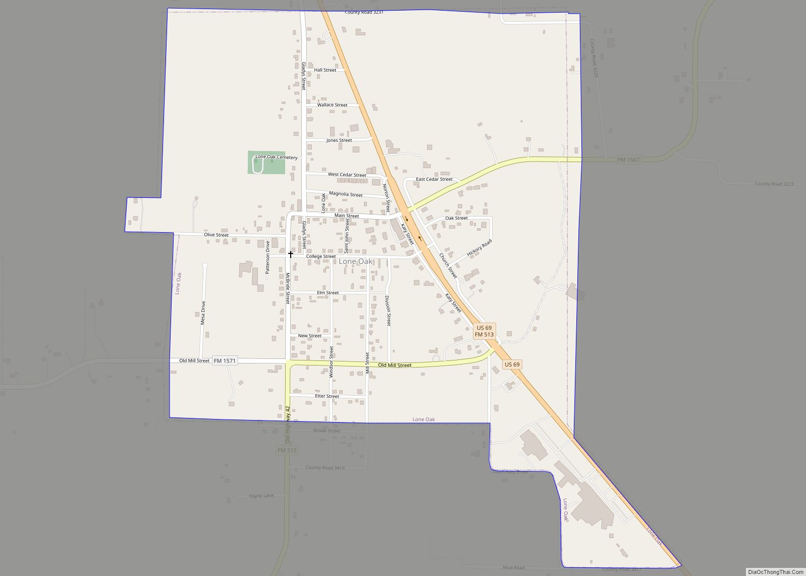
Lone Oak is a city in Hunt County, Texas, United States. The population was 598 at the 2010 census, up from 521 at the 2000 census. Lone Oak city overview: Name: Lone Oak city LSAD Code: 25 LSAD Description: city (suffix) State: Texas County: Hunt County Elevation: 564 ft (172 m) Total Area: 1.11 sq mi (2.88 km²) Land Area: ... Read more
Map of Lone Oak city, Texas
Map of Lometa city
Lometa (/loʊˈmiːtə/ loh-MEE-tə) is a city in Lampasas County, Texas, United States. The population was 856 at the 2010 census. It is part of the Killeen–Temple–Fort Hood metropolitan statistical area. Lometa city overview: Name: Lometa city LSAD Code: 25 LSAD Description: city (suffix) State: Texas County: Lampasas County Elevation: 1,493 ft (455 m) Total Area: 0.84 sq mi (2.17 km²) ... Read more
Map of Lometa city
Map of Los Arcos CDP
Los Arcos is a census-designated place (CDP) in Webb County, Texas, United States. This was a new CDP for the 2010 census with a population of 127. Los Arcos CDP overview: Name: Los Arcos CDP LSAD Code: 57 LSAD Description: CDP (suffix) State: Texas County: Webb County Elevation: 610 ft (190 m) Total Area: 0.2 sq mi (0.5 km²) Land ... Read more
Map of Los Arcos CDP
Map of Los Angeles CDP, Texas
Los Angeles is a census-designated place (CDP) in Willacy County, Texas, United States. The population was 121 at the 2010 census. Prior to the 2010 census, the CDP was known as Los Angeles Subdivision. Los Angeles CDP overview: Name: Los Angeles CDP LSAD Code: 57 LSAD Description: CDP (suffix) State: Texas County: Willacy County Elevation: ... Read more
Map of Los Angeles CDP, Texas
Map of Los Alvarez CDP
Los Alvarez is a census-designated place (CDP) in Starr County, Texas, United States. The population was 303 at the 2010 census down from 1,434 at the 2000 census. Los Alvarez CDP overview: Name: Los Alvarez CDP LSAD Code: 57 LSAD Description: CDP (suffix) State: Texas County: Starr County Elevation: 197 ft (60 m) Total Area: 0.1 sq mi (0.3 km²) ... Read more
Map of Los Alvarez CDP
Map of Los Altos CDP, Texas
Los Altos is a census-designated place (CDP) in Webb County, Texas, United States. This was a new CDP formed from parts of the Laredo Ranchettes CDP prior to the 2010 census with a population of 140. It is one of several colonias in Webb County. Los Altos CDP overview: Name: Los Altos CDP LSAD Code: ... Read more
Map of Los Altos CDP, Texas
Map of Lorenzo city, Texas
Lorenzo is a city in Crosby County, Texas, United States. As of the 2010 census, the city population was 1,147, down from 1,372 in 2000. It is part of the Lubbock Metropolitan Statistical Area. Lorenzo city overview: Name: Lorenzo city LSAD Code: 25 LSAD Description: city (suffix) State: Texas County: Crosby County Elevation: 3,166 ft (965 m) ... Read more
Map of Lorenzo city, Texas
Map of Lorena city
Lorena is a small city in McLennan County, Texas, United States. The population was 1,785 at the 2020 census. It is part of the Waco Metropolitan Statistical Area. Lorena city overview: Name: Lorena city LSAD Code: 25 LSAD Description: city (suffix) State: Texas County: McLennan County Elevation: 604 ft (184 m) Total Area: 3.40 sq mi (8.80 km²) Land Area: ... Read more
Map of Lorena city
Map of Loraine town, Texas
Loraine is a town in Mitchell County, Texas, United States. The population was 602 at the 2010 census. Loraine town overview: Name: Loraine town LSAD Code: 43 LSAD Description: town (suffix) State: Texas County: Mitchell County Elevation: 2,267 ft (691 m) Total Area: 1.04 sq mi (2.69 km²) Land Area: 1.04 sq mi (2.69 km²) Water Area: 0.00 sq mi (0.00 km²) Total Population: 602 Population ... Read more
Map of Loraine town, Texas
Map of Lopeño CDP
Lopeño (pronounced loh-peh-nyo) is a census-designated place (CDP) in Zapata County, Texas, United States. The population was 174 at the 2010 census. Lopeño CDP overview: Name: Lopeño CDP LSAD Code: 57 LSAD Description: CDP (suffix) State: Texas County: Zapata County Elevation: 390 ft (119 m) Total Area: 0.8 sq mi (2.0 km²) Land Area: 0.8 sq mi (2.0 km²) Water Area: 0.0 sq mi (0.0 km²) ... Read more
Map of Lopeño CDP
Map of Lopezville CDP
Lopezville is a census-designated place (CDP) in Hidalgo County, Texas. The population was 4,333 at the 2010 United States Census. It is part of the McAllen–Edinburg–Mission Metropolitan Statistical Area. The town developed during the early 1960s as a trailer park. It is named for Francisco Solano López, a former president of Paraguay, a descendant of ... Read more
Map of Lopezville CDP
Map of Loop CDP
Loop is an unincorporated community and census-designated place in Gaines County, Texas, United States. As of the 2010 census it had a population of 225. The community was named for the loop of the postmaster’s lasso. Loop CDP overview: Name: Loop CDP LSAD Code: 57 LSAD Description: CDP (suffix) State: Texas County: Gaines County Elevation: ... Read more
Map of Loop CDP