Map of San Saba city
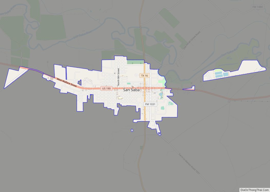
San Saba is a city located in, and the county seat of, San Saba County, Texas, United States. It was settled in 1854 and named for its location on the San Saba River. Its population was 3,099 at the 2010 census. San Saba city overview: Name: San Saba city LSAD Code: 25 LSAD Description: city ... Read more
Map of San Saba city
Map of San Perlita city
San Perlita (Santa Perlita) is a city in Willacy County, Texas, United States. The population was 573 at the 2010 census. It may be included as part of the Brownsville–Harlingen–Raymondville and the Matamoros–Brownsville metropolitan areas. San Perlita city overview: Name: San Perlita city LSAD Code: 25 LSAD Description: city (suffix) State: Texas County: Willacy County ... Read more
Map of San Perlita city
Map of Sanger city, Texas
Sanger is a city in Denton County, Texas, United States. The population was 6,916 at the 2010 census, and 8,839 at the 2020 census. Sanger city overview: Name: Sanger city LSAD Code: 25 LSAD Description: city (suffix) State: Texas County: Denton County Elevation: 673 ft (205 m) Total Area: 11.81 sq mi (30.59 km²) Land Area: 11.76 sq mi (30.46 km²) Water Area: ... Read more
Map of Sanger city, Texas
Map of Sanford town, Texas
Sanford is a town in Hutchinson County, Texas, United States. The population was 164 at the 2010 census, down from 203 at the 2000 census. On December 28, 1974, Hee Haw Season 6, Episode 16, Red Steagall saluted his hometown of Sanford, population 181. Sanford town overview: Name: Sanford town LSAD Code: 43 LSAD Description: ... Read more
Map of Sanford town, Texas
Map of Sandy Point city
Sandy Point is a city on Farm to Market Road 521 (FM 521) in north central Brazoria County, Texas, United States. The small community is located near a state prison. In the 19th century, the settlement served nearby sugar cane and cotton plantations. Sandy Point’s post office, school and railroad have disappeared, but there were two ... Read more
Map of Sandy Point city
Map of Santa Monica CDP, Texas
Santa Monica is a census-designated place (CDP) in Willacy County, Texas, United States. The population was 83 at the 2010 census. Santa Monica CDP overview: Name: Santa Monica CDP LSAD Code: 57 LSAD Description: CDP (suffix) State: Texas County: Willacy County Elevation: 16 ft (5 m) Total Area: 1.0 sq mi (3 km²) Land Area: 1.0 sq mi (3 km²) Water Area: 0.0 sq mi ... Read more
Map of Santa Monica CDP, Texas
Map of Santa Maria CDP, Texas
Santa Maria is a census-designated place (CDP) in Cameron County, Texas, United States. The population was 733 at the 2010 census, down from 846 at the 2000 census. It is part of the Brownsville–Harlingen Metropolitan Statistical Area. Santa Maria CDP overview: Name: Santa Maria CDP LSAD Code: 57 LSAD Description: CDP (suffix) State: Texas County: ... Read more
Map of Santa Maria CDP, Texas
Map of Santa Fe city, Texas
Santa Fe (English: Holy Faith) is a city in Galveston County, Texas, United States. It is named for the Santa Fe Railroad (now part of BNSF Railway) which runs through the town alongside State Highway 6. The population of Santa Fe at the 2010 census was 12,222. Santa Fe city overview: Name: Santa Fe city ... Read more
Map of Santa Fe city, Texas
Map of Santa Cruz CDP, Texas
Santa Cruz is a census-designated place (CDP) in Starr County, Texas, United States. It is a new CDP for 2010 census with a population of 54. There is a former CDP of the same name that was split into the El Chaparral and Santa Rosa CDPs. Santa Cruz CDP overview: Name: Santa Cruz CDP LSAD ... Read more
Map of Santa Cruz CDP, Texas
Map of Santa Clara city, Texas
Santa Clara is a city in Guadalupe County, Texas, United States. The population was 725 at the 2010 census, down from 889 at the 2000 census. It is part of the San Antonio Metropolitan Statistical Area. Santa Clara was incorporated as a city in May 1999. Santa Clara city overview: Name: Santa Clara city LSAD ... Read more
Map of Santa Clara city, Texas
Map of Santa Anna CDP
Santa Anna is a census-designated place (CDP) in Starr County, Texas, United States. This was a new CDP for the 2010 census with a population of 13. Santa Anna CDP overview: Name: Santa Anna CDP LSAD Code: 57 LSAD Description: CDP (suffix) State: Texas County: Starr County Total Area: 0.7 sq mi (2 km²) Land Area: 0.7 sq mi (2 km²) ... Read more
Map of Santa Anna CDP
Map of Sansom Park city
Sansom Park is a city in Tarrant County, Texas, United States. Its population was 4,686 at the 2010 census. Sansom Park city overview: Name: Sansom Park city LSAD Code: 25 LSAD Description: city (suffix) State: Texas County: Tarrant County Elevation: 751 ft (229 m) Total Area: 1.24 sq mi (3.21 km²) Land Area: 1.24 sq mi (3.21 km²) Water Area: 0.00 sq mi (0.00 km²) Total ... Read more
Map of Sansom Park city