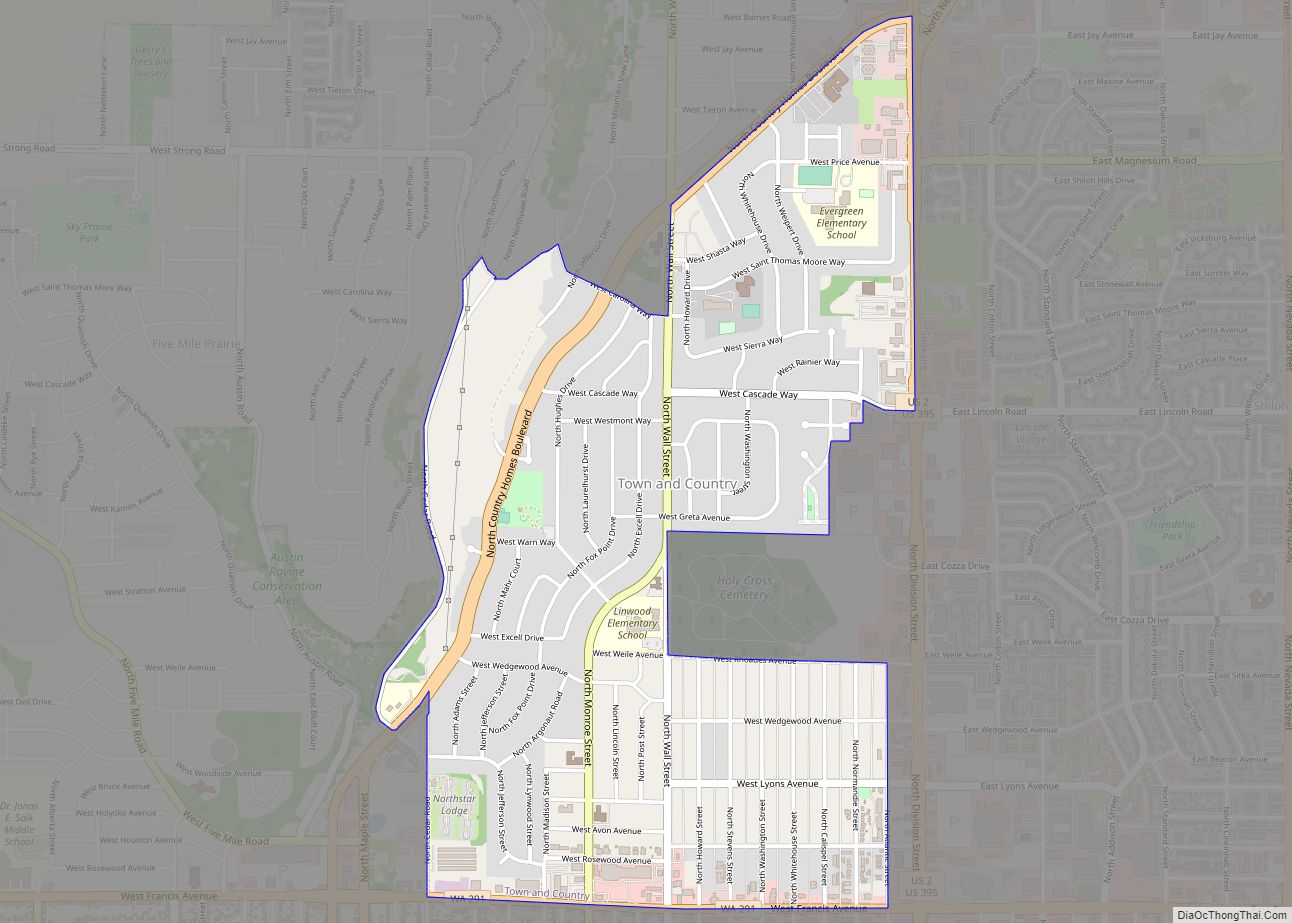
Town and Country (often referred to locally as ‘Lynwood’) is a census-designated place (CDP) in Spokane County, Washington, United States. The population was 5,068 at the 2020 census. Town and Country CDP overview: Name: Town and Country CDP LSAD Code: 57 LSAD Description: CDP (suffix) State: Washington County: Spokane County Elevation: 2,060 ft (628 m) Total Area: ... Read more
Map of US Cities and Places
Taholah is a census-designated place (CDP) on the Quinault Indian Reservation, in Grays Harbor County, Washington, United States. Named for a Quinault chief in 1905, its population was 840 at the 2010 census. The headquarters for the Quinault Indian Nation was moved to Taholah from the town of Quinault on the shore of Lake Quinault. ... Read more
Swede Heaven is a census-designated place (CDP) in Snohomish County, Washington, United States. The population was 768 at the 2010 census. Swede Heaven CDP overview: Name: Swede Heaven CDP LSAD Code: 57 LSAD Description: CDP (suffix) State: Washington County: Snohomish County Elevation: 413 ft (126 m) Total Area: 7.014 sq mi (18.17 km²) Land Area: 7.007 sq mi (18.15 km²) Water Area: 0.007 sq mi ... Read more
Valley is a census-designated place and unincorporated community in Stevens County, Washington, United States. In the 2010 census the population was 146. The town of Valley was named by Daniel C. Corbin. Mr. Corbin named the town Valley, because it is at the entrance to the Colville Valley. The Spokane Falls and Northern Railway was ... Read more
Vader is a city in Lewis County, Washington, United States. The population was 629 at the 2020 census. Vader city overview: Name: Vader city LSAD Code: 25 LSAD Description: city (suffix) State: Washington County: Lewis County Elevation: 161 ft (49 m) Total Area: 0.93 sq mi (2.41 km²) Land Area: 0.93 sq mi (2.41 km²) Water Area: 0.00 sq mi (0.00 km²) Total Population: 629 Population ... Read more
Upper Elochoman is a census-designated place (CDP) in Wahkiakum County, Washington, United States. The population was 193 at the 2010 census. The CDP includes the State Camp community. Upper Elochoman CDP overview: Name: Upper Elochoman CDP LSAD Code: 57 LSAD Description: CDP (suffix) State: Washington County: Wahkiakum County Elevation: 102 ft (31 m) Total Area: 193 Area ... Read more
University Place is a city in Pierce County, Washington, United States. Its population was 34,866 at the 2020 census. Based on per capita income, University Place ranks 81st of 522 areas in the state of Washington to be ranked. University Place city overview: Name: University Place city LSAD Code: 25 LSAD Description: city (suffix) State: ... Read more
Uniontown town overview: Name: Uniontown town LSAD Code: 43 LSAD Description: town (suffix) State: Washington County: Whitman County FIPS code: 5373360 Online Interactive Map Uniontown online map. Source: Basemap layers from Google Map, Open Street Map (OSM), Arcgisonline, Wmflabs. Boundary Data from Database of Global Administrative Areas. Uniontown location map. Where is Uniontown town? Uniontown ... Read more
Union or Union City is a small census-designated place in Mason County, Washington, United States. The community lies along the southern shore of the Great Bend of the Hood Canal, near the mouth of the Skokomish River, which flows from the nearby Olympic Mountains. The U.S. Census reported a population of 631 inhabitants in the ... Read more
Union Hill-Novelty Hill is a census-designated place (CDP) in King County, Washington, United States. The area was first recognized by the Census Bureau in the 2000 census. The population was 18,805 at the 2010 census. Based on per capita income, Union Hill-Novelty Hill ranks 5th of 522 areas in the state of Washington to be ... Read more
Union Gap is a city in Yakima County, Washington, United States. As of the 2020 census, the city population was 6,568. Union Gap has become the retail hub for the entire Yakima Valley as a result of Valley Mall and other thriving businesses being located here. Part of the city is part of the Yakama ... Read more
Twisp town overview: Name: Twisp town LSAD Code: 43 LSAD Description: town (suffix) State: Washington County: Okanogan County FIPS code: 5373080 Online Interactive Map Twisp online map. Source: Basemap layers from Google Map, Open Street Map (OSM), Arcgisonline, Wmflabs. Boundary Data from Database of Global Administrative Areas. Twisp location map. Where is Twisp town? Twisp ... Read more