Map of Arapahoe CDP, Wyoming
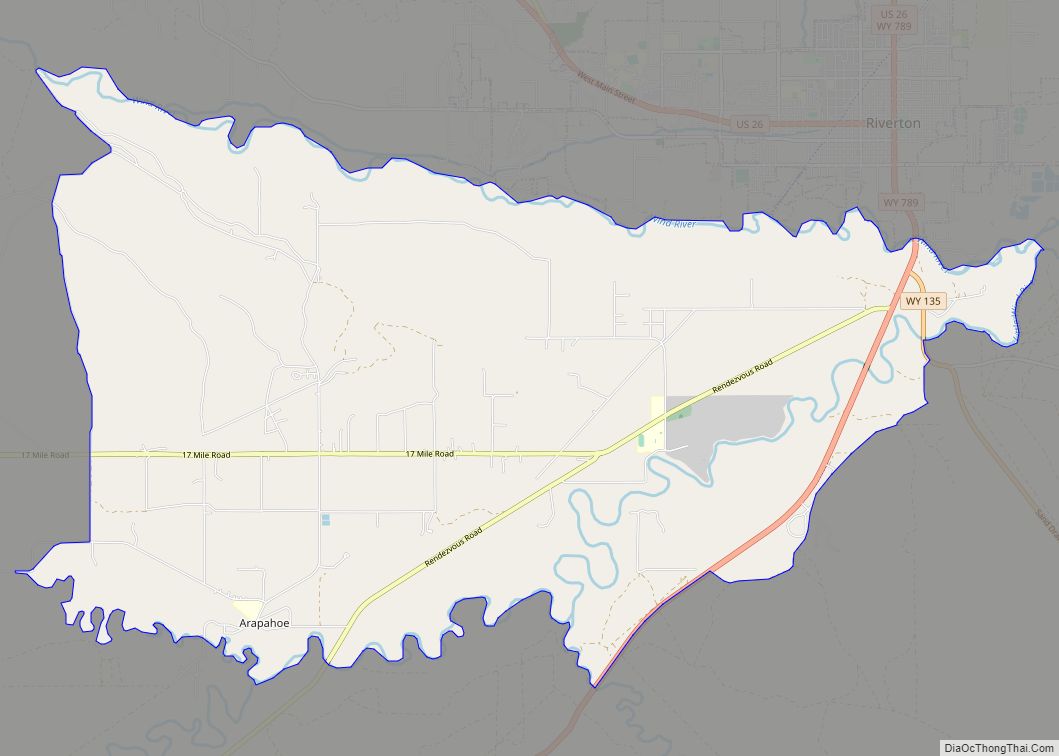
Arapahoe (Arapaho: Hinono’ei’) is a census-designated place (CDP) in Fremont County, Wyoming, United States. The population was 1,656 at the 2010 census. A Catholic mission was founded here in 1884. St Stephen’s Mission Church, located near Arapahoe, is part of the Catholic mission. Arapahoe CDP overview: Name: Arapahoe CDP LSAD Code: 57 LSAD Description: CDP ... Read more
Map of Arapahoe CDP, Wyoming
Map of Worthington town, West Virginia
Worthington is a town in Marion County, West Virginia, United States. The population was 158 at the 2010 census. Worthington was incorporated in 1893 and named for Colonel George Worthington, an early settler. U.S. Route 19 passes through the town. Worthington town overview: Name: Worthington town LSAD Code: 43 LSAD Description: town (suffix) State: West ... Read more
Map of Worthington town, West Virginia
Map of Womelsdorf (Coalton) town
Womelsdorf (Coalton) is a town in Randolph County, West Virginia, United States. The population was 190 at the 2020 census. Womelsdorf was the name of a mining official; the variant name of Coalton was given on account of local mining operations. Womelsdorf (Coalton) town overview: Name: Womelsdorf (Coalton) town LSAD Code: 43 LSAD Description: town ... Read more
Map of Womelsdorf (Coalton) town
Map of Wolf Summit CDP
Wolf Summit is a census-designated place and coal town in Harrison County, West Virginia, United States. Its population was 272 as of the 2010 census. The community was named after the surname Wolf and its being the highest point on the railroad between Grafton and Parkersburg. Wolf Summit CDP overview: Name: Wolf Summit CDP LSAD ... Read more
Map of Wolf Summit CDP
Map of Winfield town, West Virginia
Winfield is a city in and the county seat of Putnam County, West Virginia, United States, located along the Kanawha River. The population was 2,397 at the 2020 census. It is part of the Huntington–Ashland metropolitan area. Winfield town overview: Name: Winfield town LSAD Code: 43 LSAD Description: town (suffix) State: West Virginia County: Putnam ... Read more
Map of Winfield town, West Virginia
Map of Albin town
Albin is a town in Laramie County, Wyoming, United States. It is part of the Cheyenne Metropolitan Statistical Area. The population was 181 at the 2010 census. Albin town overview: Name: Albin town LSAD Code: 43 LSAD Description: town (suffix) State: Wyoming County: Laramie County Elevation: 5,338 ft (1,627 m) Total Area: 0.15 sq mi (0.38 km²) Land Area: 0.15 sq mi ... Read more
Map of Albin town
Map of Afton town, Wyoming
Afton is a town in Lincoln County, Wyoming, United States. The population was 1,911 at the 2010 census. Afton is home to the world’s largest arch made of elk antlers. Spanning 75 feet (23 m) across the four lanes of U.S. Highway 89, the arch consists of 3,011 elk antlers and weighs 15 tons. Afton town ... Read more
Map of Afton town, Wyoming
Map of Auburn CDP, Wyoming
Auburn is a census-designated place (CDP) in Lincoln County, Wyoming, United States. As of the 2010 census, the CDP population was 328. The first settlement at Auburn was made in 1879. Auburn CDP overview: Name: Auburn CDP LSAD Code: 57 LSAD Description: CDP (suffix) State: Wyoming County: Lincoln County Elevation: 6,053 ft (1,845 m) Total Area: 2.1 sq mi ... Read more
Map of Auburn CDP, Wyoming
Map of Bondurant CDP, Wyoming
Bondurant is a census-designated place (CDP) in Sublette County, Wyoming, United States. The population was 93 at the 2010 census. The town was named after B. F. Bondurant. Bondurant CDP overview: Name: Bondurant CDP LSAD Code: 57 LSAD Description: CDP (suffix) State: Wyoming County: Sublette County Elevation: 6,611 ft (2,015 m) Total Area: 52.8 sq mi (137 km²) Land Area: ... Read more
Map of Bondurant CDP, Wyoming
Map of Big Piney town
Big Piney is a town in Sublette County, Wyoming, United States. The population was 552 at the 2010 census. Big Piney town overview: Name: Big Piney town LSAD Code: 43 LSAD Description: town (suffix) State: Wyoming County: Sublette County Elevation: 6,824 ft (2,080 m) Total Area: 0.51 sq mi (1.32 km²) Land Area: 0.51 sq mi (1.32 km²) Water Area: 0.00 sq mi (0.00 km²) Total ... Read more
Map of Big Piney town
Map of Big Horn CDP
Big Horn is an unincorporated community and census-designated place (CDP) in Sheridan County, Wyoming, United States. The population was 198 at the 2000 census and 490 at the 2010 census. Big Horn CDP overview: Name: Big Horn CDP LSAD Code: 57 LSAD Description: CDP (suffix) State: Wyoming County: Sheridan County Elevation: 4,062 ft (1,238 m) Total Area: ... Read more
Map of Big Horn CDP
Map of Beulah CDP, Wyoming
Beulah is a census-designated place (CDP) in eastern Crook County, Wyoming, United States, along Sand Creek, a tributary of the Belle Fourche River. According to local residents, the population is 33. When the 2010 census reported the population as 73, the highway sign at the town entrance was changed. In 2012, Beulah residents succeeded in ... Read more
Map of Beulah CDP, Wyoming