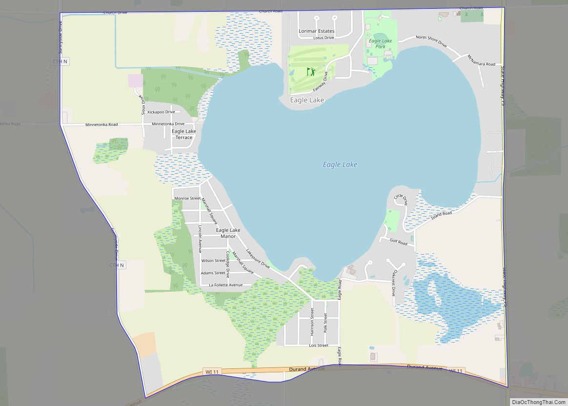
Map of Dodgeville city
Dodgeville is a city in and the county seat of Iowa County, Wisconsin, United States. The population was 4,984 at the 2020 census, making it the county’s most populous city. Dodgeville is part of the Madison Metropolitan Statistical Area. Dodgeville city overview: Name: Dodgeville city LSAD Code: 25 LSAD Description: city (suffix) State: Wisconsin County: ... Read more
Map of Dodgeville city
Map of Elmwood Park village, Wisconsin
Elmwood Park is a village in Racine County, Wisconsin, United States. The population was 510 at the 2020 census. Elmwood Park village overview: Name: Elmwood Park village LSAD Code: 47 LSAD Description: village (suffix) State: Wisconsin County: Racine County Elevation: 646 ft (197 m) Total Area: 0.15 sq mi (0.40 km²) Land Area: 0.15 sq mi (0.39 km²) Water Area: 0.00 sq mi (0.01 km²) Total ... Read more
Map of Elmwood Park village, Wisconsin
Map of Elm Grove village, Wisconsin
Elm Grove is a village in Waukesha County, Wisconsin, United States. The population was 6,524 at the 2020 census. Elm Grove was named as America’s best suburb by Business Insider in October 2014. Elm Grove village overview: Name: Elm Grove village LSAD Code: 47 LSAD Description: village (suffix) State: Wisconsin County: Waukesha County Elevation: 748 ft ... Read more
Map of Elm Grove village, Wisconsin
Map of Ellsworth village, Wisconsin
Ellsworth is a village in and the county seat of Pierce County, Wisconsin, United States. The population was 3,348 at the 2020 census. The village is adjacent to the Town of Ellsworth and now incorporates the formerly separate district known as East Ellsworth. The municipality of Ellsworth and its surroundings are slowly becoming incorporated into ... Read more
Map of Ellsworth village, Wisconsin
Map of Ellison Bay CDP
Ellison Bay is an unincorporated community and census-designated place in northern Door County, Wisconsin, United States, within the town of Liberty Grove and is located on Highway 42 along the Green Bay. As of the 2020 census, its population is 249. Sur La Baie, one of Wisconsin’s largest and most expensive homes, is located nearby. ... Read more
Map of Ellison Bay CDP
Map of Elkhart Lake village
Elkhart Lake is a village in Sheboygan County, Wisconsin, United States, located within the northwestern part of the county within the Town of Rhine. The population was 967 at the 2010 census. It is included in the Sheboygan, Wisconsin Metropolitan Statistical Area. Elkhart Lake may be best known for hosting road races on public county ... Read more
Map of Elkhart Lake village
Map of Eleva village
Eleva is a village in Trempealeau County, Wisconsin, along the Buffalo River. The population was 670 at the 2010 Census and reached 685 in the 2020 Census. Eleva village overview: Name: Eleva village LSAD Code: 47 LSAD Description: village (suffix) State: Wisconsin County: Trempealeau County Elevation: 863 ft (263 m) Total Area: 0.58 sq mi (1.50 km²) Land Area: 0.56 sq mi ... Read more
Map of Eleva village
Map of Elderon village
Elderon is a town in Marathon County, Wisconsin, United States. It is part of the Wausau, Wisconsin Metropolitan Statistical Area. The population was 606 at the 2010 census. The unincorporated community of Ingersoll is located in the town. Elderon village overview: Name: Elderon village LSAD Code: 47 LSAD Description: village (suffix) State: Wisconsin County: Marathon ... Read more
Map of Elderon village
Map of Eland village
Eland (formerly Eland Junction) is a village in Shawano County, Wisconsin, in the United States. The population was 202 at the 2010 census. Eland village overview: Name: Eland village LSAD Code: 47 LSAD Description: village (suffix) State: Wisconsin County: Shawano County Elevation: 1,234 ft (376 m) Total Area: 2.21 sq mi (5.71 km²) Land Area: 2.21 sq mi (5.71 km²) Water Area: 0.00 sq mi ... Read more
Map of Eland village
Map of Endeavor village
Endeavor is a village in Marquette County, Wisconsin, United States. The population was 468 at the 2010 census. Endeavor village overview: Name: Endeavor village LSAD Code: 47 LSAD Description: village (suffix) State: Wisconsin County: Marquette County Elevation: 791 ft (241 m) Total Area: 0.70 sq mi (1.80 km²) Land Area: 0.64 sq mi (1.65 km²) Water Area: 0.06 sq mi (0.15 km²) Total Population: 468 Population ... Read more
Map of Endeavor village
Map of Emerald CDP
Emerald is a census-designated place in St. Croix County, Wisconsin, United States. Emerald is located in the towns of Emerald and Glenwood, 4.5 miles (7.2 km) west-northwest of Glenwood City. As of the 2010 census, its population was 161. Emerald CDP overview: Name: Emerald CDP LSAD Code: 57 LSAD Description: CDP (suffix) State: Wisconsin County: St. ... Read more
Map of Emerald CDP
Map of Edmund CDP
Edmund is a census-designated place (CDP) in the Town of Linden in Iowa County, Wisconsin, United States. Edmund CDP overview: Name: Edmund CDP LSAD Code: 57 LSAD Description: CDP (suffix) State: Wisconsin County: Iowa County Elevation: 1,204 ft (367 m) Total Area: 0.342 sq mi (0.89 km²) Land Area: 0.342 sq mi (0.89 km²) Water Area: 0 sq mi (0 km²) Total Population: 173 Population Density: ... Read more
Map of Edmund CDP