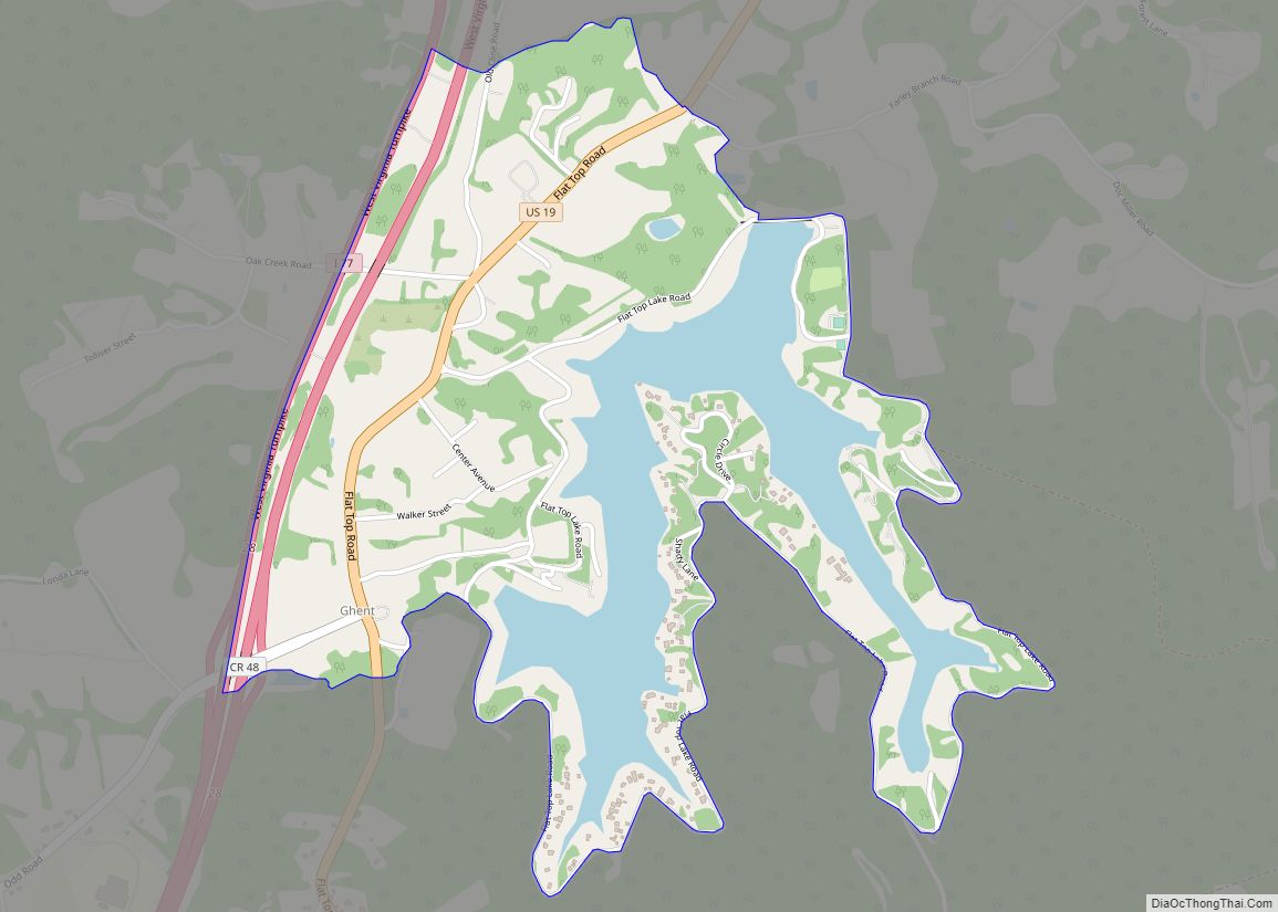
Map of Lovell town

Map of Lovell town

Lovell is the largest town in Big Horn County, Wyoming, United States. The population was 2,360 at the 2010 census. Lovell town overview: Name: Lovell town LSAD Code: 43 LSAD Description: town (suffix) State: Wyoming County: Big Horn County Elevation: 3,832 ft (1,168 m) Total Area: 1.10 sq mi (2.85 km²) Land Area: 1.10 sq mi (2.85 km²) Water Area: 0.00 sq mi (0.00 km²) Total … Read more

Map of Lost Springs town, Wyoming

Map of Lost Springs town, Wyoming

Lost Springs is a town in Converse County, Wyoming, United States. As of the 2020 census, the population was 6. Lost Springs town overview: Name: Lost Springs town LSAD Code: 43 LSAD Description: town (suffix) State: Wyoming County: Converse County Elevation: 4,997 ft (1,523 m) Total Area: 0.09 sq mi (0.23 km²) Land Area: 0.09 sq mi (0.23 km²) Water Area: 0.00 sq mi (0.00 km²) … Read more

Map of Lonetree CDP

Map of Lonetree CDP

Lonetree is a census-designated place (CDP) in Uinta County, Wyoming, United States. The population was 49 at the 2010 census. Lonetree CDP overview: Name: Lonetree CDP LSAD Code: 57 LSAD Description: CDP (suffix) State: Wyoming County: Uinta County Elevation: 7,556 ft (2,303 m) Total Area: 45.6 sq mi (118.2 km²) Land Area: 45.6 sq mi (118.1 km²) Water Area: 0.0 sq mi (0.1 km²) Total Population: … Read more

Map of Little America CDP

Map of Little America CDP

Little America is a census-designated place (CDP) in Sweetwater County, Wyoming, United States. The population was 68 at the 2010 census. The community got its name from the Little America motel, which was purposefully located in a remote location as a haven, not unlike the Little America base camp the polar explorer Richard E. Byrd … Read more

Map of Lingle town

Map of Lingle town

Lingle is a town in Goshen County, Wyoming, United States. The population was 468 at the 2010 census. Former Wyoming Supreme Court Justice Richard V. Thomas was reared in Lingle. Lingle town overview: Name: Lingle town LSAD Code: 43 LSAD Description: town (suffix) State: Wyoming County: Goshen County Elevation: 4,173 ft (1,272 m) Total Area: 0.31 sq mi (0.81 km²) … Read more

Map of Meeteetse town

Map of Meeteetse town

Meeteetse is a town in Park County, Wyoming, United States. The population was 327 at the 2010 census. Meeteetse town overview: Name: Meeteetse town LSAD Code: 43 LSAD Description: town (suffix) State: Wyoming County: Park County Elevation: 5,751 ft (1,753 m) Total Area: 0.87 sq mi (2.26 km²) Land Area: 0.87 sq mi (2.26 km²) Water Area: 0.00 sq mi (0.00 km²) Total Population: 327 Population … Read more

Map of Medicine Bow town

Map of Medicine Bow town

Medicine Bow is a town in Carbon County, Wyoming, United States. Its population was 284 at the 2010 census. Medicine Bow town overview: Name: Medicine Bow town LSAD Code: 43 LSAD Description: town (suffix) State: Wyoming County: Carbon County Elevation: 6,565 ft (2,001 m) Total Area: 3.46 sq mi (8.96 km²) Land Area: 3.46 sq mi (8.96 km²) Water Area: 0.00 sq mi (0.00 km²) Total … Read more

Map of Meadow Acres CDP

Map of Meadow Acres CDP

Meadow Acres is a census-designated place (CDP) in Natrona County, Wyoming, United States. It is part of the Casper, Wyoming Metropolitan Statistical Area. The population was 198 at the 2010 census. Meadow Acres CDP overview: Name: Meadow Acres CDP LSAD Code: 57 LSAD Description: CDP (suffix) State: Wyoming County: Natrona County Elevation: 5,046 ft (1,538 m) Total … Read more

Map of Osmond CDP, Wyoming

Map of Osmond CDP, Wyoming

Osmond is a census-designated place (CDP) in Lincoln County, Wyoming, United States. The population was 397 at the 2010 census. Osmond CDP overview: Name: Osmond CDP LSAD Code: 57 LSAD Description: CDP (suffix) State: Wyoming County: Lincoln County Elevation: 6,329 ft (1,929 m) Total Area: 3.2 sq mi (8.4 km²) Land Area: 3.2 sq mi (8.4 km²) Water Area: 0.0 sq mi (0.0 km²) Total Population: … Read more

Map of McKinnon CDP

Map of McKinnon CDP

McKinnon is a census-designated place (CDP) in Sweetwater County, Wyoming, United States. The population was 60 at the 2010 census. The first rendezvous of white traders and trappers in the Rocky Mountains took place in July 1825, just north of McKinnon along the Henrys Fork river. They joined members of William Henry Ashley’s expedition. McKinnon … Read more

Map of Osage CDP, Wyoming

Map of Osage CDP, Wyoming

Osage is a census-designated place (CDP) in Weston County, Wyoming, United States. The population was 151 at the 2020 census. Osage CDP overview: Name: Osage CDP LSAD Code: 57 LSAD Description: CDP (suffix) State: Wyoming County: Weston County Elevation: 4,321 ft (1,317 m) Total Area: 1.9 sq mi (5.0 km²) Land Area: 1.9 sq mi (5.0 km²) Water Area: 0.0 sq mi (0.0 km²) Total Population: … Read more

Map of Marbleton town

Map of Marbleton town

Marbleton is a town in Sublette County, Wyoming, United States. The population was 1,094 at the 2010 census. Marbleton town overview: Name: Marbleton town LSAD Code: 43 LSAD Description: town (suffix) State: Wyoming County: Sublette County Elevation: 6,867 ft (2,093 m) Total Area: 0.91 sq mi (2.35 km²) Land Area: 0.91 sq mi (2.35 km²) Water Area: 0.00 sq mi (0.00 km²) Total Population: 1,094 Population … Read more