Map of Etna CDP, Wyoming
Etna is a census-designated place (CDP) in Lincoln County, Wyoming, United States. The population was 164 at the 2010 census. Etna CDP overview: Name: Etna CDP LSAD Code: 57 LSAD Description: CDP (suffix) State: Wyoming County: Lincoln County Elevation: 5,827 ft (1,776 m) Total Area: 2.0 sq mi (5.1 km²) Land Area: 2.0 sq mi (5.1 km²) Water Area: 0.0 sq mi (0.0 km²) Total Population: ... Read more
Map of Etna CDP, Wyoming
Map of Esterbrook CDP
Esterbrook is a village, and the locus of a same-named census-designated place (CDP), in Converse County, Wyoming, United States in the Medicine Bow National Forest. The population was 52 at the 2010 census. Esterbrook CDP overview: Name: Esterbrook CDP LSAD Code: 57 LSAD Description: CDP (suffix) State: Wyoming County: Converse County Elevation: 6,516 ft (1,986 m) Total ... Read more
Map of Esterbrook CDP
Map of Garland CDP, Wyoming
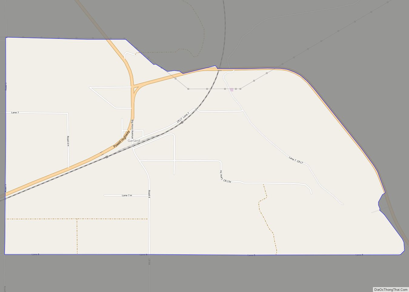
Garland is a census-designated place in Park County, Wyoming, United States. The population was 115 at the 2010 census. Garland CDP overview: Name: Garland CDP LSAD Code: 57 LSAD Description: CDP (suffix) State: Wyoming County: Park County Elevation: 4,255 ft (1,297 m) Total Area: 3.4 sq mi (9 km²) Land Area: 3.4 sq mi (9 km²) Water Area: 0.0 sq mi (0 km²) Total Population: 115 ... Read more
Map of Garland CDP, Wyoming
Map of Glenrock town
Glenrock is a town in Converse County, Wyoming, United States. The population was 2,576 at the 2010 census. Glenrock town overview: Name: Glenrock town LSAD Code: 43 LSAD Description: town (suffix) State: Wyoming County: Converse County Elevation: 5,020 ft (1,530 m) Total Area: 2.30 sq mi (5.96 km²) Land Area: 2.30 sq mi (5.96 km²) Water Area: 0.00 sq mi (0.00 km²) Total Population: 2,576 Population ... Read more
Map of Glenrock town
Map of Kelly CDP, Wyoming
Kelly is a census-designated place (CDP) in Teton County in the U.S. state of Wyoming. The population was 138 at the 2010 census. Kelly CDP overview: Name: Kelly CDP LSAD Code: 57 LSAD Description: CDP (suffix) State: Wyoming County: Teton County Elevation: 6,653 ft (2,028 m) Total Area: 0.48 sq mi (1.24 km²) Land Area: 0.48 sq mi (1.24 km²) Water Area: 0.0 sq mi ... Read more
Map of Kelly CDP, Wyoming
Map of Jeffrey City CDP
Jeffrey City is a former uranium mining boomtown located in Fremont County, in the central part of the U.S. state of Wyoming. The town is known in Wyoming and the American West as symbol of a boomtown that went “bust” very quickly, as the mine was shut down in 1982 and over 95% of the ... Read more
Map of Jeffrey City CDP
Map of Lost Springs town, Wyoming
Lost Springs is a town in Converse County, Wyoming, United States. As of the 2020 census, the population was 6. Lost Springs town overview: Name: Lost Springs town LSAD Code: 43 LSAD Description: town (suffix) State: Wyoming County: Converse County Elevation: 4,997 ft (1,523 m) Total Area: 0.09 sq mi (0.23 km²) Land Area: 0.09 sq mi (0.23 km²) Water Area: 0.00 sq mi (0.00 km²) ... Read more
Map of Lost Springs town, Wyoming
Map of Osage CDP, Wyoming
Osage is a census-designated place (CDP) in Weston County, Wyoming, United States. The population was 151 at the 2020 census. Osage CDP overview: Name: Osage CDP LSAD Code: 57 LSAD Description: CDP (suffix) State: Wyoming County: Weston County Elevation: 4,321 ft (1,317 m) Total Area: 1.9 sq mi (5.0 km²) Land Area: 1.9 sq mi (5.0 km²) Water Area: 0.0 sq mi (0.0 km²) Total Population: ... Read more
Map of Osage CDP, Wyoming
Map of Orin CDP
Orin is a hamlet and the locus of a same-named census-designated place (CDP) in Converse County, Wyoming, United States. The population was 46 at the 2010 census. Orin CDP overview: Name: Orin CDP LSAD Code: 57 LSAD Description: CDP (suffix) State: Wyoming County: Converse County Elevation: 4,705 ft (1,434 m) Total Area: 1.1 sq mi (2.9 km²) Land Area: 1.0 sq mi ... Read more
Map of Orin CDP
Map of Mills town
Mills is a town in Natrona County, Wyoming, United States. It is part of the Casper, Wyoming Metropolitan Statistical Area. The population was 3,461 at the 2010 census. Mills town overview: Name: Mills town LSAD Code: 43 LSAD Description: town (suffix) State: Wyoming County: Natrona County Elevation: 5,125 ft (1,562 m) Total Area: 2.99 sq mi (7.74 km²) Land Area: ... Read more
Map of Mills town
Map of Ralston CDP, Wyoming
Ralston is a census-designated place (CDP) in Park County, Wyoming, United States. The population was 280 at the 2010 census. Ralston CDP overview: Name: Ralston CDP LSAD Code: 57 LSAD Description: CDP (suffix) State: Wyoming County: Park County Elevation: 4,554 ft (1,388 m) Total Area: 5.6 sq mi (14.6 km²) Land Area: 5.6 sq mi (14.6 km²) Water Area: 0.0 sq mi (0.0 km²) Total Population: ... Read more
Map of Ralston CDP, Wyoming
Map of Purple Sage CDP
Purple Sage is a census-designated place (CDP) in Sweetwater County, Wyoming, United States. The population was 535 at the 2010 census. Purple Sage CDP overview: Name: Purple Sage CDP LSAD Code: 57 LSAD Description: CDP (suffix) State: Wyoming County: Sweetwater County Elevation: 6,227 ft (1,898 m) Total Area: 0.33 sq mi (0.9 km²) Land Area: 0.33 sq mi (0.9 km²) Water Area: 0.0 sq mi ... Read more
Map of Purple Sage CDP