Map of Stratton town, Colorado
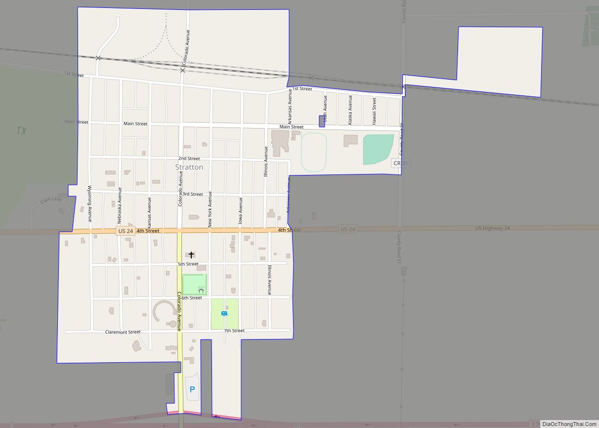
Stratton is a statutory town in Kit Carson County, Colorado, United States. The population was 656 at the 2020 census. Stratton was named in honor of the gold miner and philanthropist Winfield Scott Stratton. Stratton town overview: Name: Stratton town LSAD Code: 43 LSAD Description: town (suffix) State: Colorado County: Kit Carson County Incorporated: April ... Read more
Map of Stratton town, Colorado
Map of Stratmoor CDP
Stratmoor (commonly known as Stratmoor Hills) is an unincorporated community and a census-designated place (CDP) located in and governed by El Paso County, Colorado, United States. The CDP is a part of the Colorado Springs, CO Metropolitan Statistical Area. The population of the Stratmoor CDP was 6,518 at the United States Census 2020. The Colorado ... Read more
Map of Stratmoor CDP
Map of Superior town, Colorado
Superior is a statutory town in Boulder County, Colorado, United States, with a small, uninhabited segment of land area extending into Jefferson County. According to the 2020 census, the population of the city was 13,094. Superior town overview: Name: Superior town LSAD Code: 43 LSAD Description: town (suffix) State: Colorado County: Boulder County, Jefferson County ... Read more
Map of Superior town, Colorado
Map of Sunshine CDP, Colorado
Sunshine (also known as Sunshine Canyon) is an unincorporated community and a census-designated place (CDP) located in and governed by Boulder County, Colorado, United States. The CDP is a part of the Boulder, CO Metropolitan Statistical Area. The population of the Sunshine CDP was 198 at the United States Census 2020. The Boulder post office ... Read more
Map of Sunshine CDP, Colorado
Map of Sugarloaf CDP
Sugarloaf (also spelled Sugar Loaf) is an unincorporated community and a census-designated place (CDP) located in and governed by Boulder County, Colorado, United States. The CDP is a part of the Boulder, CO Metropolitan Statistical Area. The population of the Sugarloaf CDP was 274 at the United States Census 2020. The Boulder post office (Zip ... Read more
Map of Sugarloaf CDP
Map of Tall Timber CDP
Tall Timber is an unincorporated community and a census-designated place (CDP) located in and governed by Boulder County, Colorado, United States. The CDP is a part of the Boulder, CO Metropolitan Statistical Area. The population of the Tall Timber CDP was 185 at the United States Census 2020. The Boulder post office (Zip Code 80302) ... Read more
Map of Tall Timber CDP
Map of Tabernash CDP
Tabernash is an unincorporated town, a post office, and a census-designated place (CDP) located in and governed by Grand County, Colorado, United States. The Tabernash post office has the ZIP Code 80478. At the United States Census 2020, the population of the Tabernash CDP was 401. Tabernash CDP overview: Name: Tabernash CDP LSAD Code: 57 ... Read more
Map of Tabernash CDP
Map of Swink town, Colorado
Swink is a Statutory Town in Otero County, Colorado, United States. The population was 604 at the 2020 census. A post office called Swink has been in operation since 1906. The community was named after George W. Swink, a Colorado politician. Swink town overview: Name: Swink town LSAD Code: 43 LSAD Description: town (suffix) State: ... Read more
Map of Swink town, Colorado
Map of Telluride town
Telluride is the county seat and most populous town of San Miguel County in the southwestern portion of the U.S. state of Colorado. The town is a former silver mining camp on the San Miguel River in the western San Juan Mountains. The first gold mining claim was made in the mountains above Telluride in ... Read more
Map of Telluride town
Map of Timnath town
The Town of Timnath is a Statutory Town located in Larimer County, Colorado, United States. Founded in 1882, Timnath is a small agricultural/farming community located southeast of Fort Collins, Colorado, approximately one-half mile east of the Harmony Road/Interstate 25 interchange, on a small bluff east of the Cache la Poudre River. The surrounding farmlands have ... Read more
Map of Timnath town
Map of The Pinery CDP
The Pinery is an unincorporated community and a census-designated place (CDP) located in and governed by Douglas County, Colorado, United States. The CDP is a part of the Denver–Aurora–Lakewood, CO Metropolitan Statistical Area. The population of The Pinery CDP was 11,311 at the United States Census 2020. Douglas County governs the unincorporated community. The Parker ... Read more
Map of The Pinery CDP
Map of Towner CDP, Colorado
Towner is a census-designated place (CDP) in and governed by Kiowa County, Colorado, United States. The population of the Towner CDP was 18 at the United States Census 2020. The Sheridan Lake post office (Zip Code 81071) serves Towner postal addresses. Towner CDP overview: Name: Towner CDP LSAD Code: 57 LSAD Description: CDP (suffix) State: ... Read more
Map of Towner CDP, Colorado