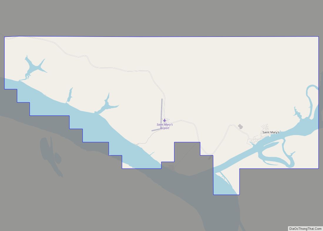
Map of St. George city

Map of St. George city, Alaska

St. George (Aleut: Anĝaaxchalux̂ or Sangiurgiix̂, Russian: Сент-Джордж) is a city in Aleutians West Census Area, Alaska, United States. At the 2010 census the population was 102, down from 152 in 2000. It is the main settlement of St. George Island in the Pribilofs, a small island group in the Bering Sea. St. George city … Read more

Map of South Van Horn CDP

Map of South Van Horn CDP

South Van Horn is a census-designated place (CDP) in the Fairbanks North Star Borough, Alaska, United States. At the 2010 census the population was 558, the 107th largest city or CDP in Alaska. It has a population density of 65.42 people per sq mi (25.26 per km). South Van Horn CDP overview: Name: South Van … Read more

Map of Stebbins city

Map of Stebbins city

Stebbins (Central Yupik: Tapraq, Inupiaq: Tapqaq; Atqa.wik) is a city in Nome Census Area, Alaska, United States. At the 2010 census the population was 556, up from 547 in 2000. Stebbins city overview: Name: Stebbins city LSAD Code: 25 LSAD Description: city (suffix) State: Alaska County: Nome Census Area Incorporated: July 15, 1969 Elevation: 16 ft … Read more

Map of St. Paul city

Map of St. Paul city, Alaska

St. Paul (Aleut: Tanax̂ Amix̂ or Sanpuulax̂, Russian: Сент-Пол, romanized: Sent-Pol) is a city in the Aleutians West Census Area, Alaska, United States. It is the main settlement of Saint Paul Island in the Pribilofs, a small island group in the Bering Sea. Saint Paul Island is well known as a birdwatching haven. The population was … Read more

Map of St. Michael city

Map of St. Michael city, Alaska

St. Michael (Central Yupik: Taciq, Inupiaq: Tasiq; Taziq, Russian: Сент-Майкл), historically referred to as Saint Michael, is a city in Nome Census Area, Alaska. The population was 401 at the 2010 census, up from 368 in 2000. St. Michael city overview: Name: St. Michael city LSAD Code: 25 LSAD Description: city (suffix) State: Alaska County: … Read more

Map of Stevens Village CDP

Map of Stevens Village CDP

Stevens Village (Denyeet in Koyukon) is a census-designated place (CDP) in Yukon-Koyukuk Census Area, Alaska, United States. The population was 78 at the 2010 census, down from 87 in 2000. The village is named for its first chief, Skidedlestalk “Old Steven” Stevens (1850-d. 1912~1920). Stevens Village CDP overview: Name: Stevens Village CDP LSAD Code: 57 … Read more

Map of Sterling CDP

Map of Sterling CDP, Alaska

Sterling is a census-designated place (CDP) in Kenai Peninsula Borough, Alaska, United States. At the 2020 census the population was 5,918, up from 5,617 in 2010. Sterling is the tenth-most populated CDP in Alaska. Sterling CDP overview: Name: Sterling CDP LSAD Code: 57 LSAD Description: CDP (suffix) State: Alaska County: Kenai Peninsula Borough Elevation: 220 ft … Read more

Map of Steele Creek CDP

Map of Steele Creek CDP

Steele Creek is a census-designated place (CDP) in Fairbanks North Star Borough, Alaska, United States. It is part of the Fairbanks, Alaska Metropolitan Statistical Area. As of the 2020 census, the population was 6,437, down from 6,662 in 2010. It is the eighth-most populated CDP in Alaska. Steele Creek CDP overview: Name: Steele Creek CDP … Read more

Map of Susitna North CDP

Map of Susitna North CDP

Susitna North is a census-designated place (CDP) in the Matanuska-Susitna Borough in the U.S. state of Alaska. It is part of the Anchorage, Alaska Metropolitan Statistical Area. The population was 1,564 at the 2020 census, up from 1,260 in 2010. The CDP was formerly named Y /ˈwaɪ/, for the intersection of the George Parks Highway … Read more

Map of Sunrise CDP

Map of Sunrise CDP, Alaska

Sunrise is a census-designated place (CDP) in Kenai Peninsula Borough, Alaska, United States. The population was 18 at the 2010 census, unchanged from 2000. Sunrise CDP overview: Name: Sunrise CDP LSAD Code: 57 LSAD Description: CDP (suffix) State: Alaska County: Kenai Peninsula Borough Elevation: 269 ft (82 m) Total Area: 13.02 sq mi (33.73 km²) Land Area: 13.02 sq mi (33.73 km²) Water … Read more

Map of Stony River CDP

Map of Stony River CDP

Stony River (Gidighuyghatno’ Xidochagg Qay’ in Deg Xinag, K’qizaghetnu Hdakaq’ in Dena’ina) is a census-designated place (CDP) in Bethel Census Area, Alaska, United States. The population was 54 at the 2010 census, down from 61 in 2000. Native inhabitants are mixed Athabaskan and Yup’ik ancestry of Alaska Native. Stony River village is the modern contact … Read more

Map of Takotna CDP

Map of Takotna CDP

Takotna(Tochotno’) IPA: [tʰot͡ʃʰoʔno] in Upper Kuskokwim) is a census-designated place (CDP) in the Yukon-Koyukuk Census Area, Alaska, United States. The population was 52 as of the 2010 Census, an increase of 4% from 50 at the 2000 Census. Takotna CDP overview: Name: Takotna CDP LSAD Code: 57 LSAD Description: CDP (suffix) State: Alaska County: Yukon-Koyukuk Census … Read more