Map of Ramos CDP, Texas
Ramos is a census-designated place (CDP) in Starr County, Texas, United States. It is a new CDP formed from part of the Roma Creek CDP prior to the 2010 census with a population of 116. Ramos CDP overview: Name: Ramos CDP LSAD Code: 57 LSAD Description: CDP (suffix) State: Texas County: Starr County Total Area: ... Read more
Map of Ramos CDP, Texas
Map of Ramirez-Perez CDP
Ramirez-Perez is a census-designated place (CDP) in Starr County, Texas, United States. It is a new CDP formed from part of the former La Casita-Garciasville CDP prior to the 2010 census with a population of 78. Ramirez-Perez CDP overview: Name: Ramirez-Perez CDP LSAD Code: 57 LSAD Description: CDP (suffix) State: Texas County: Starr County Total ... Read more
Map of Ramirez-Perez CDP
Map of Ramireno CDP
Ramireno is a census-designated place (CDP) in Zapata County, Texas, United States. This was a new CDP for the 2010 census with a population of 35. Ramireno CDP overview: Name: Ramireno CDP LSAD Code: 57 LSAD Description: CDP (suffix) State: Texas County: Zapata County Total Area: 1.5 sq mi (4 km²) Land Area: 1.5 sq mi (4 km²) Water Area: 0.0 sq mi ... Read more
Map of Ramireno CDP
Map of Ralls city
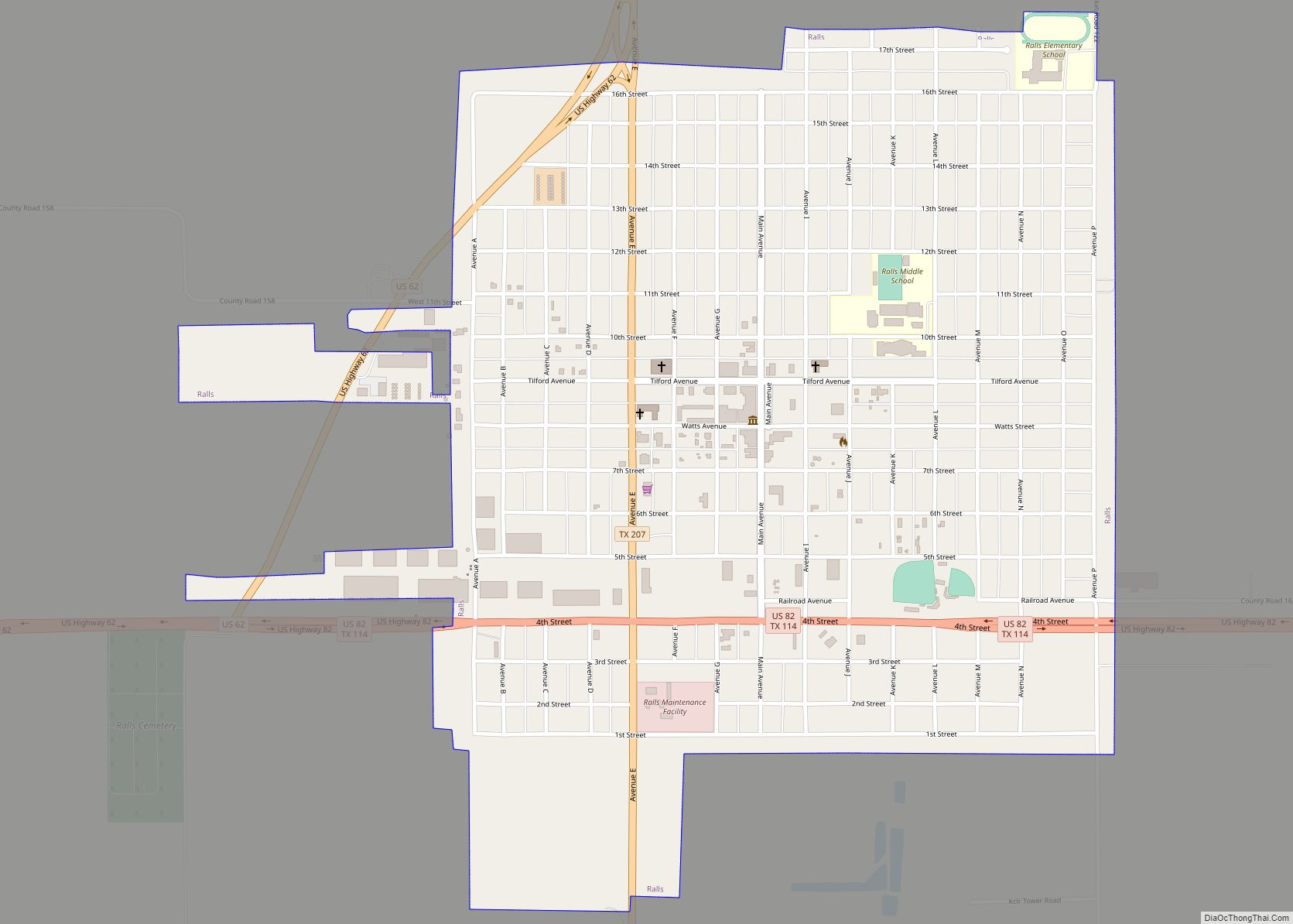
Ralls is a city in Crosby County, Texas, United States. It was named after John Robinson Ralls, who with the help of W.E. McLaughlin, laid out the townsite in July 1911. As of the 2010 census, it had a population of 1,944, down from 2,252 at the 2000 census. Ralls is surrounded by productive farm ... Read more
Map of Ralls city
Map of Rafael Pena CDP
Rafael Pena is a census-designated place (CDP) in Starr County, Texas, United States. This was a new CDP for the 2010 census with a population of 17. Rafael Pena CDP overview: Name: Rafael Pena CDP LSAD Code: 57 LSAD Description: CDP (suffix) State: Texas County: Starr County Total Area: 17 FIPS code: 4860290 Online Interactive ... Read more
Map of Rafael Pena CDP
Map of Radar Base CDP
Radar Base is a census-designated place (CDP) in Maverick County, Texas, United States. The population was 762 at the 2010 census. Radar Base CDP overview: Name: Radar Base CDP LSAD Code: 57 LSAD Description: CDP (suffix) State: Texas County: Maverick County Elevation: 860 ft (260 m) Total Area: 4.2 sq mi (10.9 km²) Land Area: 4.2 sq mi (10.9 km²) Water Area: 0.0 sq mi ... Read more
Map of Radar Base CDP
Map of Rancho Viejo CDP
Rancho Viejo is a census-designated place (CDP) in Starr County, Texas, United States. It is a new CDP formed from part of the La Rosita CDP prior to the 2010 census with a population of 228. Rancho Viejo CDP overview: Name: Rancho Viejo CDP LSAD Code: 57 LSAD Description: CDP (suffix) State: Texas County: Starr ... Read more
Map of Rancho Viejo CDP
Map of Rancho Chico CDP
Rancho Chico is a census-designated place (CDP) in San Patricio County, Texas, United States. The population was 396 at the 2010 census. Rancho Chico CDP overview: Name: Rancho Chico CDP LSAD Code: 57 LSAD Description: CDP (suffix) State: Texas County: San Patricio County Elevation: 49 ft (15 m) Total Area: 0.5 sq mi (1.3 km²) Land Area: 0.5 sq mi (1.3 km²) Water ... Read more
Map of Rancho Chico CDP
Map of Rancho Banquete CDP
Rancho Banquete is a census-designated place (CDP) in Nueces County, Texas, United States. The population was 424 at the 2010 census, down from 469 at the 2000 census. Rancho Banquete CDP overview: Name: Rancho Banquete CDP LSAD Code: 57 LSAD Description: CDP (suffix) State: Texas County: Nueces County Elevation: 92 ft (28 m) Total Area: 2.9 sq mi (7.4 km²) ... Read more
Map of Rancho Banquete CDP
Map of Rancho Alegre CDP
Rancho Alegre is an unincorporated area and census-designated place (CDP) in Jim Wells County, Texas, United States. The population was 1,704 at the 2010 census. Rancho Alegre CDP overview: Name: Rancho Alegre CDP LSAD Code: 57 LSAD Description: CDP (suffix) State: Texas County: Jim Wells County Elevation: 213 ft (65 m) Total Area: 1.28 sq mi (3.31 km²) Land Area: ... Read more
Map of Rancho Alegre CDP
Map of Ransom Canyon town
Ransom Canyon is a town in Lubbock County of West Texas, United States. The population was 1,096 at the 2010 census. It is part of the Lubbock Metropolitan Statistical Area. Ransom Canyon town overview: Name: Ransom Canyon town LSAD Code: 43 LSAD Description: town (suffix) State: Texas County: Lubbock County Elevation: 3,104 ft (946 m) Total Area: ... Read more
Map of Ransom Canyon town
Map of Rankin city, Texas
Rankin is a city in Upton County, Texas, United States. Its population was 778 at the 2010 census. It is named after F.E. Rankin, a local rancher. It is the county seat of the thinly populated county; in 2010, only 3,355 people lived in the entire county, and McCamey was the only larger town. During ... Read more
Map of Rankin city, Texas