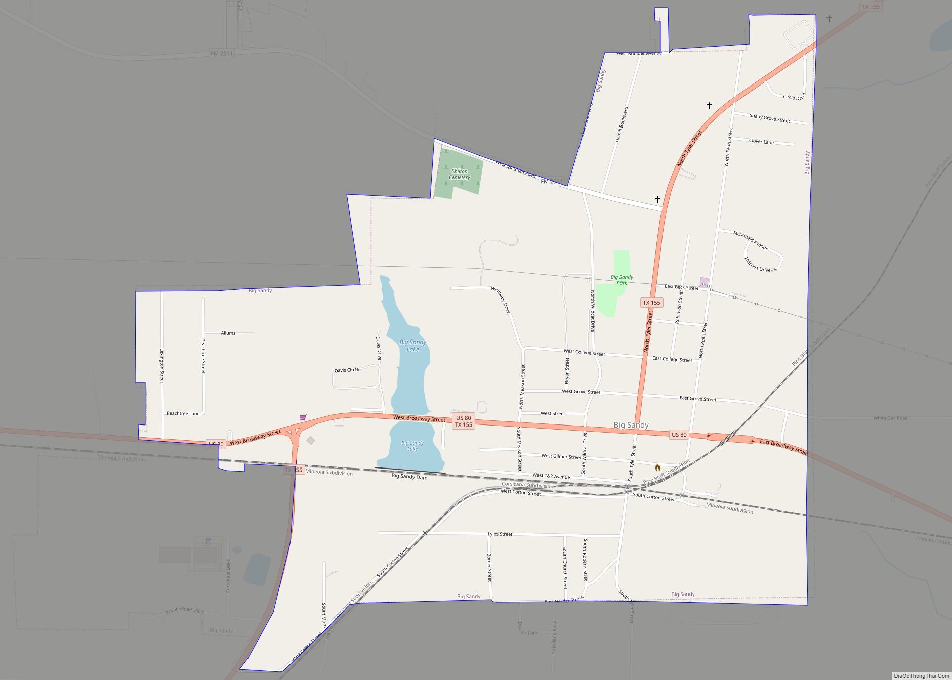
Map of Benjamin city

Map of Benjamin city, Texas

Benjamin is a city in and the county seat of Knox County, Texas, United States. Its population was 258 at the 2010 census. Benjamin city overview: Name: Benjamin city LSAD Code: 25 LSAD Description: city (suffix) State: Texas County: Knox County Elevation: 1,476 ft (450 m) Total Area: 1.05 sq mi (2.72 km²) Land Area: 1.05 sq mi (2.72 km²) Water Area: 0.00 sq mi … Read more

Map of Benjamin Perez CDP

Map of Benjamin Perez CDP

Benjamin Perez is a census-designated place (CDP) in Starr County, Texas, United States. This was a new CDP for the 2010 census with a population of 34. Benjamin Perez CDP overview: Name: Benjamin Perez CDP LSAD Code: 57 LSAD Description: CDP (suffix) State: Texas County: Starr County Total Area: 34 FIPS code: 4807642 Online Interactive … Read more

Map of Bloomburg town

Map of Bloomburg town

Bloomburg is a town in Cass County, Texas, United States. Bloomburg is 7 miles (11 km) east of Atlanta, Texas, and is home to the Cullen Baker Country Fair, held every year on the first Saturday in November. Despite it being named after an outlaw named Cullen Baker, it is a huge family event and has … Read more

Map of Blessing CDP

Map of Blessing CDP

Blessing is a census-designated place (CDP) in Matagorda County, Texas, United States. Blessing had its start when the railroad finally was extended to that point, and first settlers accepted the name “Blessing” after their first choice of “Thank God” was deemed unsuitable by postal officials. A post office called Blessing has been in operation since … Read more

Map of Blanket town

Map of Blanket town

Blanket is a town located in Brown County in west-central Texas, United States. The population was 390 at the 2010 census. The town takes its name from nearby Blanket Creek. Blanket town overview: Name: Blanket town LSAD Code: 43 LSAD Description: town (suffix) State: Texas County: Brown County Elevation: 1,621 ft (494 m) Total Area: 0.65 sq mi (1.67 km²) … Read more

Map of Blanco city, Texas

Map of Blanco city, Texas

Blanco (Spanish: “white”, /ˈblæŋkoʊ/ BLANG-koh) is a city in rural Blanco County, Texas, United States. The population was 1,739 at the 2010 census. Blanco is a cattle and ranching community. Blanco city overview: Name: Blanco city LSAD Code: 25 LSAD Description: city (suffix) State: Texas County: Blanco County Elevation: 1,329 ft (405 m) Total Area: 3.54 sq mi (9.18 km²) … Read more

Map of Blackwell city, Texas

Map of Blackwell city, Texas

Blackwell is a city in Coke and Nolan Counties in the U.S. state of Texas. Its population was 311 at the 2010 census. Blackwell city overview: Name: Blackwell city LSAD Code: 25 LSAD Description: city (suffix) State: Texas County: Coke County, Nolan County Elevation: 2,126 ft (648 m) Total Area: 0.59 sq mi (1.53 km²) Land Area: 0.59 sq mi (1.53 km²) Water … Read more

Map of Bixby CDP, Texas

Map of Bixby CDP, Texas

Bixby is a census-designated place (CDP) in Cameron County, Texas, United States. The population was 504 at the 2010 census. It is part of the Brownsville–Harlingen Metropolitan Statistical Area. Bixby CDP overview: Name: Bixby CDP LSAD Code: 57 LSAD Description: CDP (suffix) State: Texas County: Cameron County Elevation: 59 ft (18 m) Total Area: 1.6 sq mi (4.3 km²) Land … Read more

Map of Bishop city, Texas

Map of Bishop city, Texas

Bishop is a city in Nueces County, Texas, United States. The population was 3,134 in the 2010 census, down from 3305 in 2000 census. Bishop city overview: Name: Bishop city LSAD Code: 25 LSAD Description: city (suffix) State: Texas County: Nueces County Elevation: 59 ft (18 m) Total Area: 2.41 sq mi (6.25 km²) Land Area: 2.41 sq mi (6.25 km²) Water Area: … Read more

Map of Bishop Hills town

Map of Bishop Hills town

Bishop Hills is a town in Potter County, Texas, United States. The population was 193 at the 2010 census. It is part of the Amarillo, Texas Metropolitan Statistical Area. Bishop Hills town overview: Name: Bishop Hills town LSAD Code: 43 LSAD Description: town (suffix) State: Texas County: Potter County Elevation: 3,488 ft (1,063 m) Total Area: 0.31 sq mi … Read more

Map of Bigfoot CDP

Map of Bigfoot CDP

Bigfoot is an unincorporated community and census-designated place (CDP) in Frio County, Texas, United States. The population was 450 at the 2010 census, up from 304 at the 2000 census. Bigfoot CDP overview: Name: Bigfoot CDP LSAD Code: 57 LSAD Description: CDP (suffix) State: Texas County: Frio County Elevation: 650 ft (198 m) Total Area: 23.92 sq mi (61.96 km²) … Read more

Map of Big Wells city

Map of Big Wells city

Big Wells is a city in Dimmit County, Texas, United States. The population was 697 at the 2010 census, with an estimated population of 712 in 2018. Big Wells city overview: Name: Big Wells city LSAD Code: 25 LSAD Description: city (suffix) State: Texas County: Dimmit County Elevation: 522 ft (159 m) Total Area: 0.56 sq mi (1.44 km²) Land … Read more