Map of Edgewood town, Texas

Map of Edgewood town, Texas

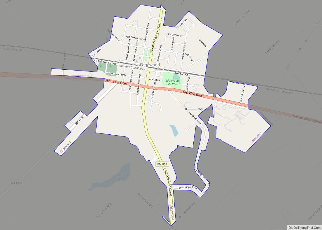
Edgewood is a city in Van Zandt County, Texas, United States. The population was 1,441 at the 2010 census. The town draws its name from its location on the far western edge of the East Texas timberline on U.S. Highway 80, approximately 60 miles east of Dallas. Edgewood town overview: Name: Edgewood town LSAD Code: … Read more

Map of Edgewater Estates CDP

Map of Edgewater Estates CDP

Edgewater Estates is a census-designated place (CDP) in San Patricio County, Texas, United States. The population was 72 at the 2010 census. Prior to the 2010 census Edgewater Estates was part of the Edgewater-Paisano CDP. Edgewater Estates CDP overview: Name: Edgewater Estates CDP LSAD Code: 57 LSAD Description: CDP (suffix) State: Texas County: San Patricio … Read more

Map of El Lago city

Map of El Lago city

El Lago is a city in Harris County, Texas, United States. The population was 3,090 at the 2020 census. El Lago has particular historical significance as it sits on the site of one of the main hide-outs for the French pirate and privateer Jean Lafitte. El Lago city overview: Name: El Lago city LSAD Code: … Read more

Map of El Indio CDP

Map of El Indio CDP

El Indio (/ɛlˈaɪndiːoʊ/, Spanish pronunciation: [eˈlindjo]) is a census-designated place (CDP) in Maverick County, Texas, United States. The population was 263 at the 2000 census. El Indio CDP overview: Name: El Indio CDP LSAD Code: 57 LSAD Description: CDP (suffix) State: Texas County: Maverick County Elevation: 735 ft (224 m) Total Area: 1.8 sq mi (4.6 km²) Land Area: 1.8 sq mi (4.6 km²) … Read more

Map of El Chaparral CDP

Map of El Chaparral CDP

El Chaparral is a census-designated place (CDP) in Starr County, Texas, United States. It is a new CDP for 2010 census with a population of 464. It was formed along with Santa Rosa CDP from the old Santa Cruz CDP. (Not to confused with the new Santa Cruz CDP.) El Chaparral CDP overview: Name: El … Read more

Map of El Cenizo CDP

Map of El Cenizo CDP

El Cenizo is a census-designated place (CDP) in Starr County, Texas, United States. It is a new CDP formed from part of the La Rosita CDP prior to the 2010 census with a population of 249. El Cenizo CDP overview: Name: El Cenizo CDP LSAD Code: 57 LSAD Description: CDP (suffix) State: Texas County: Starr … Read more

Map of El Castillo CDP

Map of El Castillo CDP

El Castillo (in Spanish: Castle) is a census-designated place located in Starr County, Texas. It is a new CDP formed from part of the old La Victoria CDP for the 2010 census with a population of 188. El Castillo CDP overview: Name: El Castillo CDP LSAD Code: 57 LSAD Description: CDP (suffix) State: Texas County: … Read more

Map of El Campo city

Map of El Campo city

El Campo is a city in Wharton County, Texas, United States. The population was 12,350 at the 2020 Census, making it the largest city in Wharton County. El Campo city overview: Name: El Campo city LSAD Code: 25 LSAD Description: city (suffix) State: Texas County: Wharton County Elevation: 105 ft (32 m) Total Area: 9.78 sq mi (25.33 km²) Land … Read more

Map of El Refugio CDP

Map of El Refugio CDP

El Refugio (“The Refuge”) is a census-designated place (CDP) in Starr County, Texas, United States. The population was 331 at the 2010 census. El Refugio gained area in the 2010 census. El Refugio CDP overview: Name: El Refugio CDP LSAD Code: 57 LSAD Description: CDP (suffix) State: Texas County: Starr County Elevation: 151 ft (46 m) Total … Read more

Map of El Rancho Vela CDP

Map of El Rancho Vela CDP

El Rancho Vela is a census-designated place (CDP) in Starr County, Texas, United States. This was a new CDP for the 2010 census with a population of 274. El Rancho Vela CDP overview: Name: El Rancho Vela CDP LSAD Code: 57 LSAD Description: CDP (suffix) State: Texas County: Starr County Total Area: 0.1 sq mi (0.3 km²) Land … Read more

Map of El Quiote CDP

Map of El Quiote CDP

El Quiote is a census-designated place (CDP) in Starr County, Texas, United States. It is a new CDP formed from part of the Los Alvarez CDP prior to the 2010 census with a population of 208. El Quiote CDP overview: Name: El Quiote CDP LSAD Code: 57 LSAD Description: CDP (suffix) State: Texas County: Starr … Read more

Map of El Mesquite CDP

Map of El Mesquite CDP

El Mesquite is a census-designated place (CDP) in Starr County, Texas, United States. This was a new CDP for the 2010 census with a population of 38. El Mesquite CDP overview: Name: El Mesquite CDP LSAD Code: 57 LSAD Description: CDP (suffix) State: Texas County: Starr County Total Area: 38 FIPS code: 4823278 Online Interactive … Read more