Map of Elmo CDP, Texas

Map of Elmo CDP, Texas

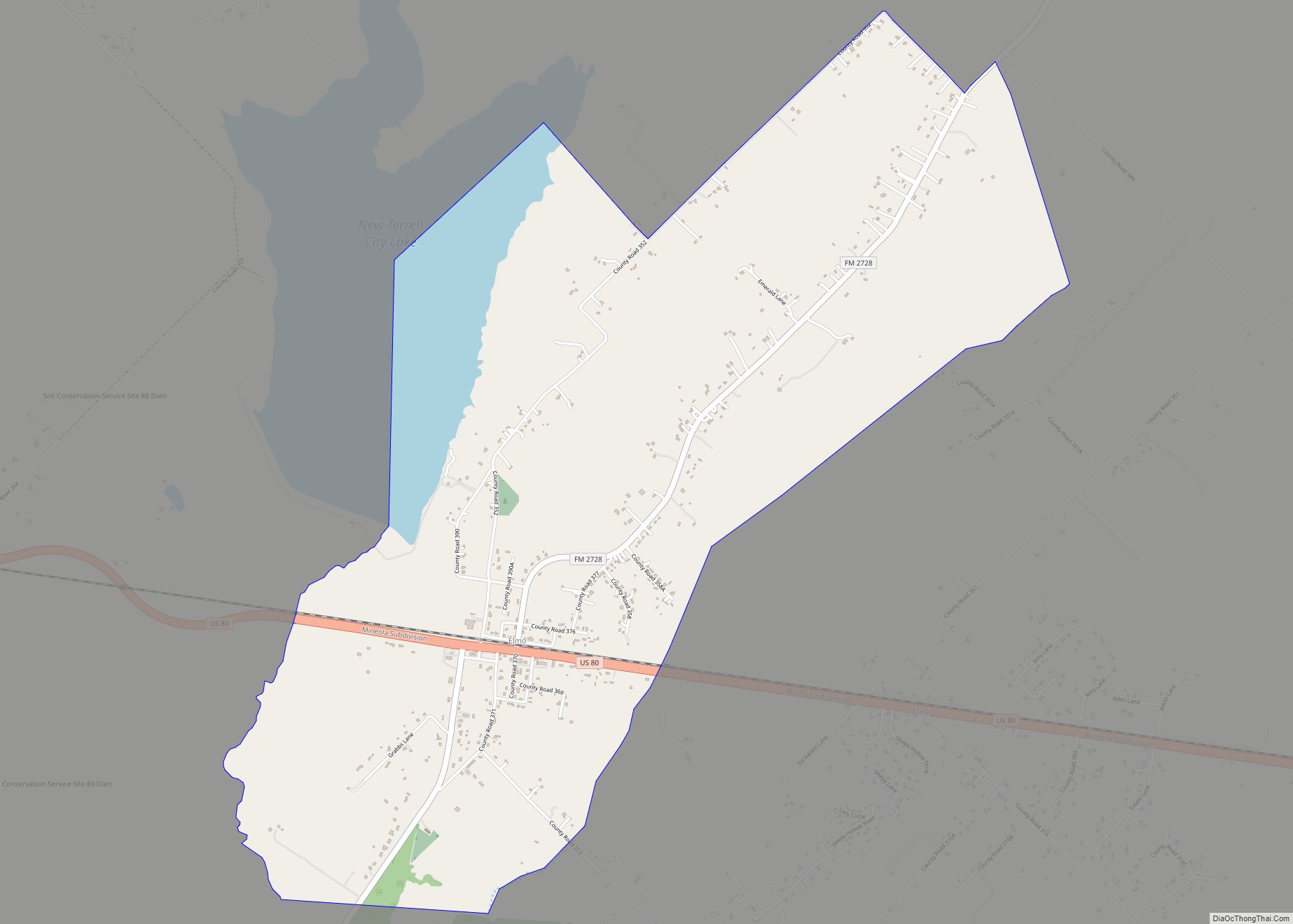
Elmo is a census-designated place and unincorporated community in Kaufman County, Texas, United States. It is located on U.S. Highway 80, 6 miles (10 km) east of Terrell and 13 miles (21 km) northeast of Kaufman, the county seat. The population was 768 at the 2010 Census. Elmo CDP overview: Name: Elmo CDP LSAD Code: 57 LSAD … Read more

Map of Elmendorf city

Map of Elmendorf city

Elmendorf is a city in Bexar County, Texas, United States. It is part of the San Antonio—New Braunfels metropolitan statistical area. Its population was 1,862 at the 2020 census. It was founded in 1885, and named after Henry Elmendorf, a former mayor of San Antonio, and a German-Texan. For a long time, the biggest employer … Read more

Map of Elm Creek CDP, Texas

Map of Elm Creek CDP, Texas

Elm Creek is a census-designated place (CDP) in Maverick County, Texas, United States. The population was 2,469 at the 2010 census. Elm Creek CDP overview: Name: Elm Creek CDP LSAD Code: 57 LSAD Description: CDP (suffix) State: Texas County: Maverick County Elevation: 751 ft (229 m) Total Area: 2.8 sq mi (7.3 km²) Land Area: 2.8 sq mi (7.3 km²) Water Area: 0.0 sq mi … Read more

Map of Elkhart town, Texas

Map of Elkhart town, Texas

Elkhart is a town the U.S. state of Texas, in Anderson County. Named for a friendly Native American who assisted the early settlers of the area, Elkhart’s population was 1,287 at the 2020 U.S. census. Elkhart town overview: Name: Elkhart town LSAD Code: 43 LSAD Description: town (suffix) State: Texas County: Anderson County Elevation: 384 ft … Read more

Map of Elias-Fela Solis CDP

Map of Elias-Fela Solis CDP

Elias-Fela Solis is a census-designated place (CDP) in Starr County, Texas, United States. This was a new CDP for the 2010 census with a population of 30. Elias-Fela Solis CDP overview: Name: Elias-Fela Solis CDP LSAD Code: 57 LSAD Description: CDP (suffix) State: Texas County: Starr County Total Area: 0.2 sq mi (0.5 km²) Land Area: 0.2 sq mi (0.5 km²) … Read more

Map of Elgin city, Texas

Map of Elgin city, Texas

Elgin (/ˈɛlɡɪn/ EL-ghin) is a city in Bastrop County in the U.S. state of Texas. The population was 9,784 at the 2020 census. Elgin is also known as the Sausage Capital of Texas and the Brick Capital of the Southwest, due to the presence of three operating brickyards in the mid-20th century (two of which … Read more

Map of Electra city

Map of Electra city

Electra is a city in Wichita County, Texas, United States. It is part of the Wichita Falls metropolitan statistical area. The population was 2,791 at the 2010 census., down from 3,168 in 2000. Electra claims the title of Pump Jack Capital of Texas, a title made official by the state in 2001, and has celebrated … Read more

Map of Eldorado city, Texas

Map of Eldorado city, Texas

Eldorado (/ˌɛldəˈrɑːdoʊ/ EL-də-RAH-doh, /-ˈreɪdoʊ/ -RAY-doh) is a city in and the county seat of Schleicher County, Texas, United States. The population was 1,951 at the 2010 census. Eldorado is located on U.S. Highway 277 some 21 miles (34 km) north of Sonora and 43 miles (69 km) south of San Angelo, Texas. Eldorado city overview: Name: Eldorado … Read more

Map of Elbert CDP, Texas

Map of Elbert CDP, Texas

Elbert is a census-designated place (CDP) in Throckmorton County, Texas, United States. The population was 30 at the 2010 census. Elbert CDP overview: Name: Elbert CDP LSAD Code: 57 LSAD Description: CDP (suffix) State: Texas County: Throckmorton County Elevation: 1,155 ft (352 m) Total Area: 6.0 sq mi (15.5 km²) Land Area: 6.0 sq mi (15.5 km²) Water Area: 0.0 sq mi (0.0 km²) Total Population: … Read more

Map of El Socio CDP

Map of El Socio CDP

El Socio is a census-designated place (CDP) in Starr County, Texas, United States. It is a new CDP formed from part of the old La Victoria CDP prior to the 2010 census with a population of 130. El Socio CDP overview: Name: El Socio CDP LSAD Code: 57 LSAD Description: CDP (suffix) State: Texas County: … Read more

Map of Enchanted Oaks town

Map of Enchanted Oaks town

Enchanted Oaks is a town in Henderson County, Texas, United States. The population was 326 at the 2010 census, down from 357 at the 2000 census. Enchanted Oaks town overview: Name: Enchanted Oaks town LSAD Code: 43 LSAD Description: town (suffix) State: Texas County: Henderson County Elevation: 345 ft (105 m) Total Area: 0.40 sq mi (1.02 km²) Land Area: … Read more

Map of Encantada-Ranchito-El Calaboz CDP

Map of Encantada-Ranchito-El Calaboz CDP

Encantada-Ranchito-El Calaboz, also known as El Calaboz Rancheria in the San Pedro de Carricitos Land Grant, is a census-designated place (CDP) in Cameron County, Texas, United States. The population was 2,255 at the 2010 census. It is part of the Brownsville–Harlingen Metropolitan Statistical Area. Encantada-Ranchito-El Calaboz CDP overview: Name: Encantada-Ranchito-El Calaboz CDP LSAD Code: 57 … Read more