Map of Lake Dallas city

Map of Lake Dallas city

Lake Dallas is a city in Denton County, Texas, United States. It is located in North Texas, northwest of the city of Dallas, on the shores of Lewisville Lake. The community’s name derives from the original name of the lake. It is also one of the 4 communities in the Lake Cities. Lake Dallas city … Read more

Map of Lake Colorado City CDP

Map of Lake Colorado City CDP

Lake Colorado City is an unincorporated community and census-designated place in Mitchell County, Texas, United States. Its population was 588 as of the 2010 census. Lake Colorado City CDP overview: Name: Lake Colorado City CDP LSAD Code: 57 LSAD Description: CDP (suffix) State: Texas County: Mitchell County Elevation: 2,083 ft (635 m) Total Area: 9.121 sq mi (23.62 km²) Land … Read more

Map of Lake City town, Texas

Map of Lake City town, Texas

Lake City is a town in San Patricio County, Texas, United States. The population was 509 at the 2010 census. Lake City town overview: Name: Lake City town LSAD Code: 43 LSAD Description: town (suffix) State: Texas County: San Patricio County Elevation: 118 ft (36 m) Total Area: 0.75 sq mi (1.95 km²) Land Area: 0.73 sq mi (1.89 km²) Water Area: 0.03 sq mi … Read more

Map of Lake Cherokee CDP

Map of Lake Cherokee CDP

Lake Cherokee is an unincorporated community and census-designated place (CDP) in Gregg and Rusk counties, Texas, United States. Its population was 2,980 as of the 2020 census. Lake Cherokee is located 12 miles Southeast of Gregg and Northeastern Rusk counties on Cherokee Bayou. The lake is owned by the Cherokee Water Company to supply water … Read more

Map of Lake Bryan CDP

Map of Lake Bryan CDP

Lake Bryan is a census-designated place (CDP) in Brazos County, Texas, United States, situated around a reservoir of the same name managed by Bryan Texas Utilities. The population was 2,060 at the 2020 census. It is part of the Bryan–College Station metropolitan area. Lake Bryan CDP overview: Name: Lake Bryan CDP LSAD Code: 57 LSAD … Read more

Map of Lake Brownwood CDP

Map of Lake Brownwood CDP

Lake Brownwood is a census-designated place (CDP) located in Brown County in central Texas, United States. The population was 1,532 at the 2010 census. Lake Brownwood CDP overview: Name: Lake Brownwood CDP LSAD Code: 57 LSAD Description: CDP (suffix) State: Texas County: Brown County Elevation: 1,444 ft (440 m) Total Area: 6.8 sq mi (17.5 km²) Land Area: 5.7 sq mi (14.7 km²) … Read more

Map of Lake Bridgeport city

Map of Lake Bridgeport city

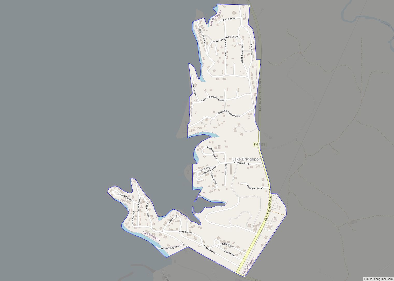
Lake Bridgeport is a city in Wise County, Texas, United States. The population was 339 in 2020. Lake Bridgeport city overview: Name: Lake Bridgeport city LSAD Code: 25 LSAD Description: city (suffix) State: Texas County: Wise County Elevation: 912 ft (278 m) Total Area: 0.47 sq mi (1.21 km²) Land Area: 0.47 sq mi (1.21 km²) Water Area: 0.00 sq mi (0.00 km²) Total Population: 339 … Read more

Map of Laguna Vista town

Map of Laguna Vista town

Laguna Vista is a town in Cameron County, Texas, United States. The population was 3,117 at the 2010 census. It is included as part of the Brownsville–Harlingen–Raymondville and the Matamoros–Brownsville metropolitan areas. Laguna Vista town overview: Name: Laguna Vista town LSAD Code: 43 LSAD Description: town (suffix) State: Texas County: Cameron County Elevation: 10 ft (3 m) … Read more

Map of Laguna Seca CDP

Map of Laguna Seca CDP

Laguna Seca is a census-designated place (CDP) in Hidalgo County, Texas. The population was 266 at the 2010 United States Census. It is part of the McAllen–Edinburg–Mission Metropolitan Statistical Area. Laguna Seca CDP overview: Name: Laguna Seca CDP LSAD Code: 57 LSAD Description: CDP (suffix) State: Texas County: Hidalgo County Elevation: 105 ft (32 m) Total Area: … Read more

Map of Laguna Park CDP

Map of Laguna Park CDP

Laguna Park is an unincorporated community and census-designated place (CDP) in Bosque County in central Texas, United States. As of the 2010 census, it had a population of 1,276. Laguna Park is located along State Highway 22 in southeastern Bosque County, approximately 27 miles (43 km) northwest of Waco. The community is situated at the southern … Read more

Map of Lake Meredith Estates CDP

Map of Lake Meredith Estates CDP

Lake Meredith Estates is an unincorporated community and census-designated place in Hutchinson County, Texas, United States. Its population was 437 as of the 2010 census. Lake Meredith Estates CDP overview: Name: Lake Meredith Estates CDP LSAD Code: 57 LSAD Description: CDP (suffix) State: Texas County: Hutchinson County Elevation: 3,137 ft (956 m) Total Area: 0.834 sq mi (2.16 km²) Land … Read more

Map of Lake Medina Shores CDP

Map of Lake Medina Shores CDP

Lake Medina Shores is a census-designated place in Bandera and Medina counties, Texas, United States. Its population was 1,235 as of the 2010 census. This was a new CDP for the 2010 census. Lake Medina Shores CDP overview: Name: Lake Medina Shores CDP LSAD Code: 57 LSAD Description: CDP (suffix) State: Texas County: Bandera County, … Read more