Map of Annetta North town

Map of Annetta North town

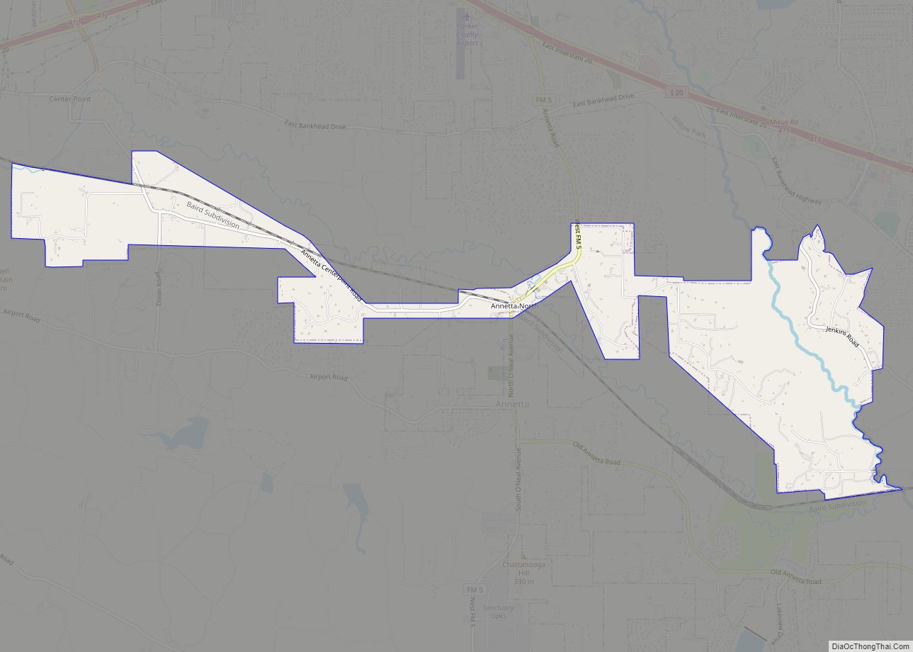
Annetta North is a town in eastern Parker County, Texas, United States, on FM 5. The population was 518 at the 2010 census. The Town of Annetta North split from Annetta and was incorporated on August 11, 1979. Phyllis M. Studer was elected as its first mayor. As of April 2018 the mayor is Robert Schmidt. … Read more

Map of Aransas Pass city

Map of Aransas Pass city

Aransas Pass (/əˈrænzəs/ ə-RAN-zəs) is a city in Aransas, Nueces, and San Patricio Counties in the U.S. state of Texas. The population was 7,941 at the 2020 Census. Aransas Pass city overview: Name: Aransas Pass city LSAD Code: 25 LSAD Description: city (suffix) State: Texas County: Aransas County, Nueces County, San Patricio County Elevation: 16 ft … Read more

Map of Aquilla city, Texas

Map of Aquilla city, Texas

Aquilla (/əˈkwɪlə/ ə-KWIL-ə) is a city located in Hill County, Texas, United States. It is located on Farm Road 933 16 miles (26 km) southwest of Hillsboro. The population was 109 at the 2010 census. Aquilla city overview: Name: Aquilla city LSAD Code: 25 LSAD Description: city (suffix) State: Texas County: Hill County Elevation: 522 ft (159 m) … Read more

Map of Appleby city

Map of Appleby city

Appleby is a city in Nacogdoches County, in the U.S. state of Texas. The population was 474 at the 2010 census. Appleby city overview: Name: Appleby city LSAD Code: 25 LSAD Description: city (suffix) State: Texas County: Nacogdoches County Elevation: 410 ft (120 m) Total Area: 2.15 sq mi (5.58 km²) Land Area: 2.15 sq mi (5.58 km²) Water Area: 0.00 sq mi (0.00 km²) Total … Read more

Map of Athens city, Texas

Map of Athens city, Texas

Athens is a city and the county seat of Henderson County, Texas, in the United States. As of the 2020 census, the city population was 12,857. The city has called itself the “Black-Eyed Pea Capital of the World.” Athens was selected as one of the first “Certified Retirement Communities” in Texas. It was named after … Read more

Map of Atascocita CDP

Map of Atascocita CDP

Atascocita is a census-designated place (CDP) in Harris County, Texas, United States, within the Houston metropolitan area. As of the 2020 census it had a population of 88,174. It is located north and south of Farm to Market Road 1960 about 6 miles (10 km) east of Humble and 18 miles (29 km) northeast of downtown Houston … Read more

Map of Aspermont town

Map of Aspermont town

Aspermont is a town in the U.S. state of Texas, and is the county seat of Stonewall County. The population was 835 at the 2019 census. Aspermont town overview: Name: Aspermont town LSAD Code: 43 LSAD Description: town (suffix) State: Texas County: Stonewall County Elevation: 1,781 ft (543 m) Total Area: 2.07 sq mi (5.37 km²) Land Area: 2.05 sq mi (5.32 km²) … Read more

Map of Asherton city

Map of Asherton city

Asherton is a city in Dimmit County, Texas, United States. The population was 1,084 at the 2010 census, down from 1,342 at the 2000 census. The estimated population in 2018 was 1,064. U.S. Highway 83 runs through Asherton. Asherton city overview: Name: Asherton city LSAD Code: 25 LSAD Description: city (suffix) State: Texas County: Dimmit … Read more

Map of Arroyo Gardens CDP

Map of Arroyo Gardens CDP

Arroyo Gardens is a census-designated place (CDP) in Cameron County, in the U.S. state of Texas. The population was 456 at the 2010 census. Prior to the 2010 census the community was part of the Arroyo Gardens-La Tina Ranch CDP. It is part of the Brownsville–Harlingen Metropolitan Statistical Area. Arroyo Gardens CDP overview: Name: Arroyo … Read more

Map of Arroyo Colorado Estates CDP

Map of Arroyo Colorado Estates CDP

Arroyo Colorado Estates is a census-designated place (CDP) in Cameron County, in the U.S. state of Texas. The population was 997 at the 2010 census. It is part of the Brownsville–Harlingen Metropolitan Statistical Area. Arroyo Colorado Estates CDP overview: Name: Arroyo Colorado Estates CDP LSAD Code: 57 LSAD Description: CDP (suffix) State: Texas County: Cameron … Read more

Map of Arp city

Map of Arp city

Arp is a city in Smith County, in the U.S. state of Texas. It is part of the Tyler metropolitan statistical area. According to the United States Census Bureau. The population was 892 in the 2020 census. Arp city overview: Name: Arp city LSAD Code: 25 LSAD Description: city (suffix) State: Texas County: Smith County … Read more

Map of Argyle city, Texas

Map of Argyle city, Texas

Argyle is a city in Denton County, Texas, United States, with a population of 4,403 as of 2020. It is a suburb of Fort Worth. Argyle city overview: Name: Argyle city LSAD Code: 25 LSAD Description: city (suffix) State: Texas County: Denton County Elevation: 719 ft (219 m) Total Area: 11.61 sq mi (30.06 km²) Land Area: 11.56 sq mi (29.93 km²) Water … Read more