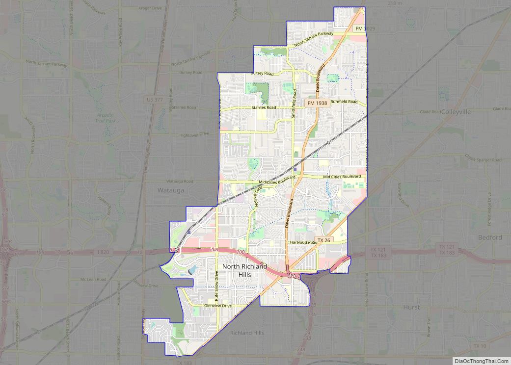
Map of Northlake town, Texas

Map of Northlake town, Texas

Northlake is a town in Denton County, Texas, United States. The population was 5,201 in 2020. The town is located northwest of Grapevine Lake, approximately 10 miles (16 km) northwest of Westlake, Texas. Northlake town overview: Name: Northlake town LSAD Code: 43 LSAD Description: town (suffix) State: Texas County: Denton County Elevation: 689 ft (210 m) Total Area: … Read more

Map of North San Pedro CDP

Map of North San Pedro CDP

North San Pedro is a census-designated place (CDP) in Nueces County, Texas, United States. The population was 895 at the 2010 census, down from 920 at the 2000 census. North San Pedro CDP overview: Name: North San Pedro CDP LSAD Code: 57 LSAD Description: CDP (suffix) State: Texas County: Nueces County Elevation: 79 ft (24 m) Total … Read more

Map of Oak Trail Shores CDP

Map of Oak Trail Shores CDP

Oak Trail Shores is an unincorporated community and census-designated place (CDP) in Hood County, Texas, United States. Its population was 2,755 at the 2010 census. It is part of the Granbury micropolitan area as well as the Dallas–Fort Worth metroplex. Oak Trail Shores CDP overview: Name: Oak Trail Shores CDP LSAD Code: 57 LSAD Description: … Read more

Map of Oak Ridge town, Texas

Map of Oak Ridge town, Texas

Oak Ridge is a town in Kaufman County, Texas, United States. The population was 495 at the 2010 census, up from 400 at the 2000 census. Oak Ridge town overview: Name: Oak Ridge town LSAD Code: 43 LSAD Description: town (suffix) State: Texas County: Kaufman County Elevation: 432 ft (132 m) Total Area: 3.06 sq mi (7.93 km²) Land Area: … Read more

Map of Oak Ridge North city

Map of Oak Ridge North city

Oak Ridge North (commonly referred to as Oak Ridge) is a city in Montgomery County, Texas, United States. It is located along Interstate 45 10 miles (16 km) south of Conroe and 35 miles north of Houston. The population was 3,057 at the 2020 census. Oak Ridge North city overview: Name: Oak Ridge North city LSAD … Read more

Map of Oak Point city

Map of Oak Point city

Oak Point is a city in Denton County, Texas, United States. Ranked in the Top 20 of 62 suburbs in the Dallas area by D Magazine, Oak Point had a population of 2,786 at the 2010 census. Oak Point city overview: Name: Oak Point city LSAD Code: 25 LSAD Description: city (suffix) State: Texas County: … Read more

Map of Oak Leaf city

Map of Oak Leaf city

Oak Leaf is a city in Ellis County, Texas, United States. The population was 1,298 at the 2010 census. Oak Leaf city overview: Name: Oak Leaf city LSAD Code: 25 LSAD Description: city (suffix) State: Texas County: Ellis County Elevation: 604 ft (184 m) Total Area: 2.37 sq mi (6.13 km²) Land Area: 2.36 sq mi (6.12 km²) Water Area: 0.00 sq mi (0.01 km²) Total … Read more

Map of Oak Island CDP, Texas

Map of Oak Island CDP, Texas

Oak Island is an unincorporated community and census-designated place (CDP) in Chambers County, Texas, United States. The population was 371 at the 2020 census. Oak Island CDP overview: Name: Oak Island CDP LSAD Code: 57 LSAD Description: CDP (suffix) State: Texas County: Chambers County Elevation: 8 ft (2 m) Total Area: 1.20 sq mi (3.11 km²) Land Area: 1.20 sq mi (3.11 km²) … Read more

Map of Oak Grove town, Texas

Map of Oak Grove town, Texas

Oak Grove is a town in Kaufman County, Texas, United States. The population was 603 at the 2010 census. Oak Grove town overview: Name: Oak Grove town LSAD Code: 43 LSAD Description: town (suffix) State: Texas County: Kaufman County Elevation: 420 ft (128 m) Total Area: 1.96 sq mi (5.08 km²) Land Area: 1.96 sq mi (5.08 km²) Water Area: 0.00 sq mi (0.00 km²) Total … Read more

Map of O'Donnell city

Map of O’Donnell city

O’Donnell is a West Texas city that lies primarily in Lynn County, with a small portion extending south into Dawson County, Texas. Its population was 831 at the 2010 census, down from 1,011 at the 2000 census. The Lynn county portion of O’Donnell is part of the Lubbock Metropolitan area. O’Donnell city overview: Name: O’Donnell … Read more

Map of O'Brien city, Texas

Map of O’Brien city, Texas

O’Brien is a city in Haskell County, Texas, United States. The population was 132 at the time of the 2000 census. As of 2010, the O’Brien population was 106. O’Brien is located at the junction of Farm Road 2229 and Texas State Highway 6; the nearest large city is Abilene, 70 miles to the south. … Read more

Map of Novice city

Map of Novice city

Novice is a city in Coleman County, Texas, United States. Its population was 139 at the 2010 census. Novice city overview: Name: Novice city LSAD Code: 25 LSAD Description: city (suffix) State: Texas County: Coleman County Elevation: 1,982 ft (604 m) Total Area: 0.48 sq mi (1.25 km²) Land Area: 0.48 sq mi (1.25 km²) Water Area: 0.00 sq mi (0.00 km²) Total Population: 139 Population … Read more