Map of Old River-Winfree city

Map of Old River-Winfree city

Old River-Winfree is a city in Chambers and Liberty counties, Texas, United States. The population was 1,315 at the 2020 census. Old River-Winfree city overview: Name: Old River-Winfree city LSAD Code: 25 LSAD Description: city (suffix) State: Texas County: Chambers County, Liberty County Elevation: 36 ft (11 m) Total Area: 1.57 sq mi (4.06 km²) Land Area: 1.57 sq mi (4.06 km²) Water … Read more

Map of Oilton CDP, Texas

Map of Oilton CDP, Texas

Oilton is a census-designated place (CDP) in Webb County, Texas, United States. The population was 152 at the 2010 census. The community is within the boundary of Webb Consolidated Independent School District and is home to the Oilton Elementary School. Oilton CDP overview: Name: Oilton CDP LSAD Code: 57 LSAD Description: CDP (suffix) State: Texas … Read more

Map of Oglesby city, Texas

Map of Oglesby city, Texas

Oglesby is a city in Coryell County, Texas, United States. The population was 484 at the 2010 census. It is part of the Killeen–Temple–Fort Hood Metropolitan Statistical Area. Oglesby city overview: Name: Oglesby city LSAD Code: 25 LSAD Description: city (suffix) State: Texas County: Coryell County Elevation: 846 ft (258 m) Total Area: 0.51 sq mi (1.32 km²) Land Area: … Read more

Map of Odem city

Map of Odem city

Odem is a city in San Patricio County, Texas, United States. Its population was 2,389 at the 2010 census. Odem city overview: Name: Odem city LSAD Code: 25 LSAD Description: city (suffix) State: Texas County: San Patricio County Elevation: 72 ft (22 m) Total Area: 1.27 sq mi (3.30 km²) Land Area: 1.27 sq mi (3.30 km²) Water Area: 0.00 sq mi (0.00 km²) Total Population: … Read more

Map of Oakwood town, Texas

Map of Oakwood town, Texas

Oakwood is a town in Leon and Freestone counties in the U.S. state of Texas. The population was 389 at the 2020 census. It was founded in 1872 as a stop on the International Railroad. Oakwood town overview: Name: Oakwood town LSAD Code: 43 LSAD Description: town (suffix) State: Texas County: Freestone County, Leon County … Read more

Map of Oakhurst CDP, Texas

Map of Oakhurst CDP, Texas

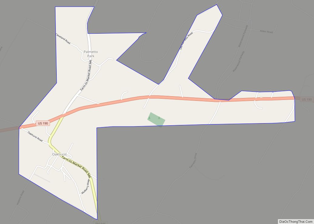
Oakhurst is a census-designated place and unincorporated community in San Jacinto County, Texas, United States. The population was 233 at the 2010 census. Prior to the 2010 census Oakhurst and Cape Royale CDPs were part of Oakhurst city, which has been disincorporated. Oakhurst CDP overview: Name: Oakhurst CDP LSAD Code: 57 LSAD Description: CDP (suffix) … Read more

Map of Oak Valley town, Texas

Map of Oak Valley town, Texas

Oak Valley is a town in Navarro County, Texas, United States. The population was 368 at the 2010 census. Oak Valley town overview: Name: Oak Valley town LSAD Code: 43 LSAD Description: town (suffix) State: Texas County: Navarro County Elevation: 420 ft (128 m) Total Area: 1.97 sq mi (5.09 km²) Land Area: 1.94 sq mi (5.01 km²) Water Area: 0.03 sq mi (0.08 km²) Total … Read more

Map of Olmito and Olmito CDP

Map of Olmito and Olmito CDP

Olmito and Olmito is a census-designated place (CDP) in Starr County, Texas, United States. It is a new CDP formed from part of the old La Victoria CDP prior to the 2010 census with a population of 271. Olmito and Olmito CDP overview: Name: Olmito and Olmito CDP LSAD Code: 57 LSAD Description: CDP (suffix) … Read more

Map of Olivia Lopez de Gutierrez CDP

Map of Olivia Lopez de Gutierrez CDP

Olivia Lopez de Gutierrez is a census-designated place (CDP) in Starr County, Texas, United States. It is a new CDP formed from part of the former La Casita-Garciasville CDP prior to the 2010 census with a population of 93. Olivia Lopez de Gutierrez CDP overview: Name: Olivia Lopez de Gutierrez CDP LSAD Code: 57 LSAD … Read more

Map of Olivarez CDP

Map of Olivarez CDP

Olivarez is a census-designated place (CDP) in Hidalgo County, Texas. The population was 3,827 at the 2010 United States Census. It is part of the McAllen–Edinburg–Mission Metropolitan Statistical Area. Olivarez CDP overview: Name: Olivarez CDP LSAD Code: 57 LSAD Description: CDP (suffix) State: Texas County: Hidalgo County Elevation: 66 ft (20 m) Total Area: 3.7 sq mi (9.5 km²) Land … Read more

Map of Orason CDP

Map of Orason CDP

Orason is a census-designated place (CDP) in Cameron County, in the U.S. state of Texas. The population was 129 at the 2010 census. Prior to the 2010 census the community was part of the Chula Vista-Orason CDP. It is part of the Brownsville–Harlingen Metropolitan Statistical Area. Orason CDP overview: Name: Orason CDP LSAD Code: 57 … Read more

Map of Orange city, Texas

Map of Orange city, Texas

Orange is a city and the county seat of Orange County, Texas, United States. As of the 2020 census, the city population was 19,324. It is the easternmost city in Texas, located on the Sabine River at the border with Louisiana, and is 113 miles (182 km) from Houston. Orange is part of the Beaumont−Port Arthur … Read more