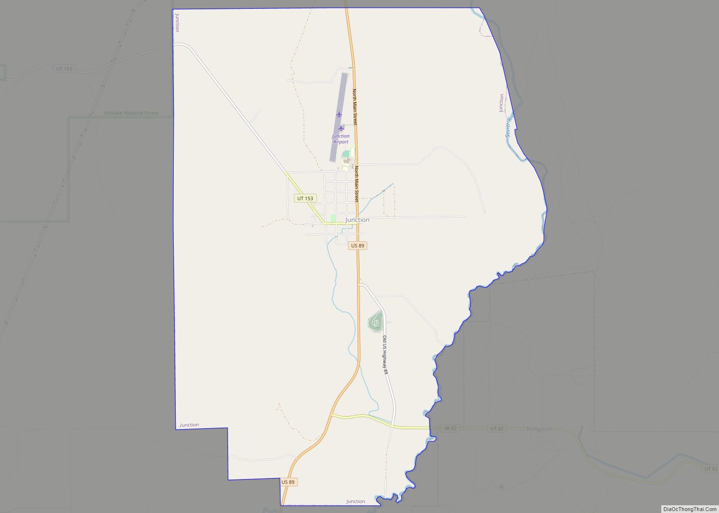
Map of Ferron city

Map of Ferron city

Ferron (/ˈfɛrən/ FERR-ən) is a city in western Emery County, Utah, United States. The population was 1,461 at the 2020 census. Ferron city overview: Name: Ferron city LSAD Code: 25 LSAD Description: city (suffix) State: Utah County: Emery County Elevation: 5,971 ft (1,820 m) Total Area: 2.33 sq mi (6.03 km²) Land Area: 2.33 sq mi (6.03 km²) Water Area: 0.00 sq mi (0.00 km²) Total … Read more

Map of Fayette town, Utah

Map of Fayette town, Utah

Fayette is a town in Sanpete County, Utah, United States. The population was 204 at the 2000 census. Fayette town overview: Name: Fayette town LSAD Code: 43 LSAD Description: town (suffix) State: Utah County: Sanpete County Incorporated: 1948 Elevation: 5,052 ft (1,540 m) Total Area: 0.40 sq mi (1.02 km²) Land Area: 0.40 sq mi (1.02 km²) Water Area: 0.00 sq mi (0.00 km²) Total Population: … Read more

Map of Glenwood town, Utah

Map of Glenwood town, Utah

Glenwood is a town in Sevier County, Utah, United States. The population was 464 at the 2010 census. Glenwood town overview: Name: Glenwood town LSAD Code: 43 LSAD Description: town (suffix) State: Utah County: Sevier County Founded: 1863 Elevation: 5,272 ft (1,607 m) Total Area: 0.52 sq mi (1.35 km²) Land Area: 0.52 sq mi (1.35 km²) Water Area: 0.00 sq mi (0.00 km²) Total Population: … Read more

Map of Glendale town, Utah

Map of Glendale town, Utah

Glendale is a town in Kane County, Utah, United States. The population was 381 at the 2010 census. Glendale town overview: Name: Glendale town LSAD Code: 43 LSAD Description: town (suffix) State: Utah County: Kane County Founded: 1862 Incorporated: March 29, 1935 Elevation: 5,778 ft (1,761 m) Total Area: 7.00 sq mi (18.12 km²) Land Area: 7.00 sq mi (18.12 km²) Water Area: … Read more

Map of Genola town, Utah

Map of Genola town, Utah

Genola (/dʒəˈnoʊlə/ jə-NOH-lə) is a town in Utah County, Utah, United States. It is part of the Provo–Orem Metropolitan Statistical Area. The population was 1,370 at the 2010 census. Genola town overview: Name: Genola town LSAD Code: 43 LSAD Description: town (suffix) State: Utah County: Utah County Incorporated: December 29, 1935 Elevation: 4,600 ft (1,402 m) Total … Read more

Map of Garland city, Utah

Map of Garland city, Utah

Garland is a city in northeastern Box Elder County, Utah, United States. The population was 2,400 at the 2010 census. Garland city overview: Name: Garland city LSAD Code: 25 LSAD Description: city (suffix) State: Utah County: Box Elder County Elevation: 4,340 ft (1,323 m) Total Area: 1.81 sq mi (4.69 km²) Land Area: 1.81 sq mi (4.69 km²) Water Area: 0.00 sq mi (0.00 km²) Total … Read more

Map of Garden CDP, Utah

Map of Garden CDP, Utah

Garden is a census-designated place (CDP) in Rich County, Utah, United States. It includes the southernmost subdivision of Garden City at its northeast and the hamlet of Meadowville at its southeast; otherwise it is farmland. The population was 181 at the 2010 census. Garden CDP overview: Name: Garden CDP LSAD Code: 57 LSAD Description: CDP … Read more

Map of Garden City town, Utah

Map of Garden City town, Utah

Garden City is a town in northwestern Rich County, Utah, United States. The population was 562 at the 2010 census. Garden City sits on the shores of Bear Lake and is a popular summer resort destination town, thus nicknamed the “Caribbean of the Rockies”. Garden City town overview: Name: Garden City town LSAD Code: 43 … Read more

Map of Fruit Heights city

Map of Fruit Heights city

Fruit Heights is a city in eastern Davis County, Utah, United States. It is part of the Ogden–Clearfield, Utah Metropolitan Statistical Area. It lies along the Wasatch Front adjacent to the larger cities of Farmington and Kaysville. Its population was 4,987 at the 2010 census, with an estimated population of 6,234 in 2018. Fruit Heights … Read more

Map of Fremont CDP, Utah

Map of Fremont CDP, Utah

Fremont is a census-designated place in northwestern Wayne County, Utah, United States. It lies along State Route 72 just northeast of the town of Loa, the county seat of Wayne County. To the north is Fishlake National Forest. Fremont’s elevation is 7,218 feet (2,200 m). The population was 145 at the 2010 census. Fremont’s first permanent … Read more

Map of Francis town, Utah

Map of Francis town, Utah

Francis is a town in on the western edge of Summit County, Utah, United States. It is part of the Salt Lake City, Utah Metropolitan Statistical Area. The population was 1,077 at the 2010 census. Francis town overview: Name: Francis town LSAD Code: 43 LSAD Description: town (suffix) State: Utah County: Summit County Incorporated: 1939 … Read more

Map of Fountain Green city

Map of Fountain Green city

Fountain Green is a city in Sanpete County, Utah, United States. The population was 1,071 at the 2010 census. Fountain Green city overview: Name: Fountain Green city LSAD Code: 25 LSAD Description: city (suffix) State: Utah County: Sanpete County Elevation: 5,899 ft (1,798 m) Total Area: 1.25 sq mi (3.24 km²) Land Area: 1.25 sq mi (3.24 km²) Water Area: 0.00 sq mi (0.00 km²) Total … Read more