Map of Salt Lake City city

Map of Salt Lake City

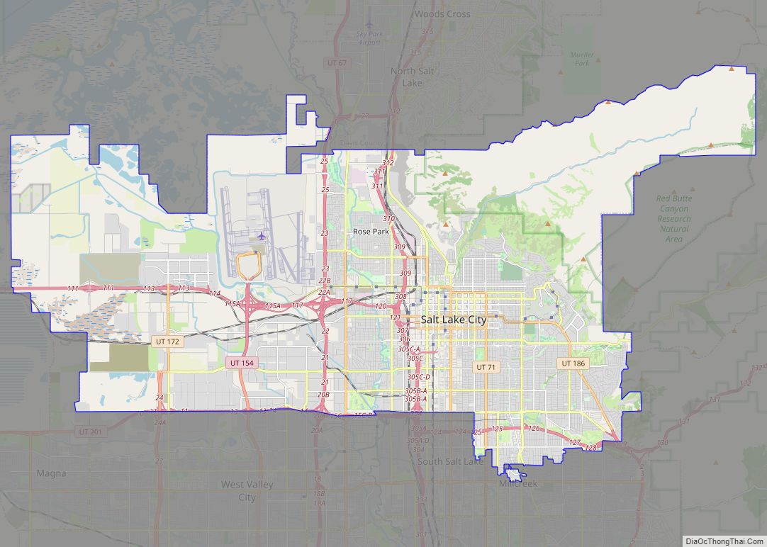
Salt Lake City, often shortened to Salt Lake, and colloquially called SLC, is the capital and most populous city of Utah, United States. It is the seat of Salt Lake County, the most populous county in Utah. With a population of 200,133 in 2020, the city is the core of the Salt Lake City metropolitan … Read more

Map of West Valley City city

Map of West Valley City

West Valley City is a city in Salt Lake County and a suburb of Salt Lake City in the U.S. state of Utah. The population was 140,230 at the 2020 census, making it the second-largest city in Utah. The city incorporated in 1980 from a large, quickly growing unincorporated area, combining the four communities of … Read more

Map of Provo city

Map of Provo city

Provo (/ˈproʊvoʊ/ PROH-voh) is the fourth-largest city in Utah, United States. It is 43 miles (69 km) south of Salt Lake City along the Wasatch Front. Provo is the largest city and county seat of Utah County and lies between the cities of Orem to the north and Springville to the south. With a population at … Read more

Map of Orem city

Map of Orem city

Orem is a city in Utah County, Utah, United States, in the northern part of the state. It is adjacent to Provo, Lindon, and Vineyard and is approximately 45 miles (72 km) south of Salt Lake City. Orem is one of the principal cities of the Provo-Orem, Utah Metropolitan Statistical Area, which includes all of Utah … Read more

Map of Altamont town, Utah

Map of Altamont town, Utah

Altamont is a town in Duchesne County, Utah, United States. The population was 225 at the 2010 census, an increase over the 2000 figure of 178. Altamont town overview: Name: Altamont town LSAD Code: 43 LSAD Description: town (suffix) State: Utah County: Duchesne County Incorporated: 1953 Elevation: 6,388 ft (1,947 m) Total Area: 0.21 sq mi (0.55 km²) Land Area: … Read more

Map of Alta town, Utah

Map of Alta town, Utah

Alta is a town in eastern Salt Lake County, Utah, United States. It is part of the Salt Lake City, Utah Metropolitan Statistical Area. The population was 383 at the 2010 census, a slight increase from the 2000 figure of 370. Alta is centered in the Alta Ski Area, a ski resort that has 500,000 … Read more

Map of Alpine city, Utah

Map of Alpine city, Utah

Alpine is a city on the northeastern edge of Utah County, Utah, United States. The population was 10,251 at the time of the 2020 census. Alpine has been one of the many quickly-growing cities of Utah since the 1970s, especially in the 1990s. This city is thirty-two miles southeast of Salt Lake City. It is … Read more

Map of Apple Valley town, Utah

Map of Apple Valley town, Utah

Apple Valley is a town in Washington County, Utah, United States, located 12 miles (19 km) east of Hurricane along SR-59. The population was 701 at the 2010 census. Apple Valley was incorporated on October 15, 2004, and a 2007 population estimate by the US Census Bureau placed its population at 427. In 2006, some town … Read more

Map of Antimony town

Map of Antimony town

Antimony is a town in Garfield County, Utah, United States. The population was 122 at the 2010 census, the same as the 2000 census. Antimony town overview: Name: Antimony town LSAD Code: 43 LSAD Description: town (suffix) State: Utah County: Garfield County Incorporated: 1934 Elevation: 6,453 ft (1,967 m) Total Area: 9.82 sq mi (25.44 km²) Land Area: 9.82 sq mi (25.44 km²) … Read more

Map of Annabella town

Map of Annabella town

Annabella is a town in Sevier County, Utah, United States. The population was 795 at the 2010 census, an increase over the 2000 figure of 603. Annabella town overview: Name: Annabella town LSAD Code: 43 LSAD Description: town (suffix) State: Utah County: Sevier County Elevation: 5,292 ft (1,613 m) Total Area: 0.65 sq mi (1.69 km²) Land Area: 0.65 sq mi (1.69 km²) … Read more

Map of Aneth CDP

Map of Aneth CDP

Aneth (Navajo: Tʼáá Bííchʼį́įdii) is a census-designated place (CDP) in San Juan County, Utah, United States. The population was 598 at the 2000 census. The origin of the name Aneth is obscure. Aneth CDP overview: Name: Aneth CDP LSAD Code: 57 LSAD Description: CDP (suffix) State: Utah County: San Juan County Elevation: 4,511 ft (1,375 m) Total … Read more