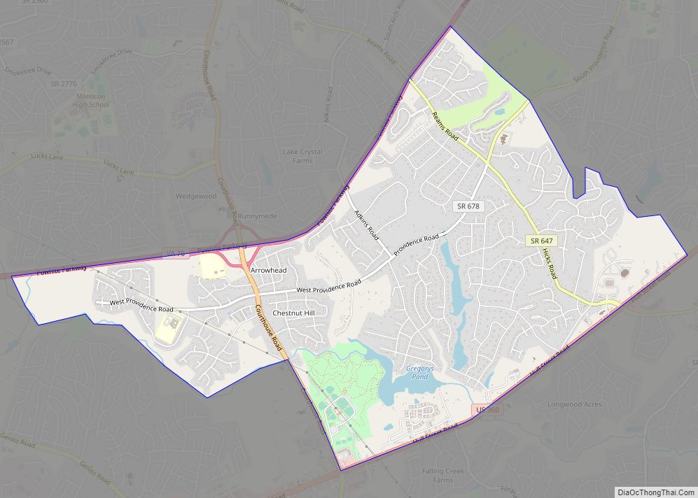
Map of Midland CDP, Virginia

Map of Midland CDP, Virginia

Midland CDP overview: Name: Midland CDP LSAD Code: 57 LSAD Description: CDP (suffix) State: Virginia County: Fauquier County FIPS code: 5151544 Online Interactive Map Midland online map. Source: Basemap layers from Google Map, Open Street Map (OSM), Arcgisonline, Wmflabs. Boundary Data from Database of Global Administrative Areas. Midland location map. Where is Midland CDP? Midland … Read more

Map of Middletown town, Virginia

Map of Middletown town, Virginia

Middletown is a town in Frederick County, Virginia, United States, in the northern Shenandoah Valley. The population was 1,265 at the 2010 census, up from 1,015 at the 2000 census. Middletown town overview: Name: Middletown town LSAD Code: 43 LSAD Description: town (suffix) State: Virginia County: Frederick County Elevation: 715 ft (218 m) Total Area: 0.78 sq mi (2.01 km²) … Read more

Map of Middleburg town, Virginia

Map of Middleburg town, Virginia

Middleburg is a town in Loudoun County, Virginia, United States, with a population of 673 as of the 2010 census. It is the southernmost town along Loudoun County’s shared border with Fauquier County. Middleburg is known as the “Nation’s Horse and Hunt Capital” for its foxhunting, steeplechases, and large estates. The Middleburg Historic District, comprising … Read more

Map of Middlebrook CDP

Map of Middlebrook CDP

Middlebrook is a census-designated place in Augusta County, Virginia. The population as of the 2020 Census was 184. Middlebrook Historic District, Middlebrook Schools, A. J. Miller House, Henry Mish Barn and Maple Front Farm are listed on the National Register of Historic Places. Middlebrook CDP overview: Name: Middlebrook CDP LSAD Code: 57 LSAD Description: CDP … Read more

Map of Metompkin CDP

Map of Metompkin CDP

Metompkin is a census-designated place (CDP) in Accomack County, Virginia, United States. Per the 2020 census, the population was 490. Metompkin CDP overview: Name: Metompkin CDP LSAD Code: 57 LSAD Description: CDP (suffix) State: Virginia County: Accomack County Elevation: 30 ft (9 m) Total Area: 490 FIPS code: 5151362 GNISfeature ID: 2584880 Online Interactive Map Metompkin online … Read more

Map of Merrimac CDP

Map of Merrimac CDP, Virginia

Merrimac is a census-designated place (CDP) in Montgomery County, Virginia, United States. The population was 2,133 at the 2010 census. It is part of the Blacksburg–Christiansburg Metropolitan Statistical Area which encompasses all of Montgomery County and the city of Radford. Merrimac CDP overview: Name: Merrimac CDP LSAD Code: 57 LSAD Description: CDP (suffix) State: Virginia … Read more

Map of Montrose CDP, Virginia

Map of Montrose CDP, Virginia

Montrose is a census-designated place (CDP) in Henrico County, Virginia, United States. The population was 7,909 at the 2020 census. Montrose CDP overview: Name: Montrose CDP LSAD Code: 57 LSAD Description: CDP (suffix) State: Virginia County: Henrico County Elevation: 161 ft (49 m) Total Area: 3.3 sq mi (8.5 km²) Land Area: 3.2 sq mi (8.3 km²) Water Area: 0.08 sq mi (0.2 km²) Total Population: … Read more

Map of Mount Vernon CDP, Virginia

Map of Mount Vernon CDP, Virginia

Mount Vernon is a census-designated place (CDP) and unincorporated community in Fairfax County, Virginia, United States. The population was 12,416 at the 2010 census. Primarily due to its historical significance and natural recreation and beauty, the Mount Vernon area receives over one million tourists each year. While the name “Mount Vernon”—drawn from the Mount Vernon … Read more

Map of Mount Sidney CDP

Map of Mount Sidney CDP

Mount Sidney is a census-designated place in Augusta County, Virginia. The population as of the 2010 Census was 663. The Mt. Sidney Historic District and Mt. Sidney School are listed on the National Register of Historic Places. Mount Sidney CDP overview: Name: Mount Sidney CDP LSAD Code: 57 LSAD Description: CDP (suffix) State: Virginia County: … Read more

Map of Mount Jackson town

Map of Mount Jackson town

Mount Jackson is a town in Shenandoah County, Virginia, United States. The population was 1,994 at the 2010 census. For highway travelers passing by, Mount Jackson is easily identified from I-81 exit 273 by the water tower painted as a basket of apples, which was recently repainted. For those exploring off the highway, the town … Read more

Map of Mount Hermon CDP, Virginia

Map of Mount Hermon CDP, Virginia

Mount Hermon is a census-designated place (CDP) in Pittsylvania County, Virginia, United States. The population as of the 2010 Census was 3,966. Mount Hermon is located approximately 3 miles northwest of the city limits of Danville, Virginia. Mount Hermon CDP overview: Name: Mount Hermon CDP LSAD Code: 57 LSAD Description: CDP (suffix) State: Virginia County: … Read more

Map of Mount Crawford town

Map of Mount Crawford town

Mount Crawford is a town in Rockingham County, Virginia, United States. It is included in the Harrisonburg Metropolitan Statistical Area, and the town’s population was 433 at the 2010 census. Mount Crawford town overview: Name: Mount Crawford town LSAD Code: 43 LSAD Description: town (suffix) State: Virginia County: Rockingham County Elevation: 1,204 ft (367 m) Total Area: … Read more