Map of Accomac town

Map of Accomac town

Accomac is a town in and the county seat of Accomack County, Virginia, United States. The population was 526 at the 2020 census. Accomac town overview: Name: Accomac town LSAD Code: 43 LSAD Description: town (suffix) State: Virginia County: Accomack County Elevation: 39 ft (12 m) Total Area: 0.41 sq mi (1.06 km²) Land Area: 0.41 sq mi (1.06 km²) Water Area: 0.00 sq mi … Read more

Map of Abingdon town, Virginia

Map of Abingdon town, Virginia

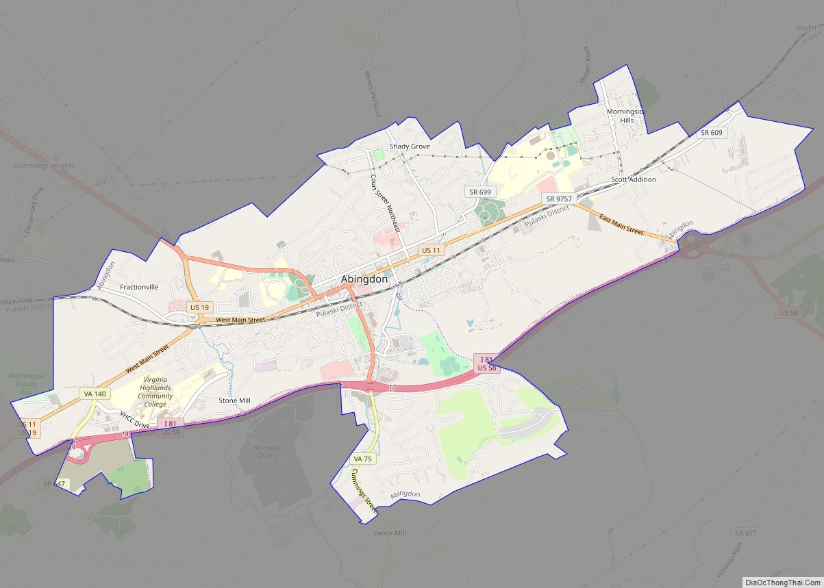
Abingdon is a town in Washington County, Virginia, United States, 133 miles (214 km) southwest of Roanoke. The population was 8,376 at the 2020 census. It is the county seat of Washington County. The town encompasses several historically significant sites and features a fine arts and crafts scene centered on the galleries and museums along Main … Read more

Map of Appomattox town

Map of Appomattox town

Appomattox is a town in Appomattox County, Virginia, United States. The population was 1,733 at the 2010 census. It is the county seat of Appomattox County. Appomattox is part of the Lynchburg Metropolitan Statistical Area. Appomattox town overview: Name: Appomattox town LSAD Code: 43 LSAD Description: town (suffix) State: Virginia County: Appomattox County Elevation: 850 ft … Read more

Map of Apple Mountain Lake CDP

Map of Apple Mountain Lake CDP

Apple Mountain Lake is a census-designated place in Warren County, Virginia. The population as of the 2010 Census was 1,396. Apple Mountain Lake CDP overview: Name: Apple Mountain Lake CDP LSAD Code: 57 LSAD Description: CDP (suffix) State: Virginia County: Warren County ZIP code: 22642 FIPS code: 5102064 GNISfeature ID: 2629747 Online Interactive Map Apple … Read more

Map of Appalachia town

Map of Appalachia town

Appalachia is a town in Wise County, Virginia, United States. The population was 1,754 at the 2010 census. Appalachia town overview: Name: Appalachia town LSAD Code: 43 LSAD Description: town (suffix) State: Virginia County: Wise County Elevation: 1,647 ft (502 m) Total Area: 2.31 sq mi (5.97 km²) Land Area: 2.28 sq mi (5.92 km²) Water Area: 0.02 sq mi (0.06 km²) Total Population: 1,754 Population … Read more

Map of Annandale CDP, Virginia

Map of Annandale CDP, Virginia

Annandale (/ˈænəndeɪl/) is a census-designated place (CDP) in Fairfax County, Virginia. The population of the CDP was 43,363 as of the 2020 United States Census. It is home to the oldest and largest branch of the Northern Virginia Community College system, and to one of the D.C. area’s Koreatowns. Annandale CDP overview: Name: Annandale CDP … Read more

Map of Amherst town, Virginia

Map of Amherst town, Virginia

Amherst (formerly Dearborn) is a town in Amherst County, Virginia, United States. The population was 2,231 at the 2010 census. It is the county seat of Amherst County. Amherst is part of the Lynchburg Metropolitan Statistical Area. Amherst town overview: Name: Amherst town LSAD Code: 43 LSAD Description: town (suffix) State: Virginia County: Amherst County … Read more

Map of Amelia Court House CDP

Map of Amelia Court House CDP

Amelia Court House (also known as Amelia Courthouse and Amelia) is the county seat of Amelia County in the U.S. state of Virginia and a census-designated place (CDP). The population as of the 2010 census was 1,099. The town was named for Princess Amelia of Great Britain, the second daughter of Great Britain’s King George … Read more

Map of Altavista town

Map of Altavista town

Altavista is an incorporated town in Campbell County, Virginia, United States. The population was 3,450 at the 2010 census. It is part of the Lynchburg Metropolitan Statistical Area. Altavista town overview: Name: Altavista town LSAD Code: 43 LSAD Description: town (suffix) State: Virginia County: Campbell County Elevation: 548 ft (167 m) Total Area: 5.24 sq mi (13.58 km²) Land Area: … Read more

Map of Allisonia CDP

Map of Allisonia CDP

Allisonia is a census-designated place (CDP) in Pulaski County, Virginia, United States. The population as of the 2010 Census was 117. Allisonia CDP overview: Name: Allisonia CDP LSAD Code: 57 LSAD Description: CDP (suffix) State: Virginia County: Pulaski County FIPS code: 5101256 Online Interactive Map Allisonia online map. Source: Basemap layers from Google Map, Open … Read more

Map of Alberta town, Virginia

Map of Alberta town, Virginia

Alberta is a town in Brunswick County, Virginia, United States. The population was 298 at the 2010 census. It is home to the Christanna Campus of Southside Virginia Community College. Alberta town overview: Name: Alberta town LSAD Code: 43 LSAD Description: town (suffix) State: Virginia County: Brunswick County Elevation: 397 ft (121 m) Total Area: 2.15 sq mi (5.56 km²) … Read more

Map of Adwolf CDP

Map of Adwolf CDP

Adwolf CDP overview: Name: Adwolf CDP LSAD Code: 57 LSAD Description: CDP (suffix) State: Virginia County: Smyth County FIPS code: 5100468 Online Interactive Map Adwolf online map. Source: Basemap layers from Google Map, Open Street Map (OSM), Arcgisonline, Wmflabs. Boundary Data from Database of Global Administrative Areas. Adwolf location map. Where is Adwolf CDP? Adwolf … Read more