Map of Lake Holm CDP
Lake Holm is a census-designated place (CDP) in King County, Washington, United States. The population was 3,221 at the 2010 census. Lake Holm CDP overview: Name: Lake Holm CDP LSAD Code: 57 LSAD Description: CDP (suffix) State: Washington County: King County Elevation: 400 ft (100 m) Total Area: 8.56 sq mi (22.18 km²) Land Area: 8.36 sq mi (21.65 km²) Water Area: 0.20 sq mi ... Read more
Map of Lake Holm CDP
Map of Lake Goodwin CDP
Lake Goodwin is a former census-designated place (CDP) in Snohomish County, Washington, United States. The population was 3,354 at the 2000 census. The CDP was discontinued at the 2010 census. Based on per capita income, one of the more reliable measures of affluence, Lake Goodwin ranks 58th of 522 areas in the state of Washington ... Read more
Map of Lake Goodwin CDP
Map of Lake Forest Park city
Lake Forest Park is a suburban city in King County, Washington, United States, located northeast of Seattle. It was developed in the 20th century as a bedroom community with single-family housing on medium to large-sized lots. Less than 4% of the city’s land is zoned commercial, largely concentrated in one location, and there are no ... Read more
Map of Lake Forest Park city
Map of Lake Cavanaugh CDP
Lake Cavanaugh is a census-designated place (CDP) in Skagit County, Washington, United States. The population was 167 at the 2010 census. It is included in the Mount Vernon–Anacortes, Washington Metropolitan Statistical Area. Based on per capita income, Lake Cavanaugh ranks 30th of 522 areas in the state of Washington to be ranked. It is also ... Read more
Map of Lake Cavanaugh CDP
Map of Lake Shore CDP, Washington
Lake Shore is a census-designated place (CDP) in Clark County, Washington, United States. The population was 6,571 at the 2010 census. Based on per capita income, one of the more reliable measures of affluence, Lake Shore ranks 124th of 614 areas in the state of Washington to be ranked. Lake Shore CDP overview: Name: Lake ... Read more
Map of Lake Shore CDP, Washington
Map of Lake Roesiger CDP
Lake Roesiger is a census-designated place (CDP) in Snohomish County, Washington, United States. The population was 503 at the 2010 census. Based on per capita income, one of the more reliable measures of affluence, Lake Roesiger ranks 98th of 522 areas in the state of Washington to be ranked. Lake Roesiger CDP overview: Name: Lake ... Read more
Map of Lake Roesiger CDP
Map of Lake Morton-Berrydale CDP
Lake Morton-Berrydale is a census-designated place (CDP) in King County, Washington, United States. The population was 10,474 at the 2020 census. Based on per capita income, one of the more reliable measures of affluence, Lake Morton-Berrydale ranks 44th of 522 areas in the state of Washington to be ranked. Lake Morton-Berrydale CDP overview: Name: Lake ... Read more
Map of Lake Morton-Berrydale CDP
Map of Lake McMurray CDP
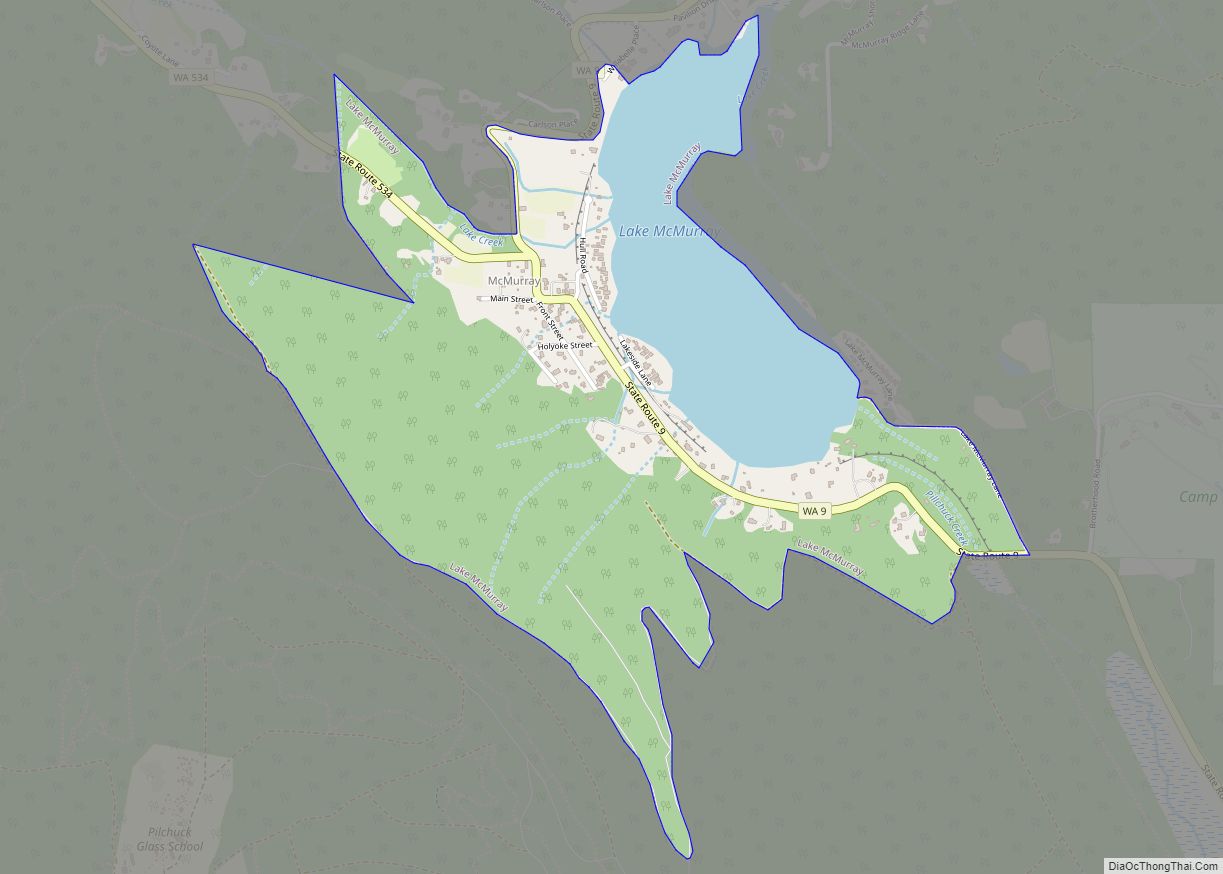
Lake McMurray is a census-designated place (CDP) in Skagit County, Washington, United States. The population was 192 at the 2010 census. It is included in the Mount Vernon–Anacortes, Washington Metropolitan Statistical Area. Based on per capita income, Lake McMurray ranks 43rd of 522 ranked areas in the state of Washington. It is part of the ... Read more
Map of Lake McMurray CDP
Map of Lake Marcel-Stillwater CDP
Lake Marcel-Stillwater is a census-designated place (CDP) in King County, Washington, United States. The population was 1,277 at the 2010 census. Lake Marcel-Stillwater CDP overview: Name: Lake Marcel-Stillwater CDP LSAD Code: 57 LSAD Description: CDP (suffix) State: Washington County: King County Elevation: 300 ft (90 m) Total Area: 1.33 sq mi (3.45 km²) Land Area: 1.27 sq mi (3.30 km²) Water Area: 0.06 sq mi ... Read more
Map of Lake Marcel-Stillwater CDP
Map of Larch Way CDP
Larch Way is a census-designated place (CDP) located in Snohomish County, Washington. Larch Way CDP overview: Name: Larch Way CDP LSAD Code: 57 LSAD Description: CDP (suffix) State: Washington County: Snohomish County Elevation: 505 ft (154 m) Total Area: 1.11 sq mi (2.9 km²) Total Population: 3,318 Population Density: 3,000/sq mi (1,100/km²) Area code: 360 FIPS code: 5338420 Online Interactive Map ... Read more
Map of Larch Way CDP
Map of Langley city, Washington
Langley is a city in Island County, Washington, United States. It sits near the south end of Whidbey Island, overlooking the Saratoga Passage. It is the third largest incorporated area on Whidbey. The population was 1,035 at the 2010 census, while the ZCTA for Langley’s post office had a population of 4,878. The geographical area ... Read more
Map of Langley city, Washington
Map of Lamont town, Washington
Lamont town overview: Name: Lamont town LSAD Code: 43 LSAD Description: town (suffix) State: Washington County: Whitman County FIPS code: 5338215 Online Interactive Map Lamont online map. Source: Basemap layers from Google Map, Open Street Map (OSM), Arcgisonline, Wmflabs. Boundary Data from Database of Global Administrative Areas. Lamont location map. Where is Lamont town? Lamont ... Read more
Map of Lamont town, Washington