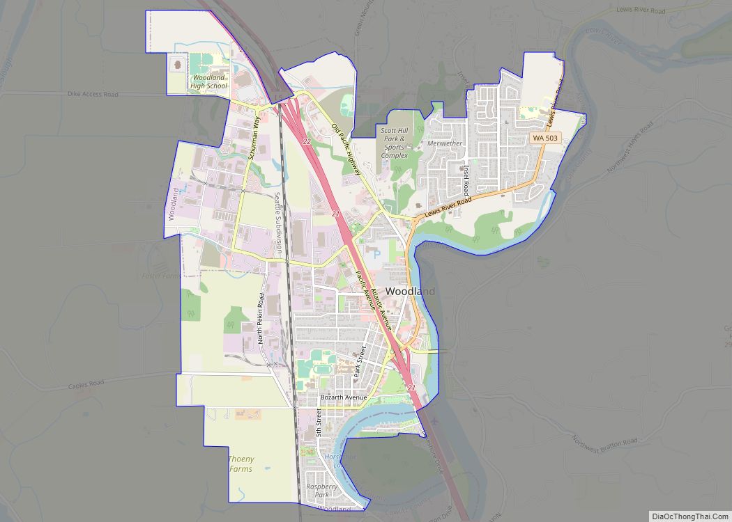
Map of Oyehut CDP

Map of Oyehut CDP

Oyehut is a census-designated place (CDP) in Grays Harbor County, Washington, United States. The population was 85 at the 2010 census. Prior to 2010 it was part of the combined Oyehut-Hogan’s Corner CDP. Oyehut CDP overview: Name: Oyehut CDP LSAD Code: 57 LSAD Description: CDP (suffix) State: Washington County: Grays Harbor County Elevation: 15 ft (5 m) … Read more

Map of Pomeroy city, Washington

Map of Pomeroy city, Washington

Pomeroy is a city in Garfield County, Washington, United States. The population was 1,425 at the 2010 census. It is the county seat of and only incorporated city in Garfield County. Pomeroy city overview: Name: Pomeroy city LSAD Code: 25 LSAD Description: city (suffix) State: Washington County: Garfield County Elevation: 1,857 ft (566 m) Total Area: 1.78 sq mi … Read more

Map of Outlook CDP, Washington

Map of Outlook CDP, Washington

Outlook is a census-designated place and unincorporated community in Yakima County, Washington, United States. Outlook is located along Interstate 82 and U.S. Route 12 4 miles (6.4 km) west of Sunnyside. Outlook has a post office with ZIP code 98938. Outlook CDP overview: Name: Outlook CDP LSAD Code: 57 LSAD Description: CDP (suffix) State: Washington County: … Read more

Map of Point Roberts CDP

Map of Point Roberts CDP

Point Roberts is a pene-exclave of Washington on the southernmost tip of the Tsawwassen peninsula, south of Vancouver, British Columbia. The area, which had a population of 1,191 at the 2020 census, is reached by land from the rest of the United States by traveling 25 mi (40 km) through Canada. It is a census-designated place in … Read more

Map of Otis Orchards-East Farms CDP

Map of Otis Orchards-East Farms CDP

Otis Orchards-East Farms is a census-designated place (CDP) in Spokane County, Washington, United States, near the county’s border with Idaho. The population was 6,299 at the 2020 census. The CDP includes the unincorporated communities of Otis Orchards and East Farms. Otis Orchards contains the bulk of the businesses of the community. Otis Orchards-East Farms is … Read more

Map of Pine Grove CDP, Washington

Map of Pine Grove CDP, Washington

Pine Grove is a census-designated place located in Ferry County, Washington, United States. Pine Grove CDP overview: Name: Pine Grove CDP LSAD Code: 57 LSAD Description: CDP (suffix) State: Washington County: Ferry County Elevation: 2,579 ft (786 m) Total Area: 0.49 sq mi (1.27 km²) Land Area: 0.49 sq mi (1.27 km²) Water Area: 0.0 sq mi (0.0 km²) Total Population: 145 Population Density: 300/sq mi (110/km²) … Read more

Map of Picnic Point CDP

Map of Picnic Point CDP

Picnic Point is a census-designated place (CDP) located in Snohomish County, Washington. The population was 8,809 at the 2010 census. It was formerly part of the Picnic Point-North Lynnwood CDP. Picnic Point CDP overview: Name: Picnic Point CDP LSAD Code: 57 LSAD Description: CDP (suffix) State: Washington County: Snohomish County Elevation: 79 ft (24 m) Total Area: … Read more

Map of Peaceful Valley CDP

Map of Peaceful Valley CDP

Peaceful Valley is a census-designated place (CDP) in Whatcom County, Washington, United States, near Kendall. The population was 3,324 at the 2010 census. Peaceful Valley CDP overview: Name: Peaceful Valley CDP LSAD Code: 57 LSAD Description: CDP (suffix) State: Washington County: Whatcom County Total Area: 17.0 sq mi (44.0 km²) Land Area: 16.9 sq mi (43.9 km²) Water Area: 0.0 sq mi (0.1 km²) … Read more

Map of Pe Ell town

Map of Pe Ell town

Pe Ell town overview: Name: Pe Ell town LSAD Code: 43 LSAD Description: town (suffix) State: Washington County: Lewis County FIPS code: 5353930 Online Interactive Map Pe Ell online map. Source: Basemap layers from Google Map, Open Street Map (OSM), Arcgisonline, Wmflabs. Boundary Data from Database of Global Administrative Areas. Pe Ell location map. Where … Read more

Map of Pateros city

Map of Pateros city

Pateros /pəˈtærəs/ pə-TARR-əs is a city in Okanogan County, Washington, United States. The population was 643 at the 2000 census and increased 3.7% to 667 in the 2010 census. Pateros city overview: Name: Pateros city LSAD Code: 25 LSAD Description: city (suffix) State: Washington County: Okanogan County Founded: c. 1886 Incorporated: May 1, 1913 Elevation: 804 ft … Read more

Map of Pasco city

Map of Pasco city

Pasco (/ˈpæskoʊ/ PAS-koh) is a city in, and the county seat of, Franklin County, Washington, United States. It had a population of 59,781 at the 2010 census, and 75,432 as of the July 1, 2019 Census Bureau estimate. Pasco is one of three cities (the others being Kennewick and Richland) that make up Washington state’s … Read more

Map of Parkwood CDP, Washington

Map of Parkwood CDP, Washington

Parkwood is a census-designated place (CDP) in Kitsap County, Washington, United States. The population was 7,126 at the 2010 census. Parkwood CDP overview: Name: Parkwood CDP LSAD Code: 57 LSAD Description: CDP (suffix) State: Washington County: Kitsap County Elevation: 266 ft (81 m) Total Area: 2.7 sq mi (6.9 km²) Land Area: 2.6 sq mi (6.8 km²) Water Area: 0.0 sq mi (0.1 km²) Total Population: … Read more