Map of Wilson Creek town
Wilson Creek town overview: Name: Wilson Creek town LSAD Code: 43 LSAD Description: town (suffix) State: Washington County: Grant County FIPS code: 5379135 Online Interactive Map Wilson Creek online map. Source: Basemap layers from Google Map, Open Street Map (OSM), Arcgisonline, Wmflabs. Boundary Data from Database of Global Administrative Areas. Wilson Creek location map. Where ... Read more
Map of Wilson Creek town
Map of Willapa CDP
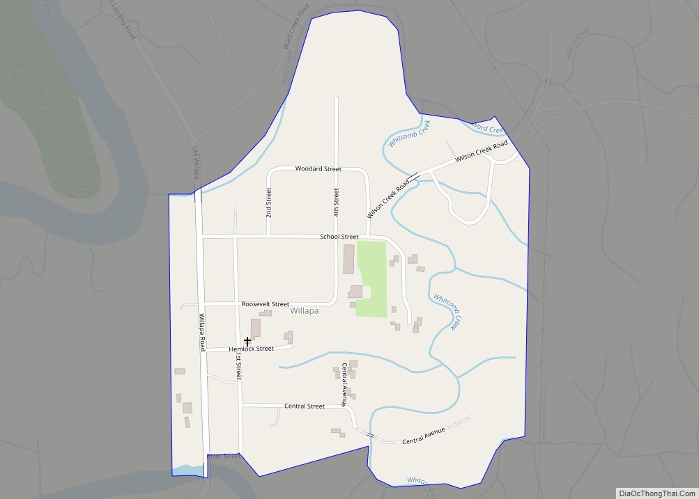
Willapa is a census-designated place (CDP) in Pacific County, Washington, east of the city of Raymond. The population was 210 as of the 2010 census. The name comes from that of the Willapa people, an Athapaskan-speaking people, now extinct, who occupied the Willapa River valley, which was similarly named after the Willapa people, along which ... Read more
Map of Willapa CDP
Map of Wilkeson town
Wilkeson town overview: Name: Wilkeson town LSAD Code: 43 LSAD Description: town (suffix) State: Washington County: Pierce County FIPS code: 5378925 Online Interactive Map Wilkeson online map. Source: Basemap layers from Google Map, Open Street Map (OSM), Arcgisonline, Wmflabs. Boundary Data from Database of Global Administrative Areas. Wilkeson location map. Where is Wilkeson town? Wilkeson ... Read more
Map of Wilkeson town
Map of Wilderness Rim CDP
Wilderness Rim is a census-designated place (CDP) in King County, Washington, United States. It lies at an elevation of 1,043 feet (318 m). The population was 1,523 at the 2010 census. Wilderness Rim CDP overview: Name: Wilderness Rim CDP LSAD Code: 57 LSAD Description: CDP (suffix) State: Washington County: King County Elevation: 1,043 ft (318 m) Total Area: ... Read more
Map of Wilderness Rim CDP
Map of Zillah city
Zillah is a city in Yakima County, Washington, United States, with a population of 3,179 as of the 2020 census. Zillah city overview: Name: Zillah city LSAD Code: 25 LSAD Description: city (suffix) State: Washington County: Yakima County Founded: 1892 Incorporated: January 5, 1911 Elevation: 820 ft (250 m) Total Area: 1.82 sq mi (4.72 km²) Land Area: 1.82 sq mi (4.72 km²) ... Read more
Map of Zillah city
Map of Wilbur town
Wilbur town overview: Name: Wilbur town LSAD Code: 43 LSAD Description: town (suffix) State: Washington County: Lincoln County FIPS code: 5378680 Online Interactive Map Wilbur online map. Source: Basemap layers from Google Map, Open Street Map (OSM), Arcgisonline, Wmflabs. Boundary Data from Database of Global Administrative Areas. Wilbur location map. Where is Wilbur town? Wilbur ... Read more
Map of Wilbur town
Map of Yelm city
Yelm (/jɛlm/) is a city in Thurston County, Washington, United States. Its population was 10,617 at the 2020 census. At the beginning of the 21st century, Yelm was the 10th fastest growing city in the state in regard to population. Yelm city overview: Name: Yelm city LSAD Code: 25 LSAD Description: city (suffix) State: Washington ... Read more
Map of Yelm city
Map of White Swan CDP
White Swan is a census-designated place (CDP) in Yakima County, Washington, United States. The population was 3,033 at the 2000 census. White Swan CDP overview: Name: White Swan CDP LSAD Code: 57 LSAD Description: CDP (suffix) State: Washington County: Yakima County Elevation: 968 ft (295 m) Total Area: 103.3 sq mi (267.6 km²) Land Area: 103.3 sq mi (267.6 km²) Water Area: 0.0 sq mi ... Read more
Map of White Swan CDP
Map of Yarrow Point town
Yarrow Point town overview: Name: Yarrow Point town LSAD Code: 43 LSAD Description: town (suffix) State: Washington County: King County FIPS code: 5380150 Online Interactive Map Yarrow Point online map. Source: Basemap layers from Google Map, Open Street Map (OSM), Arcgisonline, Wmflabs. Boundary Data from Database of Global Administrative Areas. Yarrow Point location map. Where ... Read more
Map of Yarrow Point town
Map of Yacolt town
Yacolt town overview: Name: Yacolt town LSAD Code: 43 LSAD Description: town (suffix) State: Washington County: Clark County FIPS code: 5379975 Online Interactive Map Yacolt online map. Source: Basemap layers from Google Map, Open Street Map (OSM), Arcgisonline, Wmflabs. Boundary Data from Database of Global Administrative Areas. Yacolt location map. Where is Yacolt town? Yacolt ... Read more
Map of Yacolt town
Map of Woodway city, Washington
Woodway is a city in Snohomish County, Washington, United States. The population was 1,307 at the 2010 census. Based on per capita income, one of the more reliable measures of affluence, Woodway ranks 6th of 522 areas in the state of Washington to be ranked. It is also the highest rank achieved in Snohomish County. ... Read more
Map of Woodway city, Washington
Map of Woods Creek CDP
Woods Creek is a census-designated place (CDP) in Snohomish County, Washington, United States. The population was 5,589 at the 2010 census. Based on per capita income, one of the more reliable measures of affluence, Woods Creek ranks 80th of 522 areas in the state of Washington to be ranked. Woods Creek CDP overview: Name: Woods ... Read more
Map of Woods Creek CDP