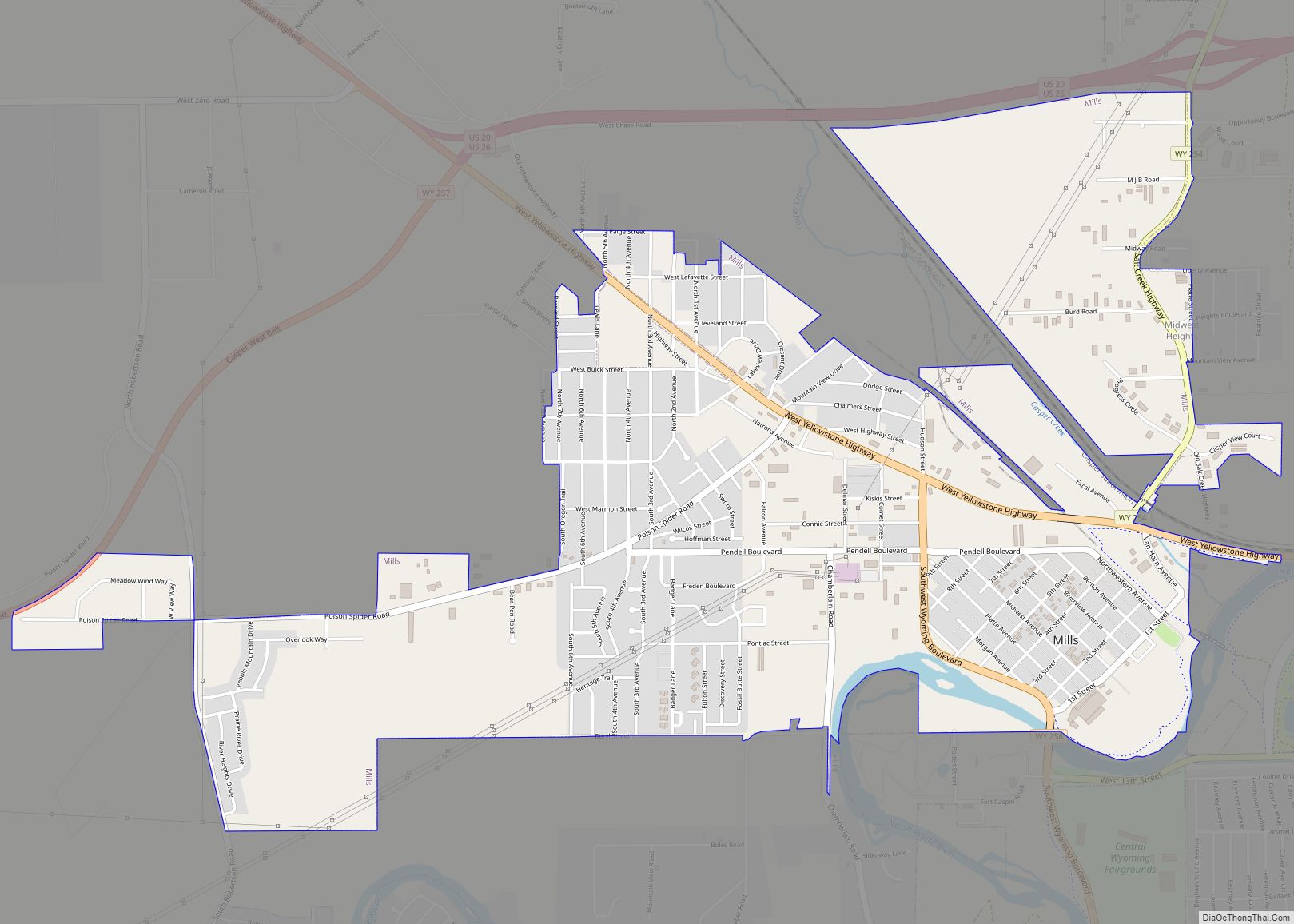
Map of Woods Landing-Jelm CDP

Map of Woods Landing-Jelm CDP

Woods Landing-Jelm is a census-designated place (CDP) in Albany County, Wyoming, United States. The population was 97 at the 2010 census. Woods Landing-Jelm CDP overview: Name: Woods Landing-Jelm CDP LSAD Code: 57 LSAD Description: CDP (suffix) State: Wyoming County: Albany County Total Area: 16.7 sq mi (43 km²) Land Area: 16.7 sq mi (43 km²) Water Area: 0.0 sq mi (0 km²) Total Population: … Read more

Map of Thayne town

Map of Thayne town

Thayne is a town in Lincoln County, Wyoming, United States. The population was 366 at the 2010 census. Thayne town overview: Name: Thayne town LSAD Code: 43 LSAD Description: town (suffix) State: Wyoming County: Lincoln County Elevation: 5,906 ft (1,800 m) Total Area: 1.48 sq mi (3.84 km²) Land Area: 1.48 sq mi (3.84 km²) Water Area: 0.00 sq mi (0.00 km²) Total Population: 366 Population … Read more

Map of Wilson CDP, Wyoming

Map of Wilson CDP, Wyoming

Wilson is a census-designated place (CDP) in Teton County, Wyoming, United States. The population was 1,567 at the 2020 census, up from 1,482 in 2010. It is part of the Jackson, WY–ID Micropolitan Statistical Area. Wilson was pioneered in 1889 by Elijah Nicholas Wilson, known for having lived with the Shoshone Indians as a boy … Read more

Map of Teton Village CDP

Map of Teton Village CDP

Teton Village is a census-designated place (CDP) in Teton County, Wyoming, United States. The population was 330 at the 2010 census. The village surrounds the base of the Jackson Hole Mountain Resort. It is accessed from nearby Jackson and the surrounding area via the Moose-Wilson Road (Wyoming highway 390). Teton Village is part of the … Read more

Map of Whiting CDP, Wyoming

Map of Whiting CDP, Wyoming

Whiting is a census-designated place in Platte County, Wyoming, United States. The population was 83 at the 2010 census. Whiting CDP overview: Name: Whiting CDP LSAD Code: 57 LSAD Description: CDP (suffix) State: Wyoming County: Platte County FIPS code: 5683100 Online Interactive Map Whiting online map. Source: Basemap layers from Google Map, Open Street Map … Read more

Map of Wheatland town, Wyoming

Map of Wheatland town, Wyoming

Wheatland is a town in and the county seat of Platte County in southeastern Wyoming, United States. The population was 3,627 at the 2010 census. Wheatland town overview: Name: Wheatland town LSAD Code: 43 LSAD Description: town (suffix) State: Wyoming County: Platte County Elevation: 4,751 ft (1,448 m) Total Area: 4.10 sq mi (10.61 km²) Land Area: 4.10 sq mi (10.61 km²) Water … Read more

Map of Westview Circle CDP

Map of Westview Circle CDP

Westview Circle is a census-designated place (CDP) in Platte County, Wyoming, United States. The population was 52 at the 2010 census. Westview Circle CDP overview: Name: Westview Circle CDP LSAD Code: 57 LSAD Description: CDP (suffix) State: Wyoming County: Platte County Elevation: 4,731 ft (1,442 m) Total Area: 2.3 sq mi (6.0 km²) Land Area: 2.3 sq mi (5.9 km²) Water Area: 0.0 sq mi … Read more

Map of Washam CDP

Map of Washam CDP

Washam is a census-designated place (CDP) in Sweetwater County, Wyoming, United States. The population was 51 at the 2010 census. Washam CDP overview: Name: Washam CDP LSAD Code: 57 LSAD Description: CDP (suffix) State: Wyoming County: Sweetwater County Elevation: 6,861 ft (2,091 m) Total Area: 3.1 sq mi (8 km²) Land Area: 3.1 sq mi (8 km²) Water Area: 0.0 sq mi (0 km²) Total Population: … Read more

Map of Warren AFB CDP

Map of Warren AFB CDP

Francis E. Warren Air Force Base (ICAO: KFEW, FAA LID: FEW), shortened as F.E. Warren AFB is a United States Air Force base (AFB) located approximately 3 miles (4.8 km) west of Cheyenne, Wyoming. It is one of three strategic-missile bases in the U.S. It was named in honor of Francis E. Warren in 1930. Warren … Read more

Map of Y-O Ranch CDP

Map of Y-O Ranch CDP

Y-O Ranch is a census-designated place (CDP) in Platte County, Wyoming, United States. The population was 195 at the 2010 census. Y-O Ranch CDP overview: Name: Y-O Ranch CDP LSAD Code: 57 LSAD Description: CDP (suffix) State: Wyoming County: Platte County Elevation: 4,885 ft (1,489 m) Total Area: 2.4 sq mi (6.3 km²) Land Area: 2.4 sq mi (6.3 km²) Water Area: 0.0 sq mi … Read more