Batangas, officially the Province of Batangas (Tagalog: Lalawigan ng Batangas IPA: [bɐˈtaŋgas]), is a first class province of the Philippines located in the southwestern part of Luzon in the Calabarzon region. Its capital is the city of Batangas, and is bordered by the provinces of Cavite and Laguna to the north, and Quezon to the east. Across the Verde Island Passages to the south is the island of Mindoro and to the west lies the South China Sea. Poetically, Batangas is often referred to by its ancient name, Kumintáng.
The province of Batangas was billed as the second richest province in the Philippines by the Commission on Audit by the year 2020. It has been the second richest province in the country for two consecutive years. In 2020, its provincial government posted a record high of ₱25.2 billion worth of assets, the largest in Calabarzon and the whole Luzon.
Batangas is one of the most popular tourist destinations near Metro Manila. It is home to the well-known Taal Volcano, one of the Decade Volcanoes, and the small nearby town of Taal which keeps ancestral houses, churches, and other architecture dating back to the 19th century. The province also has numerous beaches and diving spots including Anilao in Mabini, Sombrero Island in Tingloy, Ligpo Island and Sampaguita Beach in Bauan, Matabungkay in Lian, Punta Fuego in Nasugbu, the municipality of Calatagan, and Laiya in San Juan. All of the marine waters of the province are part of the Verde Island Passage, the center of the world’s marine biodiversity.
Batangas City has the second largest international seaport in the Philippines after Metro Manila. The identification of the city as an industrial growth center in the region and being the focal point of the Calabarzon program is seen in the increasing number of business establishments in the city’s Central Business District (CBD) as well as numerous industries operating in the province’s industrial parks. Lipa City has passed Batangas City as the most populous city in the province.
| Type: | Province |
|---|---|
| Capital: | Batangas City |
| Area: | 3,119.75 km (1,204.54 sq mi) |
| Area Rank: | 44th out of 81 |
| Population: | 2,908,494 |
| Population Rank: | 7th out of 81 |
| Density: | 2.67% |
| ZIP code: | 4200–4234 |
| ISO 3166 code: | PH-BTG |
| Website: | www.batangas.gov.ph |
Online Interactive Map
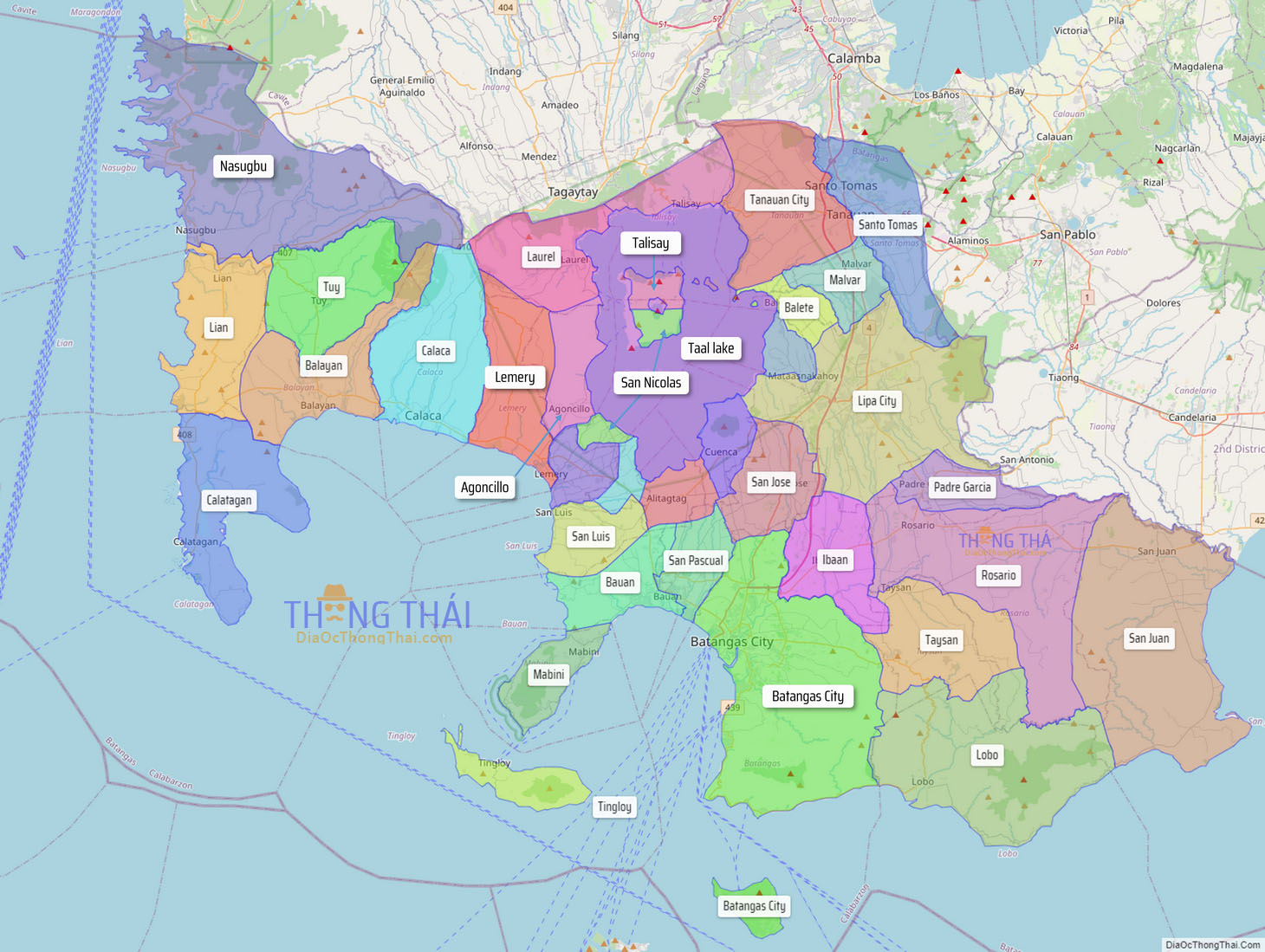
Explore the interactive online map of Batangas, which highlights the administrative boundaries with each sub-administrative unit distinctly colored for easy identification. Just click on the map, and the name of the sub-unit will display, providing an intuitive and engaging way to navigate the area. Users can also view the map in full screen and switch between different map views, including OpenStreetMap, Google Maps, and satellite imagery.
Click on ![]() to view map in "full screen" mode.
to view map in "full screen" mode.
Batangas Political Map
Map of Batangas Province, Philippines the administrative divisions, provincial boundaries, along with detailed depictions of streets, roads, rivers, landmarks, and other geographical features.


