Map of Tazlina CDP

Map of Tazlina CDP

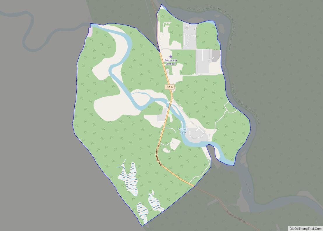
Tazlina /tæzˈliːnə/ (Tezdlen Na’ in Ahtna Athabascan) is a census-designated place (CDP) in the Copper River Census Area, Alaska, United States. At the 2020 census the population was 244, down from 297 in 2010. Tazlina CDP overview: Name: Tazlina CDP LSAD Code: 57 LSAD Description: CDP (suffix) State: Alaska County: Valdez-Cordova Census Area Elevation: 2,418 ft … Read more

Map of Tatitlek CDP

Map of Tatitlek CDP

Tatitlek /təˈtɪtlɪk/ (Alutiiq: Taatiilaaq; Russian: Татитлек) is a census-designated place (CDP) in Chugach Census Area, United States. The population was 88 at the 2010 census, down from 107 in 2000. Tatitlek is in the Chugach School District and has one school, Tatitlek Community School, serving about 15 students from preschool through high school. Tatitlek CDP … Read more

Map of Tanana city

Map of Tanana city

Tanana /ˈtænənɑː/ (Hohudodetlaatl Denh in Koyukon) is a city in the Yukon-Koyukuk Census Area in the U.S. state of Alaska. At the 2010 census the population was 246, down from 308 in 2000. It was formerly known as Clachotin, adopted by Canadian French. Jules Jetté (1864–1927), a Jesuit missionary who worked in the area and … Read more

Map of Tetlin CDP

Map of Tetlin CDP

Tetlin (Teełąy in Upper Tanana Athabascan) is a census-designated place (CDP) in Southeast Fairbanks Census Area, Alaska, United States. At the 2010 census the population was 127, up from 117 in 2000. Tetlin CDP overview: Name: Tetlin CDP LSAD Code: 57 LSAD Description: CDP (suffix) State: Alaska County: Southeast Fairbanks Census Area Total Area: 69.13 sq mi … Read more

Map of Tenakee Springs city

Map of Tenakee Springs city

Tenakee Springs (Tlingit: Tʼanag̱eey) is a city on Chichagof Island in Hoonah-Angoon Census Area, Alaska, United States. At the 2010 census the population was 131, up from 104 at the 2000 census. Tenakee Springs city overview: Name: Tenakee Springs city LSAD Code: 25 LSAD Description: city (suffix) State: Alaska County: Hoonah-Angoon Census Area Incorporated: October … Read more

Map of Teller city

Map of Teller city

Teller (Inupiaq: Tala or Iġaluŋniaġvik) is a city in the Nome Census Area, Alaska, United States. At the 2010 census the population was 229, a decrease from 268 in 2000. It is situated on the southern half of the spit called Nuuk in Inupiaq, which separates Port Clarence Bay (see also Port Clarence, Alaska) and … Read more

Map of Tok CDP

Map of Tok CDP

Tok /ˈtoʊk/ is a census-designated place (CDP) in Southeast Fairbanks Census Area, Alaska, United States. The population was 1,243 at the 2020 census, slightly down from 1,258 in 2010. Tok CDP overview: Name: Tok CDP LSAD Code: 57 LSAD Description: CDP (suffix) State: Alaska County: Southeast Fairbanks Census Area Elevation: 1,620 ft (490 m) Total Area: 133.52 sq mi … Read more

Map of Togiak city

Map of Togiak city

Togiak (Central Yupik: Tuyuryaq) is a city in Dillingham Census Area, Alaska, United States. At the 2010 census the population was 817, up from 809 in 2000. Togiak city overview: Name: Togiak city LSAD Code: 25 LSAD Description: city (suffix) State: Alaska County: Dillingham Census Area Incorporated: June 23, 1969 Elevation: 3 ft (1 m) Total Area: … Read more

Map of Thorne Bay city

Map of Thorne Bay city

Thorne Bay is a city in Prince of Wales-Hyder Census Area, Alaska, United States. As of the 2020 census the population was 476, up from 471 in 2010. Thorne Bay city overview: Name: Thorne Bay city LSAD Code: 25 LSAD Description: city (suffix) State: Alaska County: Prince of Wales-Hyder Census Area Incorporated: August 9, 1982 … Read more

Map of Tonsina CDP

Map of Tonsina CDP

Tonsina /tɒnˈsiːnə/ is a census-designated place (CDP) in Copper River Census Area, Alaska, United States. At the 2020 census the population was 55, down from 78 in 2010. Tonsina is part of the Copper River Valley area. The centerpiece of Tonsina valley is the Tonsina River Lodge. This roadhouse alongside the Richardson Highway consists of … Read more

Map of Tolsona CDP

Map of Tolsona CDP

Tolsona (/təlˈsoʊnə/) is a census-designated place (CDP) in Copper River Census Area, Alaska, United States. The population was 12 at the 2020 census, down from 30 in 2010. Tolsona CDP overview: Name: Tolsona CDP LSAD Code: 57 LSAD Description: CDP (suffix) State: Alaska County: Valdez-Cordova Census Area Elevation: 2,188 ft (667 m) Total Area: 46.47 sq mi (120.37 km²) Land … Read more

Map of Toksook Bay city

Map of Toksook Bay city

Toksook Bay (TOOK-sook or TUCK-sook) is a city and village on Nelson Island in Bethel Census Area, Alaska. The population was 590 at the 2010 census, up from 532 in 2000. As of 2018, the estimated population was 667, making it the largest village on the island. Toksook Bay (pronounced Tuqsuk Bay in Yup’ik) was … Read more