Map of Eielson AFB CDP

Map of Eielson AFB CDP

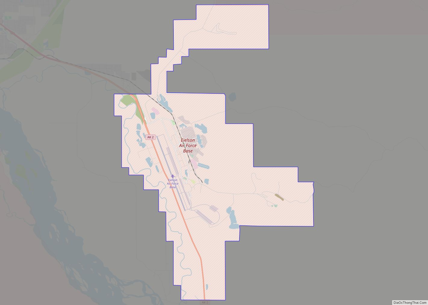
Eielson Air Force Base (IATA: EIL, ICAO: PAEI, FAA LID: EIL) is a United States Air Force (USAF) base located approximately 26 miles (42 km) southeast of Fairbanks, Alaska, and just southeast of Moose Creek, Alaska. It was established in 1943 as Mile 26 Satellite Field and redesignated Eielson Air Force Base on 13 January 1948. … Read more

Map of Egegik city

Map of Egegik city

Egegik (Central Yupik: Igyagiiq; Sugpiaq: Igya’iq, Igyagiq) is a city in Lake and Peninsula Borough, Alaska, United States. As of the 2020 census, the population of the city is 39, down from 109 in 2010. It has been home to cannery operations. If the city’s population somehow exploded in the decades to come, it will potentially become … Read more

Map of Eek city

Map of Eek city

Eek (Central Yupik: Iik) is a city in Bethel Census Area, Alaska, United States. As of the 2020 census there were 404 residents, the majority of whom being Alaska Natives. Eek city overview: Name: Eek city LSAD Code: 25 LSAD Description: city (suffix) State: Alaska County: Bethel Census Area Incorporated: July 9, 1970 Elevation: 3 ft … Read more

Map of Elim city

Map of Elim city, Alaska

Elim (Central Yupik: Neviarcaurluq; Inupiaq: Nivviaqhchauġluq) is a city in Nome Census Area, Alaska, United States. At the 2010 census the population was 330, up from 313 in 2000. Elim city overview: Name: Elim city LSAD Code: 25 LSAD Description: city (suffix) State: Alaska County: Nome Census Area Incorporated: October 17, 1970 Elevation: 36 ft (11 m) … Read more

Map of Elfin Cove CDP

Map of Elfin Cove CDP

Elfin Cove (Lingít: X̱’óot’k’) is a census-designated place (CDP) near the northwestern corner of Chichagof Island in Hoonah-Angoon Census Area, Alaska, United States. The population was 20 at the 2010 census, down from 32 at the 2000 census. Elfin Cove CDP overview: Name: Elfin Cove CDP LSAD Code: 57 LSAD Description: CDP (suffix) State: Alaska … Read more

Map of Ekwok city

Map of Ekwok city

Ekwok (Central Yupik: Iquaq) is a city in Dillingham Census Area, Alaska, United States. At the 2020 census, the population was 111. Ekwok city overview: Name: Ekwok city LSAD Code: 25 LSAD Description: city (suffix) State: Alaska County: Dillingham Census Area Incorporated: 1974 Elevation: 98 ft (30 m) Total Area: 18.01 sq mi (46.64 km²) Land Area: 16.75 sq mi (43.37 km²) Water … Read more

Map of Emmonak city

Map of Emmonak city

Emmonak (Central Yupik: Imangaq) is a city in Kusilvak Census Area, Alaska, United States. At the 2010 census the population was 762, down from 767 in 2000. Emmonak city overview: Name: Emmonak city LSAD Code: 25 LSAD Description: city (suffix) State: Alaska County: Kusilvak Census Area Incorporated: February 13, 1964 Elevation: 7 ft (2 m) Total Area: … Read more

Map of Eureka Roadhouse CDP

Map of Eureka Roadhouse CDP

Eureka Roadhouse is a census-designated place (CDP) in the Matanuska-Susitna Borough in the U.S. state of Alaska. It is part of the Anchorage Metropolitan Area. The population was 24 at the 2020 census. Eureka Roadhouse CDP overview: Name: Eureka Roadhouse CDP LSAD Code: 57 LSAD Description: CDP (suffix) State: Alaska County: Matanuska-Susitna Borough Elevation: 3,287 ft … Read more

Map of Ester CDP

Map of Ester CDP

Ester is a census-designated place (CDP) in Fairbanks North Star Borough, Alaska, United States. It is part of the Fairbanks, Alaska Metropolitan Statistical Area. The population in the CDP was 2,422 at the 2010 census, although there are only around 12 houses located inside of the village, the rest are in the surrounding area. The … Read more

Map of False Pass city

Map of False Pass city

False Pass (Aleut: Isanax̂) is a city on Unimak Island, in the Aleutians East Borough of southwestern Alaska, United States. Although the population was marked 397 including seasonal fish processing plant workers at the 2020 census, approximately 35 residents call it home year-round. False Pass city overview: Name: False Pass city LSAD Code: 25 LSAD … Read more

Map of Excursion Inlet CDP

Map of Excursion Inlet CDP

Excursion Inlet (Lingít: Ḵuyeiḵ’ L’e.aan) is a census-designated place (CDP) in Haines Borough in the U.S. state of Alaska. The population was 40 at the 2020 census, up from 12 in 2010. Excursion Inlet CDP overview: Name: Excursion Inlet CDP LSAD Code: 57 LSAD Description: CDP (suffix) State: Alaska County: Haines Borough Elevation: 79 ft (24 m) Total … Read more

Map of Evansville city

Map of Evansville CDP, Alaska

Evansville is a census-designated place (CDP) in Yukon-Koyukuk Census Area, Alaska, United States. The population was 15 at the 2010 census, down from 28 in 2000. The community is adjacent to Bettles. The community is named after Wilford Evans, Sr, who took part in the founding of Bettles Lodge. Evansville CDP overview: Name: Evansville CDP … Read more