Map of Willcox city

Map of Willcox city

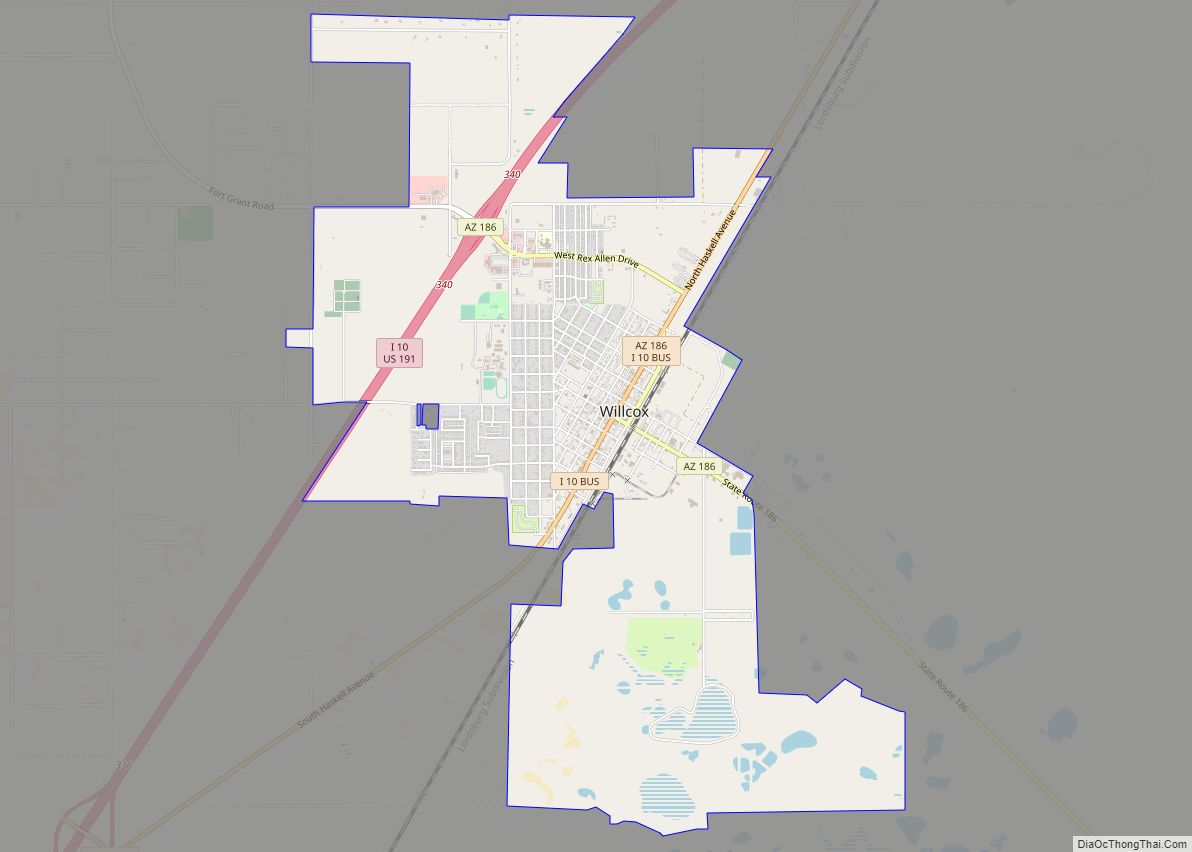
Willcox is a city in Cochise County, Arizona, United States. The city is located in the Sulphur Springs Valley, a flat and sparsely populated drainage basin dotted with seasonal lakes. The city is surrounded by Arizona’s most prominent mountain ranges, including the Pinaleño Mountains and the Chiricahua Mountains. Six of Arizona’s ten largest mountains are … Read more

Map of Window Rock CDP

Map of Window Rock CDP

Window Rock (Navajo: Tségháhoodzání, pronounced [tsʰéɰáhòːtsání]) is a census-designated place that serves as the seat of government and capital of the Navajo Nation, the largest territory in North America of a sovereign Native American nation. The capital lies within the boundaries of the St. Michaels Chapter, adjacent to the Arizona and New Mexico state line. Window … Read more

Map of Willow Valley CDP

Map of Willow Valley CDP

Willow Valley is an unincorporated community and census-designated place (CDP) in Mohave County, Arizona, United States. The population was 1,059 as of the 2020 census. Willow Valley CDP overview: Name: Willow Valley CDP LSAD Code: 57 LSAD Description: CDP (suffix) State: Arizona County: Mohave County Elevation: 475 ft (145 m) Total Area: 4.97 sq mi (12.88 km²) Land Area: 4.94 sq mi … Read more

Map of Willow Canyon CDP

Map of Willow Canyon CDP

Willow Canyon is a census-designated place in Pima County, in the U.S. state of Arizona. The population was “S” (Seasonal) at the 2010 census. Willow Canyon CDP overview: Name: Willow Canyon CDP LSAD Code: 57 LSAD Description: CDP (suffix) State: Arizona County: Pima County Elevation: 6,972 ft (2,125 m) Total Area: 0.37 sq mi (0.96 km²) Land Area: 0.37 sq mi (0.96 km²) … Read more

Map of Winslow city, Arizona

Map of Winslow city, Arizona

Winslow (Navajo: Béésh Sinil) is a city in Navajo County, Arizona, United States. According to the 2010 census, the population of the city is 9,655. It is approximately 57 miles (92 km) southeast of Flagstaff, 240 miles (390 km) west of Albuquerque, New Mexico, and 329 miles (529 km) southeast of Las Vegas. Winslow city overview: Name: Winslow … Read more

Map of Winslow West CDP

Map of Winslow West CDP

Winslow West is a census-designated place (CDP) in Coconino and Navajo counties in Arizona, United States. The population was 438 at the 2010 census. The entire community is off-reservation trust land belonging to the Hopi tribe. It lies just west of the city of Winslow, and is more than 50 km (31 mi) south of the main … Read more

Map of Winkelman town

Map of Winkelman town

Winkelman is a town in Gila and Pinal counties in Arizona, United States. According to the 2010 census, the population of the town was 353, all of whom lived in Gila County. Winkelman town overview: Name: Winkelman town LSAD Code: 43 LSAD Description: town (suffix) State: Arizona County: Gila County, Pinal County Elevation: 1,969 ft (600 m) … Read more

Map of Woodruff CDP

Map of Woodruff CDP, Arizona

Woodruff is an unincorporated community in Navajo County, Arizona, United States. Woodruff is 10.5 miles (16.9 km) southeast of Holbrook. Woodruff has a post office with ZIP code 85942. Woodruff was settled in 1876 by a group of members of the Church of Jesus Christ of Latter-day Saints led by Nathan Tenney and including Tenney’s son … Read more

Map of Wittmann CDP

Map of Wittmann CDP

Wittmann is an unincorporated community and census-designated place (CDP) in Maricopa County, Arizona, United States. As of the 2020 census, it had a population of 684, down from 763 in 2010. It is located along U.S. Route 60 in the central part of Arizona, 35 miles (56 km) northwest of central Phoenix, and is part of … Read more

Map of Wintersburg CDP

Map of Wintersburg CDP

Wintersburg is an unincorporated community and census-designated place in Maricopa County, Arizona, United States, located 48 miles (77 km) west of downtown Phoenix and 17 miles (27 km) west of Buckeye along Salome Highway. It is 4 miles (6 km) south of Exit 98 on Interstate 10. As of the 2020 census, Wintersburg had a population of 51, … Read more

Map of Young CDP

Map of Young CDP

Young is an unincorporated community and census-designated place (CDP) in Gila County, Arizona, United States. The population was 666 as of the 2010 census, up from 561 in 2000. Young CDP overview: Name: Young CDP LSAD Code: 57 LSAD Description: CDP (suffix) State: Arizona County: Gila County Elevation: 5,184 ft (1,580 m) Total Area: 47.82 sq mi (123.86 km²) Land … Read more

Map of York CDP, Arizona

Map of York CDP, Arizona

York, also known as York Valley, is a census-designated place in Greenlee County, Arizona, United States. As of the 2010 census, the population was 557. It is located along Arizona State Route 75, 12 miles (19 km) south of Clifton, the Greenlee County seat, and 16 miles (26 km) north of Duncan. Most residents work for Freeport-McMoRan … Read more