Map of Rosston town

Map of Rosston town, Arkansas

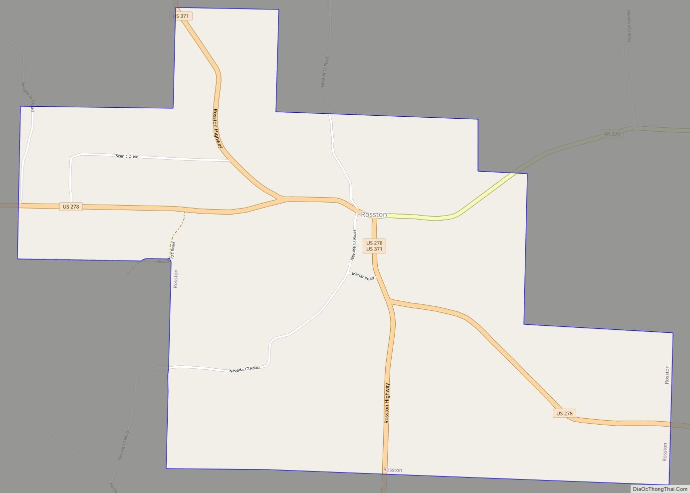
Rosston is a town in south-central Nevada County, Arkansas, United States. The population was 265 at the 2000 census. It is part of the Hope Micropolitan Statistical Area. Rosston town overview: Name: Rosston town LSAD Code: 43 LSAD Description: town (suffix) State: Arkansas County: Nevada County Elevation: 387 ft (118 m) Total Area: 4.44 sq mi (11.51 km²) Land Area: … Read more

Map of Rose Bud town

Map of Rose Bud town

Rose Bud town overview: Name: Rose Bud town LSAD Code: 43 LSAD Description: town (suffix) State: Arkansas County: White County Elevation: 630 ft (192 m) Total Area: 6.07 sq mi (15.71 km²) Land Area: 6.04 sq mi (15.64 km²) Water Area: 0.03 sq mi (0.07 km²) Total Population: 494 Population Density: 81.80/sq mi (31.59/km²) ZIP code: 72137 Area code: 501 FIPS code: 0560770 GNISfeature ID: 0054191 Online … Read more

Map of Rye CDP

Map of Rye CDP, Arkansas

Rye is a census-designated place in Cleveland County, Arkansas, United States. Per the 2020 census, the population was 123. Rye CDP overview: Name: Rye CDP LSAD Code: 57 LSAD Description: CDP (suffix) State: Arkansas County: Cleveland County Elevation: 187 ft (57 m) Total Area: 4.37 sq mi (11.31 km²) Land Area: 4.37 sq mi (11.31 km²) Water Area: 0.00 sq mi (0.00 km²) Total Population: 123 … Read more

Map of Russellville city, Arkansas

Map of Russellville city, Arkansas

Russellville is the county seat and largest city in Pope County, Arkansas, United States, with a 2021 estimated population of 29,338. It is home to Arkansas Tech University. Arkansas Nuclear One, Arkansas’ only nuclear power plant is nearby. Russellville borders Lake Dardanelle and the Arkansas River. It is the principal city of the Russellville Micropolitan … Read more

Map of Russell town

Map of Russell town, Arkansas

Russell is a town in White County, Arkansas, United States. Renee (Harvey) Garr is the current mayor. The population was 228 at the 2000 census. Russell town overview: Name: Russell town LSAD Code: 43 LSAD Description: town (suffix) State: Arkansas County: White County Elevation: 233 ft (71 m) Total Area: 0.21 sq mi (0.54 km²) Land Area: 0.21 sq mi (0.54 km²) Water … Read more

Map of Scott CDP

Map of Scott CDP, Arkansas

Scott is an unincorporated community and census-designated place (CDP) in Lonoke and Pulaski counties in the central part of the U.S. state of Arkansas. Per the 2020 census, the population was 97. It is part of the Little Rock–North Little Rock–Conway Metropolitan Statistical Area. Scott CDP overview: Name: Scott CDP LSAD Code: 57 LSAD Description: … Read more

Map of Salesville city

Map of Salesville city, Arkansas

Salesville is a city in Baxter County, Arkansas, United States. The population was 450 in 2010. Salesville city overview: Name: Salesville city LSAD Code: 25 LSAD Description: city (suffix) State: Arkansas County: Baxter County Elevation: 656 ft (200 m) Total Area: 4.52 sq mi (11.70 km²) Land Area: 4.51 sq mi (11.69 km²) Water Area: 0.00 sq mi (0.00 km²) Total Population: 473 Population Density: 104.76/sq mi … Read more

Map of Salem city

Map of Salem CDP, Arkansas

Salem is a census-designated place (CDP) in Saline County, Arkansas, United States. Per the 2020 census, the population was 2,544. It is part of the Little Rock–North Little Rock–Conway Metropolitan Statistical Area. Salem CDP overview: Name: Salem CDP LSAD Code: 57 LSAD Description: CDP (suffix) State: Arkansas County: Saline County Elevation: 472 ft (144 m) Total Area: … Read more

Map of Sedgwick town

Map of Sedgwick town, Arkansas

Sedgwick is a town in Lawrence County, Arkansas, United States. The population was 152 at the 2010 census, up from 112 at the 2000 census. Sedgwick town overview: Name: Sedgwick town LSAD Code: 43 LSAD Description: town (suffix) State: Arkansas County: Lawrence County Elevation: 262 ft (80 m) Total Area: 0.52 sq mi (1.35 km²) Land Area: 0.52 sq mi (1.35 km²) Water … Read more

Map of Searcy city

Map of Searcy city

Searcy (/ˈsɜːrsi/ SUR-see) is the largest city and county seat of White County, Arkansas, United States. According to 2019 Census Bureau estimates, the population of the city is 23,767. It is the principal city of the Searcy, AR Micropolitan Statistical Area which encompasses all of White County. The city takes its name from Richard Searcy, … Read more

Map of Scranton city

Map of Scranton city, Arkansas

Scranton is a city in Logan County, Arkansas, United States. The population was 224 at the 2010 census. It was named after Scranton, Pennsylvania. Scranton city overview: Name: Scranton city LSAD Code: 25 LSAD Description: city (suffix) State: Arkansas County: Logan County Elevation: 381 ft (116 m) Total Area: 0.51 sq mi (1.31 km²) Land Area: 0.51 sq mi (1.31 km²) Water Area: … Read more

Map of Sherrill town

Map of Sherrill town, Arkansas

Sherrill is a town in Plum Bayou Township, Jefferson County, Arkansas, United States. Its population was 84 at the 2010 U.S. census. It is included in the Pine Bluff, Arkansas Metropolitan Statistical Area. Sherrill town overview: Name: Sherrill town LSAD Code: 43 LSAD Description: town (suffix) State: Arkansas County: Jefferson County Incorporated: May 25, 1935; 87 … Read more