Map of Success town

Map of Success town

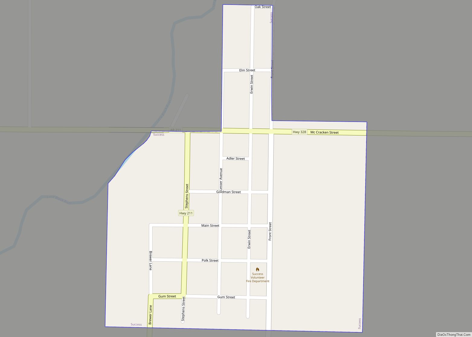
Success is a town in Clay County, Arkansas, United States. The population was 149 at the 2010 census. The origin of the name “Success” is obscure. Success town overview: Name: Success town LSAD Code: 43 LSAD Description: town (suffix) State: Arkansas County: Clay County Elevation: 295 ft (90 m) Total Area: 0.22 sq mi (0.58 km²) Land Area: 0.22 sq mi (0.58 km²) … Read more

Map of Subiaco town

Map of Subiaco town

Subiaco is a town in Logan County, Arkansas, United States. The population was 572 at the 2010 census. The town is named after Subiaco Abbey, which is located there, and which donated 80 acres (32 hectares) in the early 20th century for a townsite and railroad connection. Founded as a priory in 1878, Subiaco Abbey … Read more

Map of Sunset town

Map of Sunset town, Arkansas

Sunset is a town in Crittenden County, Arkansas, United States. The population was 198 at the 2010 census. Sunset town overview: Name: Sunset town LSAD Code: 43 LSAD Description: town (suffix) State: Arkansas County: Crittenden County Elevation: 220 ft (67 m) Total Area: 0.26 sq mi (0.68 km²) Land Area: 0.26 sq mi (0.68 km²) Water Area: 0.00 sq mi (0.00 km²) Total Population: 184 Population … Read more

Map of Summit city

Map of Summit city, Arkansas

Summit is a city in Marion County, Arkansas, United States. The population was 544 at the 2020 census, down from 604 in 2010. Summit city overview: Name: Summit city LSAD Code: 25 LSAD Description: city (suffix) State: Arkansas County: Marion County Elevation: 863 ft (263 m) Total Area: 1.21 sq mi (3.12 km²) Land Area: 1.21 sq mi (3.12 km²) Water Area: 0.00 sq mi … Read more

Map of Sulphur Springs CDP

Map of Sulphur Springs CDP, Arkansas

Sulphur Springs, also known as White Sulphur Springs, is a census-designated place (CDP) in Spring Township, Jefferson County, Arkansas, United States. Per the 2020 census, the population was 1,032. Sulphur Springs CDP overview: Name: Sulphur Springs CDP LSAD Code: 57 LSAD Description: CDP (suffix) State: Arkansas County: Jefferson County Elevation: 292 ft (89 m) Total Area: 5.54 sq mi … Read more

Map of Taylor city, Arkansas

Map of Taylor city, Arkansas

Taylor is a city in Columbia County, Arkansas, United States. The population was 566 at the 2010 census. Taylor city overview: Name: Taylor city LSAD Code: 25 LSAD Description: city (suffix) State: Arkansas County: Columbia County Elevation: 240 ft (73 m) Total Area: 0.99 sq mi (2.57 km²) Land Area: 0.99 sq mi (2.57 km²) Water Area: 0.00 sq mi (0.00 km²) Total Population: 579 Population … Read more

Map of Swifton city

Map of Swifton city

Swifton is a city in Jackson County, Arkansas, United States. The mayor is Craig Crider. The population was 798 at the 2010 census. Swifton was the hometown of Baseball Hall of Famer George Kell. Swifton city overview: Name: Swifton city LSAD Code: 25 LSAD Description: city (suffix) State: Arkansas County: Jackson County Elevation: 246 ft (75 m) … Read more

Map of Sweet Home CDP

Map of Sweet Home CDP, Arkansas

Sweet Home is a census-designated place (CDP) in Pulaski County, Arkansas, United States. Its population was 849 at the 2010 census. It is part of the ‘Little Rock–North Little Rock–AR Metropolitan Statistical Area’. Sweet Home CDP overview: Name: Sweet Home CDP LSAD Code: 57 LSAD Description: CDP (suffix) State: Arkansas County: Pulaski County Elevation: 272 ft … Read more

Map of Tillar city

Map of Tillar city

Tillar is a town in Desha and Drew counties in the U.S. state of Arkansas. The population was 225 at the 2010 census. The area west of it was known as Tillar Station. Frank Tillar Memorial Methodist Episcopal Church, South is listed on the National Register of Historic Places. Tillar city overview: Name: Tillar city … Read more

Map of Thornton city

Map of Thornton city, Arkansas

Thornton is a city in Calhoun County, Arkansas, United States. The population was 407 as of the 2010 census, down from 517 in 2000. It is part of the Camden, Arkansas micropolitan area. Thornton city overview: Name: Thornton city LSAD Code: 25 LSAD Description: city (suffix) State: Arkansas County: Calhoun County Elevation: 318 ft (97 m) Total … Read more

Map of Texarkana city

Map of Texarkana city, Arkansas

Texarkana is a city in the U.S. state of Arkansas and the county seat of Miller County, on the southwest border of the state. As of the 2020 census, it had a population of 29,387. The city is located across the state line from its twin city of Texarkana, Texas. The city was founded at … Read more

Map of Tontitown city

Map of Tontitown city

Tontitown is a city in northern Washington County, Arkansas, United States. The community is located in the Ozark Mountains and was founded by Italian settlers in 1898. Known for its grapes and wines, Tontitown has hosted the Tontitown Grape Festival continuously since 1898. It is part of the Northwest Arkansas region, serving as a bedroom … Read more