Map of Big Flat town

Map of Big Flat town

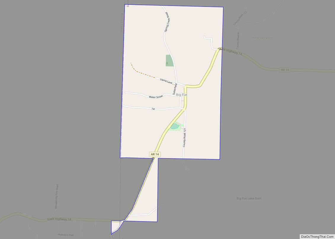
Big Flat is a town in Baxter and Searcy counties in the U.S. state of Arkansas. The population was 88 at the 2020 census. Big Flat town overview: Name: Big Flat town LSAD Code: 43 LSAD Description: town (suffix) State: Arkansas County: Baxter County, Searcy County Elevation: 1,253 ft (382 m) Total Area: 1.07 sq mi (2.78 km²) Land Area: … Read more

Map of Bethel Heights city

Map of Bethel Heights city

Bethel Heights was a city in Benton County, Arkansas, United States. Always a small, sparsely populated community, the region coalesced around a school named Bethel in the late 19th century but did not incorporate until 1967 to avoid annexation by larger neighboring communities. The town offered police and fire protection and wastewater service to residents, … Read more

Map of Black Oak town

Map of Black Oak town

Black Oak is a town in Craighead County, Arkansas, United States. The population was 262 at the 2010 census. It is included in the Jonesboro, Arkansas Metropolitan Statistical Area. Black Oak is the namesake of 1970s rock band Black Oak Arkansas and the setting of John Grisham’s novel A Painted House. Black Oak town overview: … Read more

Map of Birdsong town

Map of Birdsong town

Birdsong is a town in Mississippi County, Arkansas, United States. The population was 32 at the 2020 census, down from 41 in 2010. Birdsong town overview: Name: Birdsong town LSAD Code: 43 LSAD Description: town (suffix) State: Arkansas County: Mississippi County Elevation: 223 ft (68 m) Total Area: 0.20 sq mi (0.52 km²) Land Area: 0.20 sq mi (0.52 km²) Water Area: 0.00 sq mi … Read more

Map of Biggers town

Map of Biggers town

Biggers is a town in Randolph County, Arkansas, United States. The population was 305 at the 2020 census. Biggers town overview: Name: Biggers town LSAD Code: 43 LSAD Description: town (suffix) State: Arkansas County: Randolph County Elevation: 285 ft (87 m) Total Area: 1.02 sq mi (2.64 km²) Land Area: 1.00 sq mi (2.60 km²) Water Area: 0.02 sq mi (0.05 km²) Total Population: 305 Population … Read more

Map of Blevins city

Map of Blevins city

Blevins is a city in Hempstead County, Arkansas, United States. The population was 315 at the 2010 census, down from 365 in 2000. It is part of the Hope Micropolitan Statistical Area. Blevins city overview: Name: Blevins city LSAD Code: 25 LSAD Description: city (suffix) State: Arkansas County: Hempstead County Elevation: 420 ft (128 m) Total Area: … Read more

Map of Black Springs town

Map of Black Springs town

Black Springs is a town in Montgomery County, Arkansas, United States. The population was 96 at the 2020 census. Black Springs town overview: Name: Black Springs town LSAD Code: 43 LSAD Description: town (suffix) State: Arkansas County: Montgomery County Elevation: 774 ft (236 m) Total Area: 0.45 sq mi (1.16 km²) Land Area: 0.45 sq mi (1.15 km²) Water Area: 0.00 sq mi (0.01 km²) Total … Read more

Map of Black Rock city

Map of Black Rock city, Arkansas

Black Rock is a city in Lawrence County, Arkansas, United States, along the Black River. The population was 662 at the 2010 census. Black Rock city overview: Name: Black Rock city LSAD Code: 25 LSAD Description: city (suffix) State: Arkansas County: Lawrence County Elevation: 315 ft (96 m) Total Area: 3.42 sq mi (8.86 km²) Land Area: 3.29 sq mi (8.51 km²) Water … Read more

Map of Bluff City town

Map of Bluff City town, Arkansas

Bluff City is an unincorporated town (no elected mayor) in Nevada County, Arkansas, United States. The population was 158 at the 2000 census. It is part of the Hope Micropolitan Statistical Area. Bluff City town overview: Name: Bluff City town LSAD Code: 43 LSAD Description: town (suffix) State: Arkansas County: Nevada County Elevation: 361 ft (110 m) … Read more

Map of Blue Mountain town

Map of Blue Mountain town, Arkansas

Blue Mountain is a town in Logan County, Arkansas, United States. The population was 124 at the 2010 census. Edwin “Big Ed” Wilkes (1931–1998), a radio personality in Lubbock, Texas, was born in Blue Mountain but moved to Lubbock with his family in 1942. Blue Mountain town overview: Name: Blue Mountain town LSAD Code: 43 … Read more

Map of Blue Eye town

Map of Blue Eye town, Arkansas

Blue Eye is an incorporated town in Carroll County, Arkansas, United States. The population was 46 at the 2020 census. The population estimate is 52 as of 2021. Blue Eye, Arkansas, is adjacent to Blue Eye, Missouri. Blue Eye town overview: Name: Blue Eye town LSAD Code: 43 LSAD Description: town (suffix) State: Arkansas County: … Read more

Map of Bonanza city

Map of Bonanza city, Arkansas

Bonanza is a city in Sebastian County, Arkansas, United States. It is part of the Fort Smith, Arkansas–Oklahoma Metropolitan Statistical Area. At the 2010 Census, the population of Bonanza was 575. According to the 2018 US Census Bureau estimates, the population of Bonanza was 564. Bonanza began as a coal mining town of the Central … Read more