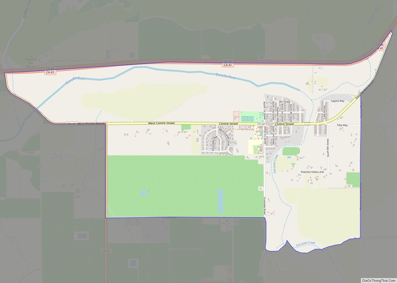
Map of Shelter Cove CDP

Map of Shelter Cove CDP

Shelter Cove is a census-designated place in Humboldt County, California. It lies at an elevation of 138 feet (42 m). Shelter Cove is on California’s Lost Coast where the King Range meets the Pacific Ocean. A nine-hole golf course surrounds the one-runway Shelter Cove Airport at the center of Shelter Cove’s commercial district. Utilities are … Read more

Map of Shell Ridge CDP

Map of Shell Ridge CDP

Shell Ridge is a census-designated place in Contra Costa County, California, United States. Shell Ridge sits at an elevation of 295 feet (90 m). The 2010 United States census reported Shell Ridge’s population was 959. Shell Ridge CDP overview: Name: Shell Ridge CDP LSAD Code: 57 LSAD Description: CDP (suffix) State: California County: Contra Costa County … Read more

Map of Shaver Lake CDP

Map of Shaver Lake CDP

Shaver Lake (formerly, Musick Creek and Musick Creek Heights) is a census-designated place (CDP) in Fresno County, California, United States. The population was 634 at the 2010 census, down from 705 at the 2000 census. Shaver Lake is on the southwest end of the lake of the same name, 10 miles (16 km) east of New … Read more

Map of Shingletown CDP

Map of Shingletown CDP

Shingletown is a census-designated place (CDP) in Shasta County, California, United States. Its population is 2,442 as of the 2020 census, up from 2,283 from the 2010 census. Shingletown is a small town located along California State Route 44 in the hills just below Mount Lassen. Shingletown has a history of logging large timber, including … Read more

Map of Shingle Springs CDP

Map of Shingle Springs CDP

Shingle Springs (formerly, Shingle Spring and Shingle) is a census-designated place (CDP) in El Dorado County, California, United States. The population was 4,432 at the 2010 census, up from 2,643 at the 2000 census. It is located about 40 miles (64 km) from Sacramento in the Gold Country foothills and sits directly on Highway 50. The … Read more

Map of Sheridan CDP, California

Map of Sheridan CDP, California

Sheridan is a census-designated place in Placer County, California, United States. It is located at the western edge of the county, along State Route 65. Sheridan is 7.5 miles (12.1 km) northwest of Lincoln. Its ZIP code is 95681 and area code 530. The elevation is 112 feet (34 m). The population was 1,238 at the 2010 … Read more

Map of Sierra Brooks CDP

Map of Sierra Brooks CDP

Sierra Brooks is a census-designated place (CDP) in Sierra County, California. Sierra Brooks sits at an elevation of 5,180 feet (1,580 m). The 2010 United States census reported Sierra Brooks’s population was 478. Sierra Brooks CDP overview: Name: Sierra Brooks CDP LSAD Code: 57 LSAD Description: CDP (suffix) State: California County: Sierra County Elevation: 5,180 ft (1,580 m) … Read more

Map of Shoshone CDP

Map of Shoshone CDP, California

Shoshone is a census designated place (CDP) in Inyo County, California, United States. The population was 22 at the 2020 census, down from 31 at the 2010 census. The town was founded in 1910. Although small, it is notable as a southern gateway to Death Valley National Park; in addition to being a junction of … Read more

Map of Sierra City CDP

Map of Sierra City CDP

Sierra City (Sierra, Spanish for “mountain range”) is a census-designated place in Sierra County, California, United States. The elevation of Sierra City is 4,147 feet (1,264 m), and the town is situated in the canyon of the North Yuba River on California State Route 49, twelve miles northeast of the county seat of Sierra County, Downieville. … Read more

Map of Sierraville CDP

Map of Sierraville CDP

Sierraville (Sierra, Spanish for “mountain range” and Ville, French for “town”) is a census-designated place in Sierra County, California, United States. It is at the southern end of the huge Sierra Valley which is used primarily as pasture and is also at the junction of California State Route 49 and California State Route 89 southwest … Read more

Map of Sierra Village CDP

Map of Sierra Village CDP

Sierra Village CDP overview: Name: Sierra Village CDP LSAD Code: 57 LSAD Description: CDP (suffix) State: California County: Tuolumne County FIPS code: 0671834 Online Interactive Map Sierra Village online map. Source: Basemap layers from Google Map, Open Street Map (OSM), Arcgisonline, Wmflabs. Boundary Data from Database of Global Administrative Areas. Sierra Village location map. Where … Read more

Map of Sierra Madre city

Map of Sierra Madre city

Sierra Madre (Spanish for “mother range”) is a city in Los Angeles County, California, whose population was 10,917 at the 2010 U.S. Census, up from 10,580 at the time of the 2000 U.S. Census. The city is in the foothills of the San Gabriel Valley below the southern edge of the Angeles National Forest. Pasadena … Read more