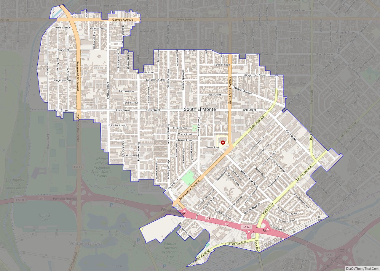
Map of South Pasadena city

Map of South Pasadena city, California

South Pasadena is a city in Los Angeles County, California, United States. As of the 2010 census, it had a population of 25,619, up from 24,292 in the 2000 census. It is located in West San Gabriel Valley. It is 3.42 square miles (8.9 km) in area and lies between the much larger city of Pasadena, … Read more

Map of South Oroville CDP

Map of South Oroville CDP

South Oroville is a census-designated place (CDP) in Butte County, California, United States. The population was 5,742 at the 2010 census, down from 7,695 at the 2000 census. For all practical purposes, South Oroville is tied to Oroville proper. South Oroville contains a negligible number of businesses, and all residents are dependent on the commercial … Read more

Map of South Monrovia Island CDP

Map of South Monrovia Island CDP

South Monrovia Island (pronunciation) is a census-designated place in Los Angeles County, California. It sits at an elevation of 384 feet (117 m). It is bounded to the west and north by Monrovia, to the east by Duarte, and to the south by Irwindale. The 2010 United States census reported that South Monrovia Island’s population was … Read more

Map of South San Jose Hills CDP

Map of South San Jose Hills CDP

South San Jose Hills is an unincorporated community and census-designated place in Los Angeles County, California, United States. The population was 20,551 at the 2010 census, up from 20,218 at the 2000 census. South San Jose Hills CDP overview: Name: South San Jose Hills CDP LSAD Code: 57 LSAD Description: CDP (suffix) State: California County: … Read more

Map of South San Gabriel CDP

Map of South San Gabriel CDP

South San Gabriel is a census-designated place (CDP) in Los Angeles County, California, United States. The population was 8,070 at the 2010 census, up from 7,595 at the 2000 census. South San Gabriel CDP overview: Name: South San Gabriel CDP LSAD Code: 57 LSAD Description: CDP (suffix) State: California County: Los Angeles County Elevation: 272 ft … Read more

Map of South San Francisco city

Map of South San Francisco city

South San Francisco is a city in San Mateo County, California, United States, located on the San Francisco Peninsula in the San Francisco Bay Area. The city is colloquially known as “South City”. The population was 66,105 at the 2020 census. South San Francisco city overview: Name: South San Francisco city LSAD Code: 25 LSAD … Read more

Map of Spaulding CDP

Map of Spaulding CDP, California

Spaulding (formerly Spalding Tract and Spaulding Tract) is a census-designated place in Lassen County, California. It is located on the west side of Eagle Lake, 2.1 miles (3.4 km) east-northeast of Whaleback Mountain and 3 miles (4.8 km) northeast of Eagle Lodge, at an elevation of 5138 feet (1566 m). Its population is 206 as of the … Read more

Map of South Whittier CDP

Map of South Whittier CDP

South Whittier (pronunciation) is an unincorporated community and census-designated place in Los Angeles County, California just south of the city of Whittier. As of the 2020 census, the CDP had a total population of 56,415, down from 57,156 at the 2010 census. On 16 November 2022, a driver veered onto the wrong side of the … Read more

Map of South Taft CDP

Map of South Taft CDP

South Taft is a census-designated place (CDP) in Kern County, California, United States. South Taft is located 0.5 miles (0.8 km) south of Taft, at an elevation of 1,017 feet (310 m). The population was 2,169 at the 2010 census, up from 1,898 at the time of the 2000 census. South Taft CDP overview: Name: South Taft … Read more

Map of Spring Valley Lake CDP

Map of Spring Valley Lake CDP

Spring Valley Lake is a census-designated place in the Victor Valley of the Mojave Desert, within San Bernardino County, California. It is located in Victorville on the Mojave River. Spring Valley Lake CDP overview: Name: Spring Valley Lake CDP LSAD Code: 57 LSAD Description: CDP (suffix) State: California County: San Bernardino County Elevation: 2,779 ft (847 m) … Read more

Map of Spring Garden CDP, California

Map of Spring Garden CDP, California

Spring Garden is a census-designated place (CDP) in Plumas County, California, United States. The population was 16 at the 2010 census, down from 55 at the 2000 census. Spring Garden CDP overview: Name: Spring Garden CDP LSAD Code: 57 LSAD Description: CDP (suffix) State: California County: Plumas County Elevation: 3,999 ft (1,219 m) Total Area: 0.652 sq mi (1.690 km²) … Read more

Map of Spreckels CDP

Map of Spreckels CDP

Spreckels is an unincorporated community and census-designated place (CDP) in the Salinas Valley of Monterey County, California, United States. Spreckels is located 3 miles (5 km) south of Salinas, at an elevation of 62 ft (19 m). Its population was 692 at the 2020 census. Spreckels is one of the best-preserved company towns in the United States. It … Read more