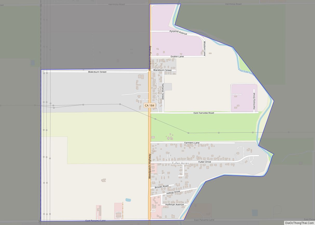
Map of Garden Acres CDP

Map of Garden Acres CDP

Garden Acres is a census-designated place (CDP) in San Joaquin County, California, United States. The population was 10,648 at the 2010 census, up from 9,747 at the 2000 census. It is the most populous CDP in San Joaquin County. Garden Acres CDP overview: Name: Garden Acres CDP LSAD Code: 57 LSAD Description: CDP (suffix) State: … Read more

Map of Garberville CDP

Map of Garberville CDP

Garberville is a census-designated place in Humboldt County, California. It is located on the South Fork of the Eel River 52 miles (84 km) south-southeast of Eureka, at an elevation of 535 feet (163 m). The population was 913 at the 2010 United States Census. It is approximately 200 miles (320 km) north of San Francisco, California, and … Read more

Map of Galt city

Map of Galt city, California

Galt is a city in Sacramento County, California. It is part of the Sacramento metropolitan area. The population was 23,647 at the 2010 census, up from 19,472 at the 2000 census. Galt city overview: Name: Galt city LSAD Code: 25 LSAD Description: city (suffix) State: California County: Sacramento County Incorporated: August 16, 1946 Elevation: 47 ft … Read more

Map of Garey CDP

Map of Garey CDP

Garey is a census-designated place in Santa Barbara County, California located east of U.S. Route 101 about 10 miles (16 km) southeast of Santa Maria and 5 miles (8.0 km) north of Sisquoc. The ZIP Code is 93454, and the community is inside area code 805. The population was 68 at the 2010 census. Garey CDP overview: … Read more

Map of Gardena city

Map of Gardena city, California

Gardena is a city located in the South Bay region of Los Angeles County, California, United States. The population was 58,829 at the 2010 census, up from 57,746 at the 2000 census. Until 2014, the US census cited the City of Gardena as the place with the highest percentage of Japanese Americans in California. Gardena’s … Read more

Map of Garden Farms CDP

Map of Garden Farms CDP

Garden Farms is a census-designated place in San Luis Obispo County, California. Garden Farms sits at an elevation of 955 feet (291 m). The 2010 United States census reported Garden Farms’s population was 386. Garden Farms is a subdivision located between Santa Margarita and Atascadero, California. Garden Farms CDP overview: Name: Garden Farms CDP LSAD Code: … Read more

Map of Gazelle CDP

Map of Gazelle CDP

Gazelle is a census-designated place (CDP) in Siskiyou County, California, United States. Its population is 95 as of the 2020 census, up from 70 from the 2010 census. Gazelle CDP overview: Name: Gazelle CDP LSAD Code: 57 LSAD Description: CDP (suffix) State: California County: Siskiyou County Elevation: 2,769 ft (844 m) Total Area: 0.581 sq mi (1.505 km²) Land Area: … Read more

Map of Gasquet CDP

Map of Gasquet CDP

Gasquet (/ˈɡæs.kiː/, GAS-kee; Tolowa: Mvs-ye) is an unincorporated community in Del Norte County, California, United States, 22 mi (35 km) southwest of the Oregon border and 18 miles (29 km) northeast of Crescent City. The name is in honor of Horace Gasquet. Horace Gasquet was the owner of the gold mines, hotel, railway, bank and post office; he … Read more

Map of Garnet CDP

Map of Garnet CDP

Garnet is a census-designated place in Riverside County, California. Garnet sits at an elevation of 797 feet (243 m). The 2010 United States census reported Garnet’s population was 7,543. Garnet CDP overview: Name: Garnet CDP LSAD Code: 57 LSAD Description: CDP (suffix) State: California County: Riverside County Elevation: 797 ft (243 m) Total Area: 11.425 sq mi (29.591 km²) Land Area: … Read more

Map of Geyserville CDP

Map of Geyserville CDP

Geyserville (formerly Clairville) is an unincorporated community and census-designated place (CDP) in Sonoma County, California, USA. Located in the Wine Country, Geyserville has a small selection of restaurants, bed and breakfasts, and wineries. Geyserville is located on California State Route 128, close to US Route 101. The population was 862 at the 2010 census. Geyserville … Read more

Map of Gerber CDP

Map of Gerber CDP

Gerber is a census-designated place (CDP) in Tehama County, California. Gerber sits at an elevation of 226 feet (69 m). The 2010 United States census reported Gerber’s population was 1,060. Gerber CDP overview: Name: Gerber CDP LSAD Code: 57 LSAD Description: CDP (suffix) State: California County: Tehama County Elevation: 226 ft (69 m) Total Area: 0.923 sq mi (2.390 km²) Land … Read more

Map of Georgetown CDP, California

Map of Georgetown CDP, California

Georgetown (formerly Growlersburg) is a census-designated place (CDP) in El Dorado County, California. It is the northeasternmost town in the California Mother Lode. The population was 2,367 at the 2010 census, up from 962 in 2000. The town is registered as California Historical Landmark #484. Georgetown CDP overview: Name: Georgetown CDP LSAD Code: 57 LSAD … Read more