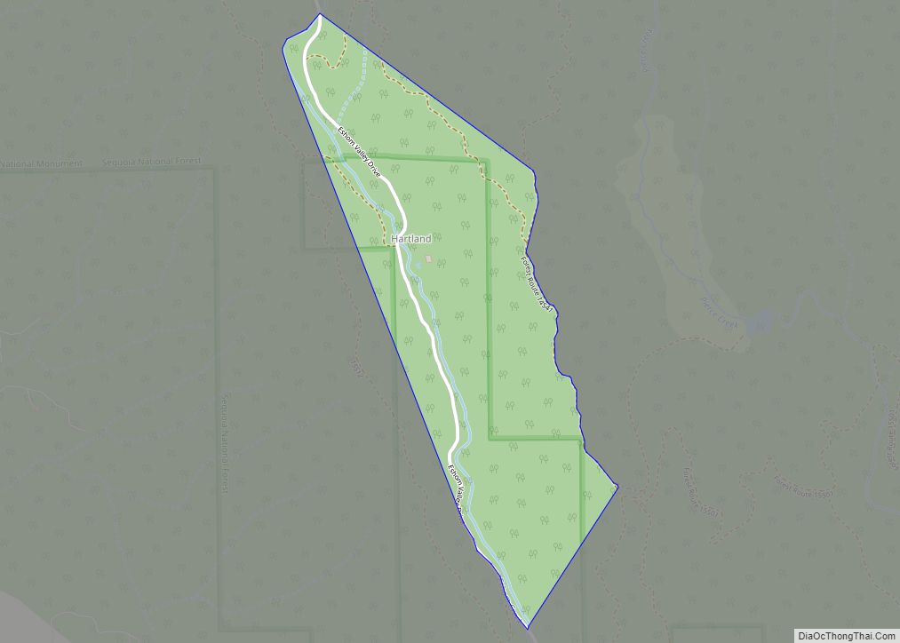
Map of Hawaiian Gardens city

Map of Hawaiian Gardens city

Hawaiian Gardens is a city in Los Angeles County, California, United States. It is the smallest city in the county in area (approximately 1.0 mi) and was incorporated on April 9, 1964. The population was 14,254 at the 2010 census, down from 14,779 at the 2000 census. The city’s unusual name originated with a 1920s refreshment … Read more

Map of Hat Creek CDP

Map of Hat Creek CDP

Hat Creek is a census designated place (CDP) in Shasta County, California. Hat Creek is situated at an elevation of 3,422 feet (1,043 m). Its population is 266 as of the 2020 census, down from 309 from the 2010 census. Hat Creek is located 26 miles (42 km) north of Lassen Park, 13 miles (21 km) southeast of … Read more

Map of Hasley Canyon CDP

Map of Hasley Canyon CDP

Hasley Canyon is a census-designated place in the Sierra Pelona mountains of Los Angeles County, California. Hasley Canyon sits at an elevation of 1,765 feet (538 m). The 2010 United States census reported Hasley Canyon’s population was 1,137. Hasley Canyon CDP overview: Name: Hasley Canyon CDP LSAD Code: 57 LSAD Description: CDP (suffix) State: California County: … Read more

Map of Healdsburg city

Map of Healdsburg city

Healdsburg is a city located in Sonoma County, in California‘s Wine Country. At the 2010 census, the city had a population of 11,254. Owing to its three most important wine-producing regions (the Russian River, Dry Creek, and Alexander Valley AVAs), Healdsburg has been continuously awarded one of the top 10 small towns in America and … Read more

Map of Hayfork CDP

Map of Hayfork CDP

Hayfork is a census-designated place (CDP) in Trinity County, California, United States. Its population is 2,324 as of the 2020 census, down from 2,368 from the 2010 census. Hayfork CDP overview: Name: Hayfork CDP LSAD Code: 57 LSAD Description: CDP (suffix) State: California County: Trinity County Elevation: 2,310 ft (704 m) Total Area: 72.120 sq mi (186.791 km²) Land Area: … Read more

Map of Hawthorne city

Map of Hawthorne city, California

Hawthorne is a city in the Los Angeles metropolitan area, located in southwestern Los Angeles County, California. It is part of a seventeen-city region commonly called the South Bay. As of the 2020 US census, Hawthorne had a population of 88,083. Hawthorne city overview: Name: Hawthorne city LSAD Code: 25 LSAD Description: city (suffix) State: … Read more

Map of Heber CDP

Map of Heber CDP, California

Heber is a census-designated place (CDP) in Imperial County, California. Heber is located 4.5 miles (7 km) north-northwest of Calexico. The population was 4,275 at the 2010 census, up from 2,566 in 2000. Heber CDP overview: Name: Heber CDP LSAD Code: 57 LSAD Description: CDP (suffix) State: California County: Imperial County Elevation: −10 ft (−3 m) Total Area: … Read more

Map of Herald CDP

Map of Herald CDP

Herald is a census-designated place in Sacramento County, California. Herald sits at an elevation of 79 feet (24 m). It is located east of the city of Galt along State Route 104. The ZIP Code is 95638, and the community is inside area code 209. The 2010 United States census reported that Herald’s population was 1,184. … Read more

Map of Hemet city

Map of Hemet city

Hemet is a city in the San Jacinto Valley in Riverside County, California. It covers a total area of 27.8 square miles (72 km), about half of the valley, which it shares with the neighboring city of San Jacinto. The population was 89,833 at the 2020 census. The founding of Hemet, initially called South San Jacinto, … Read more

Map of Hermosa Beach city

Map of Hermosa Beach city

Hermosa Beach (Hermosa, Spanish for “Beautiful”) is a beachfront city in Los Angeles County in the U.S. state of California, United States. Its population was 19,728 at the 2020 U.S. Census. The city is located in the South Bay region of the Greater Los Angeles area; it is one of the three Beach Cities. Hermosa … Read more

Map of Herlong CDP

Map of Herlong CDP

Herlong is a census-designated place in Lassen County, California. Herlong is located at the extreme eastern edge of the Sierra Nevada Mountain Range in the southeastern region of Honey Lake Valley, 8 miles (13 km) north of Doyle, at an elevation of 4,114 feet (1,254 m). Its population is 237 as of the 2020 census, down from … Read more

Map of Hercules city

Map of Hercules city

Hercules is a city in western Contra Costa County, California. Situated along the coast of San Pablo Bay, it is located in the eastern region of the San Francisco Bay Area, about 10 miles (16 km) north of Berkeley, California. As of 2010, its population was 24,060, according to the United States Census Bureau. The site … Read more