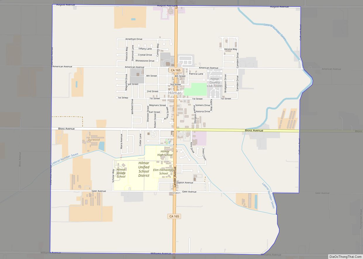
Map of Home Gardens CDP

Map of Home Gardens CDP

Home Gardens is a census-designated place (CDP) in Riverside County, California, United States. It is within the City of Corona‘s sphere of influence. The population was 11,203 at the 2020 census, down from 11,507 at the 2010 census. Home Gardens CDP overview: Name: Home Gardens CDP LSAD Code: 57 LSAD Description: CDP (suffix) State: California … Read more

Map of Home Garden CDP

Map of Home Garden CDP

Home Garden is a census-designated place (CDP) in Kings County, California, United States. The community is about 1.5 miles (2.4 km) southeast of the city of Hanford. It is part of the Hanford–Corcoran Metropolitan Statistical Area. The population was 1,761 at the 2010 United States Census. Home Garden CDP overview: Name: Home Garden CDP LSAD Code: … Read more

Map of Holtville city, California

Map of Holtville city, California

Holtville (formerly, Holton) is a city in Imperial County, California. Holtville is located 10.5 miles (17 km) east of El Centro. The population was 5,939 at the 2010 census, up from 5,612 in 2000. Holtville city overview: Name: Holtville city LSAD Code: 25 LSAD Description: city (suffix) State: California County: Imperial County Incorporated: July 1, 1908 … Read more

Map of Homewood Canyon CDP

Map of Homewood Canyon CDP

Homewood Canyon is a census-designated place (CDP) in Inyo County, California. Homewood Canyon sits at an elevation of 3,074 feet (937 m). The 2010 United States census reported Homewood Canyon’s population was 44. Prior to the 2010 census, the former CDP of Homewood Canyon-Valley Wells was split into Homewood Canyon and Valley Wells. Homewood Canyon CDP … Read more

Map of Homestead Valley CDP

Map of Homestead Valley CDP

Homestead Valley is a census-designated place in San Bernardino County, California. Homestead Valley sits at an elevation of 3,022 feet (921 m). The 2010 United States census reported Homestead Valley’s population was 3,032. Homestead Valley CDP overview: Name: Homestead Valley CDP LSAD Code: 57 LSAD Description: CDP (suffix) State: California County: San Bernardino County Elevation: 3,022 ft … Read more

Map of Homeland CDP

Map of Homeland CDP, California

Homeland is a census-designated place (CDP) in Riverside County, California, United States. The population was 5,969 at the 2010 census, up from 3,710 at the 2000 census. Homeland CDP overview: Name: Homeland CDP LSAD Code: 57 LSAD Description: CDP (suffix) State: California County: Riverside County Elevation: 1,604 ft (489 m) Total Area: 4.270 sq mi (11.058 km²) Land Area: 4.270 sq mi … Read more

Map of Hoopa CDP

Map of Hoopa CDP

Hoopa (formerly Hupa, Ho-pah, Hoo-pah, Hupo, and Up-pa) is an unincorporated community and census-designated place (CDP) in Humboldt County, California. It is located 10 miles (16 km) south of Weitchpec, at an elevation of 328 feet (100 m). The ZIP Code is 95546. Hoopa is a rural town located entirely on the federally-designated reservation of the Hupa … Read more

Map of Hood CDP

Map of Hood CDP

Hood is a census-designated place in Sacramento County, California, United States. Hood is located on the Sacramento River and California State Route 160 15 miles (24 km) south of downtown Sacramento. Hood has a post office with ZIP code 95639 that was established in 1912. The community was named in 1910 after William Hood, chief engineer … Read more

Map of Honcut CDP

Map of Honcut CDP

Honcut (formerly, Moores Station) is a census-designated place in Butte County, California. It lies at an elevation of 108 feet (33 m). Lower Honcut Rd. links the community to California State Route 70. Honcut is near the Yuba County line. Honcut’s post office was established in 1856 and moved back and forth several times between … Read more

Map of Hornitos CDP

Map of Hornitos CDP

Hornitos (Spanish for “Little ovens”) is a census-designated place in Mariposa County, California, United States. It is located on Burns Creek 25 miles (40 km) by road south of Coulterville, at an elevation of 843 feet (257 m). The population was 38 at the 2020 census, down from 75 at the 2010 census. The town is featured … Read more

Map of Hornbrook CDP

Map of Hornbrook CDP

Hornbrook is a census-designated place (CDP) in Siskiyou County, California, United States. Its population is 266 as of the 2020 census, up from 248 from the 2010 census. It was named by the Southern Pacific Railroad in 1886, derived from the brook that ran through David Horn’s property. Hornbrook CDP overview: Name: Hornbrook CDP LSAD … Read more

Map of Hopland CDP

Map of Hopland CDP

Hopland (formerly Sanel) is a census-designated place in Mendocino County, California, United States. It is located on the west bank of the Russian River 13 miles (21 km) south-southeast of Ukiah, in the Sanel Valley, at an elevation of 502 feet (153 m). The population was 661 at the 2020 census, down from 756 at the 2010 … Read more