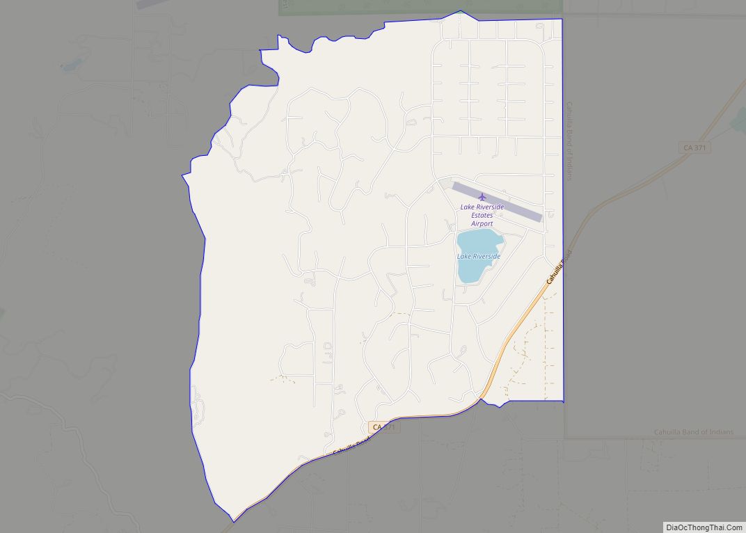
Map of Lake Wildwood CDP

Map of Lake Wildwood CDP

Lake Wildwood is a census-designated place (CDP) in Nevada County, California, United States. The population was 4,991 at the 2010 census, up from 4,868 at the 2000 census. Lake Wildwood is mainly a gated community and news about the CDP is published in a twice a month newspaper, The Wildwood Independent. Local businesses and residences … Read more

Map of Lakeland Village CDP

Map of Lakeland Village CDP

Lakeland Village is a census-designated place (CDP) in Riverside County, California, United States. The population was 11,541 at the 2010 census, more than double the 5,626 reported at the 2000 census. Lakeland Village CDP overview: Name: Lakeland Village CDP LSAD Code: 57 LSAD Description: CDP (suffix) State: California County: Riverside County Elevation: 1,283 ft (391 m) Total … Read more

Map of Lakehead CDP

Map of Lakehead CDP

Lakehead is a census-designated place (CDP) in Shasta County, California. Lakehead sits at an elevation of 1,447 feet (441 m). Lakehead is located halfway between Seattle and Los Angeles. Its population is 469 as of the 2020 census, up from 461 from the 2010 census. Lakehead was established as a CDP for the 2010 census, replacing … Read more

Map of Lakeview CDP, California

Map of Lakeview CDP, California

Lakeview is a census-designated place (CDP) in Riverside County, California, United States. The population was 2,104 at the 2010 census, up from 1,619 at the 2000 census. The community is named for nearby Mystic Lake. Lakeview CDP overview: Name: Lakeview CDP LSAD Code: 57 LSAD Description: CDP (suffix) State: California County: Riverside County Elevation: 1,450 ft … Read more

Map of Lakeside CDP

Map of Lakeside CDP, California

Lakeside is a census-designated place (CDP) in the East County region of San Diego County, California. The population was 21,152 at the 2020 census, up from 20,648 as of the 2010 census. Lakeside CDP overview: Name: Lakeside CDP LSAD Code: 57 LSAD Description: CDP (suffix) State: California County: San Diego County Elevation: 413 ft (126 m) Total … Read more

Map of Lakeport city

Map of Lakeport city, California

Lakeport is an incorporated city and the county seat of Lake County, California. This city is 125 miles (201 km) northwest of Sacramento. Lakeport is on the western shore of the county namesake, Clear Lake, at an elevation of 1,355 feet (413 m). The population was 5,026 at the 2020 census, up from 4,753 at the 2010 … Read more

Map of Lanare CDP

Map of Lanare CDP

Lanare is a community and census-designated place (CDP) in Fresno County, California, United States. The population was 589 at the 2010 census, up from 540 at the 2000 census. Lanare is located 24 miles (39 km) south-southwest of Fresno, at an elevation of 207 feet (63 m). The name is derived from Llewellyn A. Nares, the … Read more

Map of Lamont CDP

Map of Lamont CDP, California

Lamont is a census-designated place (CDP) in Kern County, California, United States. Lamont is located 9 miles (14 km) south-southeast of downtown Bakersfield, at an elevation of 404 feet (123 m). The population was 15,120 at the 2010 census, up from 13,296 at the 2000 census. Lamont CDP overview: Name: Lamont CDP LSAD Code: 57 LSAD Description: … Read more

Map of Lakewood city

Map of Lakewood city, California

Lakewood is a city in Los Angeles County, California, United States. The population was 80,048 at the 2010 census. It is bordered by Long Beach on the west and south, Bellflower on the north, Cerritos on the northeast, Cypress on the east, and Hawaiian Gardens on the southeast. Major thoroughfares include Lakewood (SR 19), Bellflower, … Read more

Map of Las Flores CDP

Map of Las Flores CDP

Las Flores (Spanish for “The Flowers”) is a census-designated place (CDP) in Tehama County, California. Las Flores sits at an elevation of 249 feet (76 m). The 2010 United States census reported Las Flores’s population was 187. Las Flores CDP overview: Name: Las Flores CDP LSAD Code: 57 LSAD Description: CDP (suffix) State: California County: Tehama … Read more

Map of Larkspur city

Map of Larkspur city, California

Larkspur is a city in Marin County, California, United States. Larkspur is located 3 miles (4.8 km) south of San Rafael, at an elevation of 43 feet (13 m). As of the 2020 Census, the city’s population was 13,064. Larkspur’s Police Department is shared with that of the neighboring Corte Madera and town of San Anselmo as … Read more

Map of Larkfield-Wikiup CDP

Map of Larkfield-Wikiup CDP

Larkfield-Wikiup is a census-designated place unincorporated area in Sonoma County, California, United States. The population was 8,884 at the 2010 census, up from 7,479 at the 2000 census. It comprises the Mark West area between Santa Rosa (to the south), Windsor (north), Calistoga (east), and Fulton (west). There are at least four schools within the … Read more