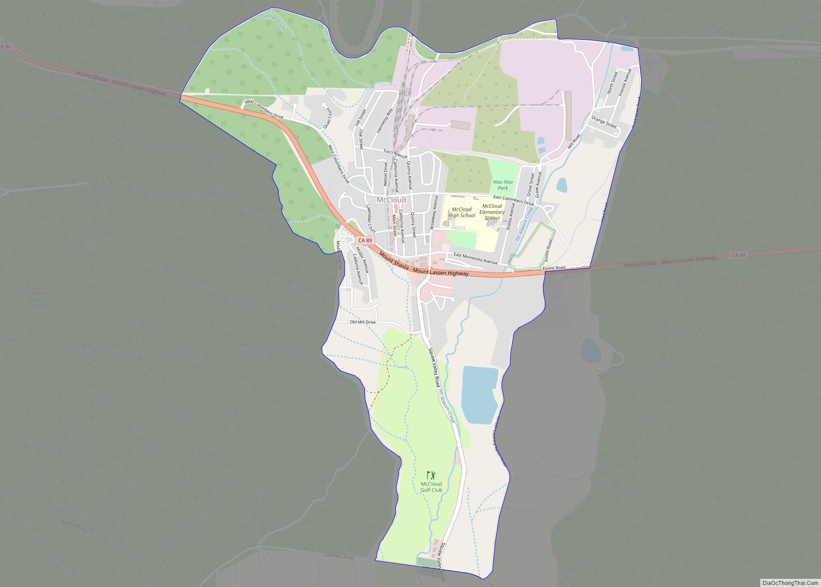
Map of McKittrick CDP

Map of McKittrick CDP, California

McKittrick is an unincorporated community in Kern County, California, United States. McKittrick is 14 miles (23 km) northwest of Taft, at an elevation of 1,056 feet (322 m). The population was 115 at the 2010 census, down from 160 at the 2000 census.For statistical purposes, the United States Census Bureau has defined McKittrick as a census-designated place … Read more

Map of McKinleyville CDP

Map of McKinleyville CDP

McKinleyville (formerly Minorsville) is a census-designated place (CDP) in Humboldt County, California McKinleyville is located 5.25 miles (8.4 km) north of Arcata, at an elevation of 141 feet (43 m). The population was 15,177 at the 2010 census, up from 13,599 at the time of the 2000 census. This unincorporated community is the third largest community, after … Read more

Map of McSwain CDP

Map of McSwain CDP

McSwain is an unincorporated community and census-designated place (CDP) in Merced County, California, United States. McSwain sits at an elevation of 144 feet (44 m). As of the 2020 census, the population was 4,480, up from 4,171 in 2010. McSwain CDP overview: Name: McSwain CDP LSAD Code: 57 LSAD Description: CDP (suffix) State: California County: Merced … Read more

Map of Meadow Vista CDP

Map of Meadow Vista CDP

Meadow Vista is a census-designated place (CDP) in Placer County, California, United States. It is part of the Sacramento–Arden-Arcade–Roseville Metropolitan Statistical Area. The population was 3,217 at the 2010 census, up from 3,096 at the 2000 census. The California Office of Environmental Health Hazard Assessment has issued a safe eating advisory for any fish caught … Read more

Map of Meadow Valley CDP

Map of Meadow Valley CDP

Meadow Valley is a census-designated place (CDP) in Plumas County, California, United States. The population was 453 at the 2020 census, down from 464 at the 2010 census. Meadow Valley CDP overview: Name: Meadow Valley CDP LSAD Code: 57 LSAD Description: CDP (suffix) State: California County: Plumas County Elevation: 3,776 ft (1,151 m) Total Area: 8.520 sq mi (22.066 km²) … Read more

Map of Mead Valley CDP

Map of Mead Valley CDP

Mead Valley is a census-designated place in Riverside County, California. Mead Valley sits at an elevation of 1,663 feet (507 m). The 2010 United States census reported Mead Valley’s population was 18,510. Mead Valley is located in a valley of the same name in the northeastern Temescal Mountains, south of the city of Riverside and west … Read more

Map of Meiners Oaks CDP

Map of Meiners Oaks CDP

Meiners Oaks is an unincorporated community lying west of the city of Ojai in Ventura County, California, United States. The population was 3,571 at the 2010 census. For statistical purposes, the United States Census Bureau has defined Meiners Oaks as a census-designated place (CDP). Meiners Oaks CDP overview: Name: Meiners Oaks CDP LSAD Code: 57 … Read more

Map of Mecca CDP

Map of Mecca CDP, California

Mecca is an unincorporated community located in Riverside County, California, United States. The desert community lies on the north shore of the Salton Sea in the eastern Coachella Valley and is surrounded by agricultural land. Mecca CDP overview: Name: Mecca CDP LSAD Code: 57 LSAD Description: CDP (suffix) State: California County: Riverside County Elevation: −187 ft … Read more

Map of Meadowbrook CDP, California

Map of Meadowbrook CDP, California

Meadowbrook is a census-designated place in Riverside County, California. Meadowbrook sits at an elevation of 1,621 feet (494 m). The 2010 United States census reported Meadowbrook’s population was 3,185. Meadowbrook CDP overview: Name: Meadowbrook CDP LSAD Code: 57 LSAD Description: CDP (suffix) State: California County: Riverside County Elevation: 1,621 ft (494 m) Total Area: 6.879 sq mi (17.817 km²) Land Area: … Read more

Map of Menlo Park city

Map of Menlo Park city

Menlo Park is a city at the eastern edge of San Mateo County within the San Francisco Bay Area of California in the United States. It is bordered by San Francisco Bay on the north and east; East Palo Alto, Palo Alto, and Stanford to the south; and Atherton, North Fair Oaks, and Redwood City … Read more

Map of Mendota city

Map of Mendota city, California

Mendota is a U.S. city in Fresno County, California. The population was 11,014 at the 2010 U.S. Census. CA State Routes 180 and 33 run through the agricultural city. Mendota is located 8.5 miles (14 km) south-southeast of Firebaugh, at an elevation of 174 feet (53 m). Mendota city overview: Name: Mendota city LSAD Code: 25 … Read more

Map of Mendocino CDP

Map of Mendocino CDP

Mendocino (Spanish for “of Mendoza”) is an unincorporated community and census-designated place (CDP) in Mendocino County, California, United States. Mendocino is located 10 miles (16 km) south of Fort Bragg at an elevation of 154 feet (47 m). The population of the CDP was 932 at the 2020 census. The town’s name comes from Cape Mendocino 85 … Read more