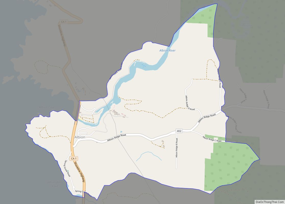
Map of Alleghany CDP

Map of Alleghany CDP

Alleghany is a small census-designated place in Sierra County, California, United States in the Sierra Nevada. It is situated in the Gold Country and continues to be a significant locale for gold mining. The Sixteen To One Mine has been in operation since the days of the California Gold Rush. The town is 20 miles … Read more

Map of Aliso Viejo city

Map of Aliso Viejo city

Aliso Viejo (Spanish for “Old Sycamore”) is a city in the San Joaquin Hills of southern Orange County, California. It had a population of 47,823 as of the 2010 census, up from 40,166 as of the 2000 census. It became Orange County’s 34th city on July 1, 2001, the only city in Orange County to … Read more

Map of Alhambra city

Map of Alhambra city, California

Alhambra (/ælˈhæmbrə/ (listen), /ɑːlˈhɑːmbrə/ (listen), Spanish: [aˈlambɾa]; from “Alhambra”) is a city located in the western San Gabriel Valley region of Los Angeles County, California, United States, approximately eight miles from the Downtown Los Angeles civic center. It was incorporated on July 11, 1903. As of the 2020 census, the population was 82,868. The city’s ZIP … Read more

Map of Allensworth CDP

Map of Allensworth CDP

Allensworth is an unincorporated community in Tulare County, California. Established by Allen Allensworth in 1908, the town was the first in California to be founded, financed, and governed by African-Americans. The original townsite is designated as Colonel Allensworth State Historic Park. The 2020 United States census reported Allensworth’s population was 531, up from 471 at … Read more

Map of Allendale CDP

Map of Allendale CDP, California

Allendale is a census-designated place (CDP) in Solano County, California, United States. Allendale is located along Interstate 505 6.5 miles (10.5 km) west of Dixon. The population was 1,506 at the 2010 census. Allendale CDP overview: Name: Allendale CDP LSAD Code: 57 LSAD Description: CDP (suffix) State: California County: Solano County Elevation: 121 ft (37 m) Total Area: … Read more

Map of Almanor CDP

Map of Almanor CDP

Almanor (formerly, Plumas Pines) was a census-designated place (CDP) in Plumas County, California, United States. The population was 0 at the 2010 Census. Almanor is located 7 miles (11.3 km) south-southeast of Chester. Almanor CDP overview: Name: Almanor CDP LSAD Code: 57 LSAD Description: CDP (suffix) State: California County: Plumas County Elevation: 4,554 ft (1,388 m) Total Area: … Read more

Map of Alpine Village CDP

Map of Alpine Village CDP

Alpine Village (formerly, Alphine Village) is a census-designated place (CDP) in Alpine County, California, United States. The population was 114 at the 2010 census, down from 136 at the 2000 census. Alpine Village CDP overview: Name: Alpine Village CDP LSAD Code: 57 LSAD Description: CDP (suffix) State: California County: Alpine County Elevation: 5,604 ft (1,708 m) Total … Read more

Map of Alpaugh CDP

Map of Alpaugh CDP

Alpaugh is a census-designated place (CDP) in Tulare County, California, United States. The population was 1,026 at the 2010 census, up from 761 at the 2000 census. It is named for John Alpaugh, one of the officers of the Home Extension Colony which reclaimed (or land speculated on) the land the town is built on. … Read more

Map of Alondra Park CDP

Map of Alondra Park CDP

Alondra Park (pronunciation), also known as El Camino Village, is a census designated place (CDP) in Los Angeles County, California, United States. It is the unincorporated area north of Alondra Community Regional Park and El Camino College. It is east of Lawndale, south of Hawthorne, west of Gardena, and north of Torrance. Manhattan Beach Boulevard … Read more

Map of Alta CDP

Map of Alta CDP, California

Alta (Spanish for “Upper”) is a small unincorporated community and census-designated place (CDP) in Placer County, California, United States, about 30 miles (48 km) northeast of Auburn. The village is located off Interstate 80 and along the historical First transcontinental railroad. The ZIP code is 95701 and the area code 530. One of the few buildings … Read more

Map of Alta Sierra CDP

Map of Alta Sierra CDP

Alta Sierra (Spanish for “Upper Range”) is a census-designated place (CDP) in Nevada County, California, United States. The population was 6,911 at the 2010 census, up from 6,522 at the 2000 census. Alta Sierra CDP overview: Name: Alta Sierra CDP LSAD Code: 57 LSAD Description: CDP (suffix) State: California County: Nevada County Elevation: 2,310 ft (704 m) … Read more

Map of Alpine CDP, California

Map of Alpine CDP, California

Alpine is a census-designated place (CDP) in the Cuyamaca Mountains of San Diego County, California. Alpine had a population of 14,696 at the 2020 census, up from 14,236 at the 2010 census. The town is largely surrounded by the Cleveland National Forest and borders two reservations of the Kumeyaay Nation, Viejas and Sycuan, and the … Read more